Mid day model update--
GGEM (and the NAM extracted) go negative tilt to early and chung the the low as an inland runner.
This would be a driving rain storm with maybe a little snow to start and maybe a little snow to end.
 |
| Inland Runner-- |
Note on the top image that low pressure is in WESTERN NC-- That's not a good snow track for us. Once the low passes to our east the upper air support COULD support some snow, but those don't always work out as modeled.
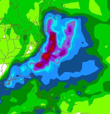
The 12Z ECMWF slide a little east and is basically just concentrates all the precipitation on the coast. The precip maps are the least reliable feature, but it does bring caution at this point. The inch line of precipt is from near Raleigh, NC to RIC to DOVER DE-- Well to our east. Guns those areas with a little spill over to our region. Taken literal, about a quarter inch of liquid that falls as snow.
In what is NO STUNNER, the GFS moves away from the Miller B ( Storm forms off the coast rather then rides out of the Gulf of Mexico) It is now a Miller A that rides the coast from the Gulf of Mexico, but matches the EC with not much moisture in our area. Actually, much less and once it reaches near Cape Hatteras it goes out to sea.
 |
| Miller A -- grazes our area. This run looked great until about hour 90. |
My plan is to view the evening data and have some type of update tomorrow AM-- things SHOULD become a little clearer at that time.
No comments:
Post a Comment