Model data- Worst type of storm with no real hedge.
Looking at the 0z NAM-- it's literally an 4-5 hour event if that. Flurries or drizzle for an hour, bangs to decent snow for 2 hours and ends as drizzle/flurries. Maybe an inch or two anywhere east of the Mountains NORTH of the Staunton River.
SO, 1-3 mountains, Coating to 2 inches east of Mountains. Get up early-- snow ends fast and melts by early afternoon. :)
Danville, South Boston, barring a miracle this won't be your event.
**Heading to my Dad's in Parkesburg, WV-- stopped for the night in Lewisburg for the snow and a swim at the hotel. We already got a little sledding in. Hoping to get 4 inches out of this event up here**
Friday, December 28, 2012
The little event that won't--
If you've read my tendencies, you'd note that I usually blog when I feel strongly about the event. So, a blog this AM on the cusp of our first possible accumulating snow isn't a good sign.
Strike 1- Marginal temps. No model gets the last 2-4k feet below freezing.
Strike 2. Strung out low pressure. That's not a good sign for heaving precipitation. With temps near or above freezing we'd need heavy stuff to cool the atmosphere and or accumulate.
Strike 3- total QPF is forecast between .15 and .25-- that's much much either way and we know it will mix.
The NWS forecast is under and inch of snow in Roanoke and maybe a little ice in Lynchburg. These seem about right. Places like Blacksburg and Radford could see 2-3 inches and Hot Springs and Lewisburg could see 2-4 or so. Will update if any major changes, but I'm not expecting any. If anywhere east of the Blue Ridge sees an inch, consider that a blessing from the snow gods.
Tuesday, December 25, 2012
Ice event and the next 10 days.
Tricky forecast for Lynchburg, VA- Roanoke, a little easier but still tricky. Few degrees either way make a BIG difference.
The Good:
We need the rain and will get quite a bit. Between an inch and a inch and a half most regions.
Ice impact-- While we could see some ice build up on the trees in places that get freezing rain, but the rain will come down heavy so it won't have a chance to freeze as much + temps won't be that cold.
The Bad:
If I were king of the world, I'd of expanded advisories a county south and east of Lynchburg to include Campbell and Appomattox. It may not materialize, but considering the holiday, people heading to work-- if there is marginal temps a bridge or overpass is icy-- bad situation.
The Data:
Interesting trends as far as temps-- we spiked early and between the cloud cover later in the day and a little colder air dipping in from the north, we went from 53 to 43 in a couple hours. Temps will hover in the upper 30's until the rain starts. There is some dry air, especially between 6 and 10k feet. This will cool the atmosphere from the mid levels down mix the rain with sleet for a time between lets say 5 am and 10 am tomorrow. The surface temp will slowly drop as well and will stop in Lynchburg somewhere between 31 and 34) Obviously, getting below 32 is a big deal. Elevations above 1500 feet or so will get much more freezing rain. Just outside Roanoke in the elevations above 1200 feet should see a decent amount of ice accrual as well.
The issue with the sleet is this-- ideally, you want air colder than -3 or -4 C for 4-5 thousand feet for sleet. This is more like -2 or -3 for 3 thousand feet as modeled. So, this is marginal for sleet. However, some sleet will fall. I can see the ground getting coated for a period tomorrow between 7-9 am .
Biggest thing-- be careful in the am. Check the weather, warn your friend to check. A few degrees-- better safe than sorry.
The Future:
Saturday has a possible event on tap. AS of now, looks like a risk of a moderate snow event of maybe 2-4 inches. Still need to shift over the data. Part of the deal will be what happens with our first storm and where that ends up.
Jan 2-3 has another "potential event". If you track some of my blogs, I talk about the the "PNA" or ridging in the west. Seems like we MAY have some cold air and SOME chance of of a decent storm. I like the potential for 7 days out.
Monday, December 24, 2012
Bat signal engaged
Well, this may be one of my more terrible storms as far as the waffle. I felt good as far as where were we 48 hours ago, but the rapid and consistent move of all the models made it seem like that was the movement it was heading. I was expecting MAYBE a little sleet in Lynchburg to start, and Roanoke maybe a little sleet and freezing rain. Nothing that was a big deal and over early.
The model data started to shift back this AM and now all agree the other way. Taken literally-- 2-3 inches of sleet in Lynchburg and even more snow/sleet in Roanoke. The weather happens, the models try and guess.
The facts:
The storm arrives after midnight. When there is low level cold air, it's common that some places start as what seems as rain and as the intensity picks up it goes from that to even sleet or snow. There was an ice event in December of 2005 that started as freezing rain, went to snow-- back to sleet and then a pretty good ice event. This may end up somewhat like that.
Heaviest of the precipitation will be from dawn on Boxing day till mid afternoon.
The speculation:
If the colder trends are legit- we will have Winter Storm warning west of the Blue Ridge and advisories east, north of the Staunton river. Since .5 is a warning, these cold be expanded.
The issues:
We need the cold air to get here. If the cold air is a little later or storm quicker, we will get more rain and less ice. This is a very plausible option at this time.
I love these "computer generated snow maps- they are usually full of crap. this one is, as it's accumulating snow when it should be sleet. This one has from the GFS has 4 inches in Lynchburg near Campbell county and 0 down near Brookneal in Campbeel County. My guess is this map isn't seeing the warm air above 5000k feet and this is more sleet. As a result, it's more like 25% of what falls here like an inch in LYH. Possible, not a forecast. Yet.
Sunday, December 23, 2012
Pulling the plug

Well, well, well-- In literally a day, we went from a decent event to "mainly" rain. I'm not ready to proclaim ALL rain, but the good news in all this is we have been dry and the 1 to 2.5 inches of rain between Christmas eve and Boxing Day will be welcomed.
What happened??
The storm cut much further west, pulling up warm air in front of it and-- despite the models looking about the same, my take is it over did the cold air to begin with.
More rain later in the week and "maybe" a winter type event Jan 2-3.
Saturday, December 22, 2012
Vanilla swings by after Christmas--

I've been waiting to fire up the bat signal for this event for a couple days (plus having Christmas fun with the kids). It's been clear there will be an event Boxing Day for 2-3 days now, but the fine details are waiting to be hammered out.
QUICK DETAILS:
Showers Christmas eve-- Mostly dry Christmas day. Snow and sleet (freezing rain southside) develop overnight Christmas and begin that transition into freezing rain and maybe even some rain during Boxing day.If your want "long term guess" on accumulations. LYH area- 1-2 inches of snow and sleet and a pretty good glaze of ice. ROA and BCB 2-5 inches of snow and sleet, some glaze. Southside- Less sleet, more glaze and rain. Best chance for 6 inches of snow or more will be Staunton up to Harrisonburg.
LONGER TERM:
We will be getting into a colder pattern with several chances for snow and ice starting Dec 26th. Other dates include around the 29th and Jan 2-4th.
SYNOPTICAL PATTERN:
Low pressure forms and attempts to move up to our west- Let's say from East Texas to East Tennessee. There is a block up to the north that force it to "jump" to the coast at some point. At the same time, colder air is being forced east of the mountains by a "banana" high and cold air damming will provide us with a winter event. Good shoot this will be a "warning" criteria event. (Advisory means lower impact)

Notes on map- the blue line is "freezing" line at 5k feet. note how it's being forced down east of the Blue Ridge. This is in response to that "cold" on the map. If you can read the "pressure" lines note how they are bundled up around the storm and broad near the high pressure bringing the cold. Further, note how they "bend" east of the mountains. This will supply cold air that starts most areas as snow and then transitions to sleet and then finally freezing rain. Southside into Farmville has a good shot at having some plain rain too.
Further updates later today.
Wednesday, December 12, 2012
May your days be merry and bright
And may all...
My December portion of the outlook has been an epic fail as we are running VERY high departures so far and still have some days of above normal before a colder snap.
Social media has made the local TV meteorologist job hard-- because of Twitter, Blog and FB people have access to comments from many source and some (like me) even read the models themselves. With that, some of the model data yesterday seemed to indicate a SHOT at some snow next week. My take was I thought it was bad run of the model and didn't comment. Seems like I was right--(as of now :)
With that, a colder pattern is creeping in. We'll have a few waves of storms between now and the end of next week. Snow WELL up into New England will be common along with some sleet and freezing rain. Boring stuff to your average person down here in Lynchburg, VA
The problem with our pattern has been that while we've had decent blocking in the Arctic and heading that was with a -NAO, the pacific has been a mess with a trough over the west coast (leads to ridging over the SE USA and remember Trough== cooler, ridge== warmer. Also, some of the higher lattitude blocking signals we monitor called the EPO has been positive, which doesn't allow what is called cross polar flow (AKA- getting the coldest air to our side of the globe. It's been pretty cold over Europe)
Those signals look to be getting better and with a pulse in the SOI-- which is a scale that measures pressure differences between Darwin and Tahiti, it also seems to be linked with "energy" in the sub tropical jet. There is about a 2 week lag time from a pulse to an event, so crude math says between December 24-27th or so is a decent time to think SOME colder air could be local and SOME type of storm cold be in our area. This is conjecture and by no means a forecast, but we are keeping our eyes on this time frame.
Also, mid week system next week COULD drop some Mt snows on the back sides, so if you have a cabin at 2500 feet get ready! Updates will be more fequent as the weather is getting a little more interesting.
Wednesday, November 21, 2012
Thanksgiving Weekend-- Like your dinner
Warm the first couple days, then cold leftovers.
Thanksgiving and Black Friday will be NICE days-- 60 or so most areas, give or take a few degrees, MAYBE 65 on Friday.
Strong cold front passes late Friday evening and we DRASTICALLY cool off Saturday. 40-45 for a high will be the norm with some upslope snows in the Mountains for those travelling west and north.
November will end up colder than normal-- we are running a -4 in LYH and w couple warmer days won't shave much off and then we go back into the "cooler".
What does the crystal ball say about December?
Cold air has been building up in Canada nicely. I often blog about high latitude blocking. We've had SOME blocking, but not a ton in November and we are WELL below normal. There are SOME signs of some blocking developing, some could be strong. The issue is WHERE the block sets up. A key issue in my outlook talked about the problems with the pacific and regarding the pdo and how that COULD lead to less blocking out west. In this case, if we don't get that blocking the strongest of the cold will be in the mid west and then into the NORTHEAST up near Boston and that region.
However, whenever there is arctic air in the northern tier, all we need is a day or so of the a trigger to pull down colder air and a properly timed storm. Those TEND to be more ice events, so we are on the lookout. The first 15 days or so of December have potential for cold, snow and ice, but this is not a lock.
Ironically, the stratosphere has NOT been favorable for cold up to this point. So, if we get a cold period without cooperation and then a boost later on, we COULD be looking at a pretty harsh winter. (Conjecture, not a forecast)
Hope all enjoy a great Thanksgiving- 2012 has been a great year for me and hope the same for you and your friends and family.
Sunday, November 11, 2012
Winter Forecast 12-13
Well, well , well--
For a time, it seemed the winter outlook would fall on the easy side of things with a close to moderate el nino . Those for winters have pretty strong correlation to cold and snow, at least relative to our norms. The Nino faded and now we are left making strong judgement calls to what this winter holds.
Winter outlook for Lynchburg, Roanoke, Danville, Blacksburg Virginia-
Quick thoughts.
1. Won't be as mild as last winter.
2. Won't be as snowy as 09-10.
3. Should be a tad drier than normal
Quick view.
Winter temp average 1-2f colder than normal.
Precipitation 15% below normal
Snowfall- Take your local and subtract 5. Your range will be in that 5.
Example- Lynchburg is listed as 18 inches - so 13-18 inches. Roanoke is 21 so lets go 16-21 for the winter.
Monthly break down temp wise--
December - 1
January +2
February -3.
Thought process
(Google these indices or email me a question)
Losing the El Nino hurt-- as that seems to usually trump other global patterns. This will be a neutral warm el nino, meaning it's not a nino, but temps are above normal in that region.
QBO- Has been very negative and should begin to move towards positive. This should allow for some blocking towards the North Pole.
PDO- Negative to very negative. This isn't a good sign for cold and snow, especially south of the mason dixon line. Oddly, when the trend is negative, but spikes positive for the winter they trend to be snowier. This will NOT be the case.
Long range model- Both the CFSv2 and ECMWF have been all over the place, but both don't see VERY cold winters.
SOI- Index that measures pressures in Darwin and Tahiti- More La Nina like, than El Nino.
Snow cover- snow cover in Eurasia has been demonstrated to be a harbinger of the Arctic oscillation, where as when the snow cover advances rapidly, the chain of events leads to more blocking at the pole. This year was THIRD on the list behind 09-10 and 1976-77, both that had TREMENDOUS cold snaps. The biggest difference in those two was the EL Nino in 09-10 leading to all the snow cover. I weighted this the most.
The biggest issue with snowfall will NOT be cold, but lack of a sub tropical jet. My guess is 4-5 days out systems may look to have potential but unless we have strong blocking, these will end up being events NORTH of DC-- or we get much less than modeled due to downsloping, etc. (Especially east of the Blue Ridge) I can see several events where we get 2-4 inches of snow with the nice glaze of sleet and freezing rain on top.
Monday, November 5, 2012
So close, yet so far away.
Due to time constraints ( due to a new puppy) I won't post TOO many maps.
Most guidance is WELL to our east with the storm, but the reigning champ, the ECMWF pulls Sandy CLOSE enough the a little light rain and snow back into Lynchburg while Farmville, Charlottsville, Harrisonburg and even Amherst get a decent mid fall snow. Rare, but not unheard of. (See Nov 1953 and Nov 1968)
ECMWF phases the two vorts sooner and the the storm is closer and more negative tilt. Here is a shot of it as the snow/rain has BARELY scraped LYH. If something CLOSE to this happens, will be a dicey forecast for our region. I'll assume this is more right then wrong, but give the other models 25% weight and move everything 50 miles Northeast at this time.
Temps are BARELY below freezing and a couple degrees either way could make a huge difference.

Sunday, November 4, 2012
The Mid Week NorEaster!
I almost long for the days when I was breaking events 5-6 days out before the media. Social media and just the net in general have quickly added to the avenues people can find medium range thoughts and speculation.
Sandy was nothing short of a spectacular event with catastrophic results, especially in the Northern Jersey/NYC area. Despite the quick "labeled" transition to extra tropical the system had a HUGE storm surge and like a landfalling tropical system, strongest winds on the north side. I LOVE interesting weather events, but seeing that level of human suffering his just horrific. Having numerous friends in the region and chatting on FB makes it interesting.
Perhaps I owed my loyal readers a quick update about this event. I was on the fence with some models far enough west for a couple days to bring meaningful precipitation back into our region. The models have trended a little east and the best precipitation slides basically Charlottesville/Famville east.
Do I think that's accurate? As of now-- Yes. I don't think we need will see much rain (or snow) from this event. Best chance for snow will be north well north of Harrisonburg from Winchester up 81 to NY. And, honestly maybe even NOT into VA.
Can this change? sure-- weather forecasting is always fluid. We need a faster phasing of the jet to slide this thing west AND it to BOMB further south, lets say as it passes Cape Hatteras. I'll update quickly in the AM when I see the overnight data.
My winter outlook will be out later this week. Sean Sublette had a nice one for WSET.
http://www.wset.com/video?clipId=7883542&autostart=true
I like his thought process
Allen Huffman is an excellent met from NC State-
http://www.examiner.com/article/winter-2012-13-forecast-part-1
http://www.examiner.com/article/winter-2012-13-forecast-part-2
Hope to get my final thoughts by Friday.
Monday, October 29, 2012
Landfall- Atlantic city.
Well, well, well--
Leg one of my landfall at Atlantic City has verified well- Needing a Philly to just north of Hagerstown and we've won the triathlon.
Crazy storm reports-- Winds on the north side of the storm WELL over Hurricane force gusts-- verified at 94, a few unverified reports OVER 100 in the NYC,Long Island area.
Crazy rains from New Jersey SW to DC area. 5-8 inches common with more on the way. Coastal regions have had historic flooding, beach erosion and much of NYC proper has MAJOR water issues.
My plan was to head up to Lewisburg WV tonight to see some snow, but I've got a recovering sick child. He's better, but needed daddy for the evening. Much of WV looks to be demolished overnight with a verified 8 inch total from a friend in Summerville, WV
For the bulk of our region- occasional light to maybe moderate rain continues. Winds will pick up with gusts over 60 in the Mts and 50 elsewhere. I don't think we see MUCH rain.. under a half inch near LYH and under a quarter inch Danville, Martinsville and Roanoke. These are hedged HI-- I think LESS rain.
IF, IF , IF we can get heavier bands in the region after 2 AM-- it will be mixed with snow. My doubts are we DON'T get heavier bands in.
Snow map on short term model-- sees 2 feet by noon tomorrow MUCH of WV.

Here is the Lynchburg profile at 6 am-- I highlighted the last three layers, or about 1500 feet of the atmosphere that's above freezing. However, it's only a few degrees, like 36-37 so if it comes down hard we COULD hoover around around 33 with some snow. My hunch is the rain stays BARELY east of us and once it cools we are basically dry.

Near miss with moisture and temps... don't be shocked to see a few flurries.
Batten Down the Hatches.
SuperStorm Monday...
Sandy has done pretty much as expected-- she swung out east to near 70 longitude and is not making the shift west. My thoughts were Atlantic City to near Philly to near Hagerstown, MD.
That's going to be rather close-and she's gotten stronger with pressure down to 942 MB.
We've had light to moderate rain region wide over night and the snow change has been sooner than anticipated with snowfall into Blackburg and Hot Springs already.
Rain region wide today with temps steady or even falling slowly. Winds should be increasing as the day goes on.
I'll update with some model data at noon. With the snow change earlier, will have the evaluate. If you look at this radar look..
http://radar.weather.gov/radar.php?rid=FCX&product=NCR&overlay=11101111&loop=yes
snow in the mountains and MAYBE already west of Martinsville.
Saturday, October 27, 2012
Stay on Target....
I see no drastic changes to any forecast you are going to see out there. The bottom line is-- does it land in the Delmarva OR some where in New Jersey.
.jpg)

.jpg)
I've posted a few times on Facebook that I see a landfall of Sandy near Atlantic City--moving to Philly and then sitting just north of Hagerstown. This doesn't meant THOSE areas will get the worst. More like 125 miles to the SOUTH of the landfall point and upwards of 250 miles NORTH will get big rains and strong and long duration tropical storm winds. Outside the immediate coast of DE and NJ, I don't think there will be "Hurricane Force" winds very far inland. (like as in a few miles) However, Billions of damage via erosion on the coast and down trees, power outages, etc will extend far and away from the "landfall" point. Pretty dangerous anywhere along the coast for flooding and winds.
Sandy actually had a good bit of weakening last night and was down graded to a tropical storm. She's looking better and back up to a Hurricane. I can see it peaking at a cat two before the slingshot to the west as she approaches the coast.
For the Lynchburg-Roanoke area specifically.
For our area- we'll have some lighter showers tomorrow into Monday and heavier rains will begin to move in from the NW and E. Don't be shocked if SOME areas-- don't see much rain, especially West of Lynchburg west to Roanoke and Martinsville.
Winds- Highest elevations will see the worst with gusts over 50, where the west of the world lives will be a duration of 20-30 miles with gusts to 40.
Snow- EPIC event for the MTS of West Virginia. Still very up in the air where some models pull the storm so far W that Garret County actually changes back to rain on a WARM FRONT out the NE while lewisburg and Beckley areas get 12+ inches of snow. If it takes the PERFECT tract-- Don't be shocked for a remote place like Snowshoe or Davis to get 3-4 feet.
Where people live like Lynchburg-- We can see some snow showers or flurries Late Monday night and Tuesday. I don't expect any risk of accumulations, but knowing we got a few flakes off a hurricane would be pretty cool. With a VERY cold pool of air aloft, we could get a decent little burst of snow SOMEWHERE east of the Mountains Tuesday. (Decent for October, NOT accumulating)
My PERSONAL plan is to work Monday and then shoot up to Lewisberg WV Monday night-- My office is in Roanoke right off 220 and it's 75 miles. Only about 20 of those miles would be snow covered getting back Tuesday morning.
One crazy snow map-- 19+ inches most of WV and some of the snow sneaks east of the mts. ( Don't be shocked if some place gets a coating to a slopping inch or two Tuesday.

Friday, October 26, 2012
Still Holding...
After another 24 hours of model runs, there has been a modest switch towards the ECMWF with the more southern route of Sandy. The GFS or American model really had moved in that direction for a couple runs but then went back to a more northern landfall.
Where things sit now.
1. She's coming-- no doubt.
All coastal regions need to be aware and plan ahead. The watches have been extended up past Cape Hattares for Tropical Storm conditions and they should be extended north. Because it jogs west NORTH, I suspect Hurricane watches issues from near Virginia Beach to Long Island or something like that.
2. For our region, some lighter rains out in front of the storm late tonight into tomorrow then the waiting game starts. We need the southern track for the rain to really impact us and the **possible ** change to snow. Ironically, the ECMWF has moved so far south, as modeled the snow actually misses Lynchburg MOSTLY to the south and west. We do get a good bit of rain in the lines of 2-3 inches. Roanoke gets some snow and the NRV and Highlands get a nice snow. (After a little rain) The other models that are further north have the backside snow, just little or no rain.
3. This is still extremely fluid where the smaller changes matter. With that, despite this being a large system, the worst impact will be along coastal regions. The further south the landfall, the better shot of seeing decent rainfall in our region.
4. Snowfall will impact the higher grounds. As said before, the models were CRAZY with bringing heavy snow into Roanoke, Lynchburg, Danville and Richmond. The last 2 runs of the ECMWF have been so far south that Lyncburg actually is too far north and east and the best snows chance past to our west, south southwest and south east. Don't over obsess because as stated before, my suspicions are the model is a little to cold on the back side of the storm.
 First map- 12z run of the ECMWF snowfall-- CRAZY 4 feet totals over mountains of WV. This assumes a 10-1 ratio which likely isn't correct (the entire storm at least) plus the snow/no snow line is VERY close to LYH. The snow that falls to our south and east wraps around the city later. I'm not forecasting this, but it's been some of the craziest model outputs ever. Other models have crazy 1-2 foot solutions over the Mountains of WV, with coating to a couple inches east of there. Those are MUCH more reasonable.
 This last map shows how if the coldest models verify, how Lynchburg could miss snow, but Roanoke and Danville get snow. Because of the warm core nature of the a hurricane, if you are too close to the center, the warn nature keeps you RAIN. As the storm moves WEST the cold air wraps around the south side of the low. The grid on the bottom shows how the first true shade of blue STOP around the Blue Ridge and show up lets say south of the Staunton River. With that, I've stated before the models are very likely too cold top to bottom, but crazier things have happened. For LYH to have any shot of seeing accumulating snow, Sandy comes ashore near Southern New Jersey and crosses the Delaware Bay and heads into Northern Maryland coming to a point near Hagerstown, MD or slightly north.
Bottom line- if you want to see snow drive to the Ski resorts of West Virginia!
Where things sit now.
1. She's coming-- no doubt.
All coastal regions need to be aware and plan ahead. The watches have been extended up past Cape Hattares for Tropical Storm conditions and they should be extended north. Because it jogs west NORTH, I suspect Hurricane watches issues from near Virginia Beach to Long Island or something like that.
2. For our region, some lighter rains out in front of the storm late tonight into tomorrow then the waiting game starts. We need the southern track for the rain to really impact us and the **possible ** change to snow. Ironically, the ECMWF has moved so far south, as modeled the snow actually misses Lynchburg MOSTLY to the south and west. We do get a good bit of rain in the lines of 2-3 inches. Roanoke gets some snow and the NRV and Highlands get a nice snow. (After a little rain) The other models that are further north have the backside snow, just little or no rain.
3. This is still extremely fluid where the smaller changes matter. With that, despite this being a large system, the worst impact will be along coastal regions. The further south the landfall, the better shot of seeing decent rainfall in our region.
4. Snowfall will impact the higher grounds. As said before, the models were CRAZY with bringing heavy snow into Roanoke, Lynchburg, Danville and Richmond. The last 2 runs of the ECMWF have been so far south that Lyncburg actually is too far north and east and the best snows chance past to our west, south southwest and south east. Don't over obsess because as stated before, my suspicions are the model is a little to cold on the back side of the storm.


Bottom line- if you want to see snow drive to the Ski resorts of West Virginia!
Thursday, October 25, 2012
ECMWF holds again over night-- WOW
I was expecting to wake up and the ECMWF had backed away from the EXTREME event in our area. We know this is already a significant event as it crashed into Cuba as Cat 2 ALMOST cat 3 event.
The EC has answered and said--


The EC has answered and said--
Sandy crashes ashore near Rehobeth, DE (Props to my Mom, that's where she lives) and retrogrades as it transitions from tropical to non tropical(moves backwards) and goes over DC and then up in Pennsylvania.
I'm still very skeptical that EVEN if track verifies as shown that we get the snow as shown east of the Mts. I'm half joking, but I think the MTS may sink a few inches from the weight of 2-3 feet of snow.

This shows 2 feet plus in the MTS to our west, and close to a foot in Lynchburg. 4-8 inches all the way down to Danville and Richmond. I doubt anything close to this verifies, but WOW on the consistency.
So, landfall still seems to be somewhere between VAB and Cape Cod and then it moves WNW. The further south, more rain/snow our region gets. There are models that show other solutions with landfall further north. One thought in my mind is the magnitude of the block and how this will impact the overall track of Sandy as she transitions from tropical to extra tropical. Further updates later today!
Wednesday, October 24, 2012
When the statistically best model hasn't wavered..
It may be time to update my blog..
The ECMWF is the best model-- hands down. All models have shortcomings, but when you crunch the numbers it sits on top. It's been fairly consistent with the overall track of Sandy.
It has been consistent with bringing the storm ashore far enough south that:
1. Most of our area gets a decent rain ( half inch far SW to 2-3 inches N and E of LYH)
2. As the storm wraps around, we sit on the SW side of the low in cold air and HEAVY snows fall in the Mountains. Some flurries and snow showers make it east of the Mts.
 Here is the snow map- Looking at the model data, this would be HEAVY wet snow. Some of these locations could see HUGE amounts but between the wet nature of the snow and warmer ground I don't think anyone sees 20 inches.
Couple points--
1. The storm is forced NW by blocking to the east and a short wave diving in from the west. Sometimes blocking is under done and as a result, a more southwest landfall is possible. Conversely, sometimes blocking is OVERDONE and a more north landfall is very much on the table.
2. VERY often cold is overdone. It's common in the winter to see a cold snap 5 days out and you think low teens is possible over night and then it's not as strong and it's nowhere near that. So, with that-- even the perfect track that COULD bring a little snow as modeled COULD end up being to warm. Further, models struggle with very moist large systems with latent heat release-- I'm not sure how to quantify this impact just saying that it will have an impact.
3. Rain could have a sharp cut off-- Could see places east of LYH get close to 4 inches and places SW of SML get a quarter inch.
4. We are still 5 days out. With the tropical nature and the more difficult nature of those tracks combined with an extreme block, we may not have something nailed until we see the white of it's eyes.
5. What can you promise me, Keith?
This will be a huge event. I just read a report of 2 dead already from the impact in Jamaica. Further, it may not make landfall to near Boston, but it will be huge for someone. And, some snow will fall on the backside-- I'm about certain Snowshoe, Garrett county and Somerset PA will have accumulating snow.
 Sandy is impressive!
The media will be all over this and it will be a fascinating storm to watch-- regardless of it's impact here locally.
The ECMWF is the best model-- hands down. All models have shortcomings, but when you crunch the numbers it sits on top. It's been fairly consistent with the overall track of Sandy.
It has been consistent with bringing the storm ashore far enough south that:
1. Most of our area gets a decent rain ( half inch far SW to 2-3 inches N and E of LYH)
2. As the storm wraps around, we sit on the SW side of the low in cold air and HEAVY snows fall in the Mountains. Some flurries and snow showers make it east of the Mts.

Couple points--
1. The storm is forced NW by blocking to the east and a short wave diving in from the west. Sometimes blocking is under done and as a result, a more southwest landfall is possible. Conversely, sometimes blocking is OVERDONE and a more north landfall is very much on the table.
2. VERY often cold is overdone. It's common in the winter to see a cold snap 5 days out and you think low teens is possible over night and then it's not as strong and it's nowhere near that. So, with that-- even the perfect track that COULD bring a little snow as modeled COULD end up being to warm. Further, models struggle with very moist large systems with latent heat release-- I'm not sure how to quantify this impact just saying that it will have an impact.
3. Rain could have a sharp cut off-- Could see places east of LYH get close to 4 inches and places SW of SML get a quarter inch.
4. We are still 5 days out. With the tropical nature and the more difficult nature of those tracks combined with an extreme block, we may not have something nailed until we see the white of it's eyes.
5. What can you promise me, Keith?
This will be a huge event. I just read a report of 2 dead already from the impact in Jamaica. Further, it may not make landfall to near Boston, but it will be huge for someone. And, some snow will fall on the backside-- I'm about certain Snowshoe, Garrett county and Somerset PA will have accumulating snow.

The media will be all over this and it will be a fascinating storm to watch-- regardless of it's impact here locally.
Monday, October 22, 2012
The hype of Sandy--
In the era of easy access computer models, about everyone heard of the "possible" mega event In short, a tropical system has formed well south of Jamaica and will move north towards the Bahamas. At the same time, a STRONG STRONG arctic front approaches from the west and a block forms to the north in NE Canada. As a result, the upper energy grabs the tropical system and quickly transfers it to a non tropical storm and as the cold air undercuts and HEAVY snow falls over much of WV, VA, MD and PA. Pretty wild stuff on the modes and about 99.8 % unlikely. It would be a once in 500 year even if anything remotely close happened.

My long time reads now I love eye candy-- and here is the snowfall map based on 10-1 ratio over the area.

Pretty extreme map-- year, that is 48 inches over that inner circle and the 1-6 inch line is south fo 460. Because of the dynamics of the system, it was near Virginia Beach and ends up near Lake Erie per this model run. Amazing thing is as the storm moves NW our cold air is riding in on south and southwest winds.
I'd say the odds of a BIG event is likely, but nothing remotely close to this. It's rare, but snow on the backside of Hurricanes does happen as moisture over runs or lingers behind as colder air comes in. There was an event in fall 2005 that had backside snow over central PA from a hurricane and I can recall another storm in the 80's.
In summary, Sandy will interact with the arctic front and I imagine there will be snow and snow showers on the backside, but nothing remotely close to this extreme run. I think we will miss the bulk of the rain, have some colder temps and Mountain Snow showers after the cold front passes. (In Central and Western VA)
Take out the tropical part and the November 1950 is the closest event to what was modeled last night. NWS Blacksburg did a nice write up on this event in a newsletter last fall. There was a very tight gradient of snow to no snow where Roanoke and Martinsville had 5-6 inches and Danville and Lynchburg had a coating to an inch.
Sunday, October 21, 2012
Winter Outlooks are on the way..
I'm holding off a little more on my personal because there are many variables that have not resolved itself yet.
Many outlooks I have read are promising if you are a snow lover, and I read a TON of them. However, it's early in the fall to be convinced and the "signals" we look for are not as strong as other years. However, the fall pattern is much different than this time last year.
One key point- snowcover in Eurasia/Siberia has grown rapidly and that's a good harbinger going into winter. It ultimately helps displace the arctic jet AND weaken the polar vortex. With that, I'm not sold on the SUPER snow winter at this point.
Here's a link to an outlook from a Virginia forecaster. DT is a longtime friend of mine and a mix of a mad scientist and Trump the insult dog of forecasting. It's pretty technical but the bottom line is he's leaning colder and snowy, but not 100% sold yet. Enjoy-- DT is on FB as well, he's a good follow.
http://www.wxrisk.com/category/seasonal-forecasts/
Monday, October 8, 2012
October 10, 1979 SNOWSTORM + a little winter talk
September was a very benign month with it being a little on the dry side and temps averaged to VERY close to normal. Lynchburg, VA was .1 degrees warmer than normal and Roanoke, VA was .2 degrees warmer than normal.
October is a BIG month when making a winter forecasts. Many venues have already released their outlooks and many are leaning near normal to below normal with normal to above normal snowfall in our region. Many of these were made when the El Nino looked to peak maybe close to +1c in regions 3/4 and this is NOT the case as of now. The El Nino has weakened and we could/should end up ENSO neutral going into the winter. (No El Nino or La Nina)
A west based El Nino that peaks as moderate late fall/early winter is our BEST chance of seeing an above normal snowfall winter. I've cited this over and over, but had we reached that point I'd be looking at predicting 150-200% of our normal snowfall. In our region, it tends to trump any other factors in the winter months. With this NOT being the case, we have to weight each global scale and I'm not ready to commit yet. With that, I'm not hedging cold and snowy at this point. One key factor will be Eurasian snow cover-- based on research by JL Cohen states that rapid snow cover increase in Eurasia in October is harbinger of a colder winter in the USA. In simple terms, the snow cover impacts the arctic jet, which weakens the polar vortex. This sounds backwards, but a weaker polar vortex allows for cold air to drift away from the pole while a stronger polar vortex tends to keep it bottled up.
So, I'm going to monitor the snow cover, keep reading processing data and punt until late month.
October 10 will be the 33 year annivesary of an amazing early season snowfall in the Lynchburg and Roanoke region.
In Roanoke, almost a half inch of snow fell with the mounts to the north getting upwards of 6-10 inches. I've read a report of 10 inches up in Covington/Hot Springs area. Lynchburg, VA was hit even harder with 2.4 inches of snow falling. Some places along and near Skyline drive had 12-17 inches.
What happened?
A slow moving cold front moved across the state while a low pressure formed along the front. The air was VERY cold for the time of year and the combination of a slow moving front along with the "upper air energy" creating strong lift pulled the cold air ALL the way down to the surface. Temps on the 9th had a high in the mid to upper 70's and the temp had cooled to only 53 degrees at midnight as the cold front approached the area. Moderate to almost heavy rain continued to near sunrise (While the higher elevations to our north had mainly snow) and as the upper air approach (with VERY cold air) Thunder and lightning was VERY common as heavy rain switched to heavy snow. VERY impressive for October 1979.

Rain in Lynchburg with thunder and some gusty winds, changes to snow around 8:30. Heavy snow continued till about 11 am with maximum depth of 2.4 inches.
Another link to some photos from the snow on the east coast.
Tuesday, August 28, 2012
Expecting Isaac to be upgraded to a cane--
Isaac has been the SLOWEST developing storm I've even watched- like paint drying. Giving the NHC full credit, they said it would be a slow process and they were correct. Next update should have it at 75 MPH, maybe 80. It may get close to 100 MPH, but not much more. The official forecast is for it to remain a Cat 1 storm.
Note this image where the convection is finally wrapped around the eye. As this builds, the storm should get stronger.

The bigger problem will end up being rain and flooding. 90-100 MPH winds are dangerous, but they will be confined to the most outlying and coastal areas. There will be widespread power outages, but it should not be total devastation.
NHC preferred track.

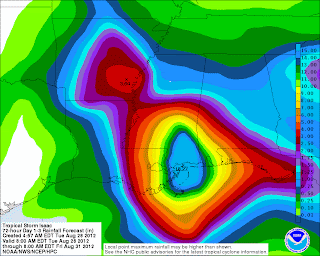
Rainfall will be the biggest issue. Strongest winds and rains are always to the center (eye) and east of the system. Note the rain is forecast to be heaviest to the east of the landfall spot. New Orleans gets off with only 8-12 inches of rain while Southern Mississippi gets 15-18 inches.
Note this image where the convection is finally wrapped around the eye. As this builds, the storm should get stronger.

The bigger problem will end up being rain and flooding. 90-100 MPH winds are dangerous, but they will be confined to the most outlying and coastal areas. There will be widespread power outages, but it should not be total devastation.
NHC preferred track.

Rainfall will be the biggest issue. Strongest winds and rains are always to the center (eye) and east of the system. Note the rain is forecast to be heaviest to the east of the landfall spot. New Orleans gets off with only 8-12 inches of rain while Southern Mississippi gets 15-18 inches.

Monday, August 27, 2012
Isaac very close to hurricane status..
If we are splitting hairs and making an argument for people to remain vigilant in the path of a storm, I'd have upgraded Issac to Hurricane Status at the 4PM advisory. The ability of modern science to see a storm from SO many angles-- satellite, radar, microwave, Hurricane Hunters and the advancement of computer modeling has made data overwhelming. With that, I trust their judgement and in it's proper time it will be Hurricane Issac.

Isaac has been SLOW in developing because of various patches of dry air along its path. There has also been a couple synoptic features along the path that has slowed the process. Ironically, if we are looking at things from a risk perspective, it would be better to have a storm peak over the mid gulf and be on the down side of it's top strength than peak or gaining strength at landfall.
I've attached a recent enhanced sat pic of Issac-- there is plenty of colder cloud tops to the S and W of the center/eye. If those colder cold tops wrap around the center, we could get a period of rapid intensification.

Isaac the enigma!
My apologies to those who read and expect updates from me. My Father's house has an older computer and between the computer freezing up every 10 minutes or so keeping track of my three kids, updates were not just in the card. The lack of cell service at his house sealed the deal.

Isaac the enigma has done everything in it's power to avoid land, not strengthen and be a difficult storm to track via both landfall location and intensity. It missed MOST of Hispaniola and clipped Cuba where it barely was over land BUT never really gained much intensity. Now it's in the Gulf and as of this current update STILL has not reached Hurricane status.
Where is it going?
Well, LAND! My thoughts last week near Pensacola were not bad but it looks to be a tad west of that, likely near New Orleans. And, the angle it is taking looks to be a "worst case" for the city built under sea level. I'm not sold on the current NHC track or timing because it has struggled to be stronger. YES, it could blow up soon-- but there are some synoptic features that could inhibit this. In a worst case, it COULD blow up to a Cat 3, in a best case it's a disorganized mess and is barely a Cat 1. It's going to CRAWL for the Wednesday to Friday time period- moving maybe 100 miles those total days. Flooding will be a HUGE issue to the near and to the EAST of the center.
More updates later today.
Check out http://icyclone.com/ or find him on FB under the same name for updates from his chase.

Friday, August 24, 2012
Friday Afternoon
Model data still indicates that Isaac scrapes part of Cuba-- passes the FL Keys and goes into the Gulf of Mexico. Could end up at Major Hurricane in a worse case that currently seems to be 100 miles either side of Pensacola. FL
On the road and will be at my Dad's over the weekend. More limited access to computer data, but will update when I can.
On the road and will be at my Dad's over the weekend. More limited access to computer data, but will update when I can.
Isaac-- South and weak
Isaac has been an interesting storm so far. While the conversation swirled around where he would cross Hispaniola and the track from there, the bigger concern SHOULD have been it's overall lack of strength. It has been unable to to pull together one main center and as a result has not gain much strength.
We briefly had Joyce, but she's back to a depression.
Isaac- I still favor the southern track. It should start to get somewhat stronger, hit Cuba as a stronger tropical storm and once it emerges into the Gulf of Mexico, it's a hot tub there and it could have a day or two of RAPID strengthening. That's my preferred track at this time but we've not ruled out any other options at this time. I wish I had stated my "target" at that point was Pensacola, FL because it's been fun watching the models trend where I thought they would. With that, models are just guidance and we can expect wild swings in this thing still.
Summary- Isaac scrapes far western Haiti, goes across much of Cuba as a rainy but weak tropical storm and emerges in the Gulf of Mexico early Monday. If it follows the NHC and my preferred track, we could see a Cat 3 in the GOM at some point late Monday/early Tuesday. Anyone on the western side of FL all they way over the LA/TX border should keep keep their eyes and ears open.

Wednesday, August 22, 2012
Quick Isaac Update
Track has been a little north of what I thought-- and on some levels seems destined to bump into every piece of land possible-- hits Hispaniola, scrapes Cuba, near the southern tip of FL and along the W coast of FL. With all the land obstacles in the near future, the best chance we have of seeing this thing become a STRONGER hurricane is if it can migrate west into GOM away from land.


Latest NHC Map--
Will update later with latest guidance and more detailed speculation.
Tuesday, August 21, 2012
Isaac on the docket...

From here, the speculation is does it stay far enough south and NOT get beat up badly by Hispaniola. There are mountain peaks OVER 10k ft on that island and it would not be the first time a 'Cane never reached it's potential due to land interaction. Guidance has shown some variety-and the NHC has marked this as the most likely track.
It will eventually take a NW jog-- and it depends how quickly.
My guess so far is it takes the south side of the "cone" over the next 24 hours and we will adjust from there. US interest from FL SW into the Gulf should monitor at this point.
Here's a quick loop from the GFDL-- crosses the storm over Hispaniola, emerges into the Bahamas and hits in the vicinity of Miami.
http://raleighwx.americanwx.com/models/gfdl/18zgfdl500mbHGHTPMSLgfdlLoop.html
Sunday, August 19, 2012
Cooler and a little rainy pattern on the way..
Cool, rainy Sunday this week with SOME heavier spots were 1-2 inches fell especially to the west of Lynchburg. There was a sinkhole on 81 in between Lexington and Staunton today. I checked the some of the rainfall totals and didn't see anything too extreme so my first guess is this could have just been a long standing issue. However, not having data from this exact spot makes this a big guess.


This pattern will persist for the first few days this week and we will have some chances of showers and thunderstorms through the early part of the week.
The tropics may be heating up. We do have Gordon taking the rare form and move west to east and should be very close to Portugal in a couple days but likely down to just a tropical depression. After that, a system about 1000 miles west of the Cape Verde Islands looks prime to develop into something very soon. This has a decent chance of being a "news maker".
Monday, August 13, 2012
Ernesto chase video
As promised-
Josh Morgerman - a hardcore storm chaser and founder of iCyclone has posted his video from Ernesto.
iCylcone
Cool graph of the barometer from his location--
Barometer drop
Link to his FB page--
iCyclone
Josh Morgerman - a hardcore storm chaser and founder of iCyclone has posted his video from Ernesto.
iCylcone
Cool graph of the barometer from his location--
Barometer drop
Link to his FB page--
iCyclone
Tuesday, August 7, 2012
Friday Storms.
This spring/summer has been above active storm wise for something you would remember--
HUGE hail event in late March that was up to 6 inches deep in places, Derecho event on June 29th that knocked out power to 90% or more of the region.
Friday MAY add to that event. At this point-- the SPC has placed our area under a 30% risk for 25 miles of any specific point. Considering we are 72-90 hours away-- that's a pretty bold call. We've got a stronger cold front moving in, and the deciding factor may end up being how much sun we get Friday. If we keep the cloud cover from the storms Thursday (not likely to be WIDE severe that day) Despite good parameters, we could avoid another significant event.

Tropical Wise, Florence formed and dissipated without much fanfare, as we expected. Ernesto has been all over the place forecast wise, but seems like it will make landfall in the Belize/ Mexico Yucatan region. top winds are around 80 MPH currently and could MAYBE touch 90 before landfall. I've got a friend who is a dedicated chaser and I'll share some of his updated when it gets rolling down there. His website is
http://icyclone.com/
HUGE hail event in late March that was up to 6 inches deep in places, Derecho event on June 29th that knocked out power to 90% or more of the region.

Tropical Wise, Florence formed and dissipated without much fanfare, as we expected. Ernesto has been all over the place forecast wise, but seems like it will make landfall in the Belize/ Mexico Yucatan region. top winds are around 80 MPH currently and could MAYBE touch 90 before landfall. I've got a friend who is a dedicated chaser and I'll share some of his updated when it gets rolling down there. His website is
http://icyclone.com/
Sunday, August 5, 2012
Rainy pattern update--
This should be a cooler and somewhat wetter weak upcoming. I do think the best rain totals and rain coverage is south of our region, but a region wide .5 to 2 inch rain event is likely.
 Latest QPF from the HPC shows minor changes--Best chance for rain will be Monday and then more showery and thunderstorm stuff Tuesday into Wednesday.
Earnesto is in trouble-- has not strengthened as much as thought AND is too far south. Landfall maybe Hondorus and or Belieze. Latest NHC plot--


Earnesto is in trouble-- has not strengthened as much as thought AND is too far south. Landfall maybe Hondorus and or Belieze. Latest NHC plot--

Florence formed as we thought--as it progresses east, likely to NOT become a Hurricane and may just weaken as it goes well north of the Caribbean Islands. I don't see this as much of a threat to anyone.

Friday, August 3, 2012
Maybe some rain?

With our "minor" drought conditions here (there was impact from the heat on local crops-- not specific to drought) we will get a nice break of cooler and wetter weather. We've had a ton of showers and thunderstorms but nothing "region" wide. I can think of 2-3 times this summer where the models showed a decent rain and we got NOTHING or very little. I do like how this looks at this point. As a reference, here is the HPC's rainfall total over the next 5 days.

These events tend to be more showery and the gradient won't look anything like that. However, I like how this looks and think we do see a region wide .75 to 2 inch rainfall over the next 5 days. A little more could be in the pipeline AFTER that.
For those who enjoy tropical events-- Earnesto is fighting it's way through some tougher conditions and should achieve hurricane status later this weekend/early next week. The question is does it run into the Yucatan and just fade out or graze it, end up in the gulf as a more strong threat to the Gulf states region. My take now is I'm hedging more towards the graze into the gulf, but we've got plenty of time. If you're a map person, the NHC has some good easy to read info on their website.
http://www.nhc.noaa.gov/refresh/graphics_at5+shtml/203848.shtml?tswind120#contents
There was a nice flare up of convection near the Bahamas recently and that has slight potential to form but what I'm really interested is the flair up off the Africa coast-- labeled as LIKELY to become Tropical System in the next 48 hours. We should have Florence by early next week.
Friday, July 27, 2012
Stopping by the blog on a summers evening..
Well Howdy,
I must be the WORST weather blogger with the excessive heat and a few incredible thunderstorms that I've done NO updating on. NONE--
My goal is to improve that. I'm hoping to reformat the entire blog into a REAL website, have daily updates and a bit more features. Time frame on this launch is Oct (tentative)
Today's storm looked a little exciting for a minute, but once it approached there wasn't much where I was on Timberlake Road near Lynchburg. Other places had some hail--etc but none where I was.
So, my goal is to get more consistent updates and move away from the blog format. Winter weather is my greatest passion, but I do get pumped up over Severe and Hurricanes. I'll start to add more information on that as well to provide a more comprehensive service. With that, I'd suggest everyone follow Sean Sublette from WSET and Jamie Singleton when a severe event is on tap. For my money, they are two best local FB/Twitter guys. WxRisk.com is worth following on FB-- he does more medium and long range stuff and is "full of personality" as well.
However, a little pre thought about winter. It seems clear that we are heading into an El Nino. If you recall my winter outlook in Winter 09/10 about how a moderate,west based El Nino is best for our region. Breaking that down a little, anything above a +1.2 in regions 3/4 of the Pacific is GREAT for us. The model data is not exact but some guess have it CLOSE to 1.2 but not quite there. (East based El Nino's are another beast as well) Anyways, if you want a decent winter-- just on stats alone that 1.2 places us in the best statistical place for an exciting winter.
Monday, February 20, 2012
Post storm wrap up
Wow, what an event!
It was a forecasting challenge but in the end just was a fun storm to be a part of. It's clear the highlight of the storm was between 5 and 6 PM where .22 liquid fell at the airport in Lynchburg. That was likely a tad above 10-1 ratios, so maybe as much as 2.5 inches fell that hour. I was out with my middle son making a snowman and sledding and it seemed every time we didn't move the sled, 5 minutes later it had a quarter inch on it.
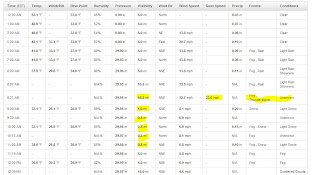
In Lynchburg proper, we really lasted in the meat of the band longer than other locations in our area with another .10 an hour between 7 and 9 pm. Here's a view of the LYH obs--

It was a forecasting challenge but in the end just was a fun storm to be a part of. It's clear the highlight of the storm was between 5 and 6 PM where .22 liquid fell at the airport in Lynchburg. That was likely a tad above 10-1 ratios, so maybe as much as 2.5 inches fell that hour. I was out with my middle son making a snowman and sledding and it seemed every time we didn't move the sled, 5 minutes later it had a quarter inch on it.
In Lynchburg proper, we really lasted in the meat of the band longer than other locations in our area with another .10 an hour between 7 and 9 pm. Here's a view of the LYH obs--

My forecast overall- I'll give it a B. Had I held to my original map, I'd say that was an A. Using models as guidance can be very tricky. As the event was approaching it was clear there would be a 2 part event-- event one was the first push of moisture and it seemed it would have incredible "frontogensis" -- two airmasses collide into each other. In this case, it was the moisture from the sub tropical jet hitting the cold air sliding in from the north. This part of the event was decent- general 1-4 inches region wide but that wasn't the main show. The model data was much stronger on this in the 2 days before the event until that last second jog south in the models.
The second part was caused by the mid level circulations-- 850 and 700 MB low. These are harder to forecast as their tracks are not as exact and where the best banding set up would be somewhat difficult to pinpoint. The late night model runs Saturday night pushed them down closer to the VA/NC border. My concern was we'd about get next to nothing (especially far east) from round one and round two would be more intense to our south.
Round one went as expected and round two slide north vs the model data. About 6.5 inches of the snow in Lynchburg was from that second round associated with the mid level low.
Here are some regional totals-- many are incomplete. If you check the time stamp, anything that is before midnight or so isn't the entire storm.
I expect the LYH total to be 8 or 8.1 (current report is 7.7 but it's incomplete) Roanoke is 5.5, Blacksburg is 6.8 and Danville is 3.
Enjoy the snow today-- 45 for a high today, 55 tomorrow and 60s by Thursday! It will all be melted by late tomorrow except the plow piles.
Sunday, February 19, 2012
Maybe a silver lining--
Tough storm. We went from being on the southern fringe of a northern VA event, to the meat of the heaviest band, to the northern fringe in 48 hours. My concern before of banding sliding to our N has not MAYBE turned into hope as banding is never modeled well 48 hours out and it become a short term, meso issue. As the upper air energy approaches that banding is become more defined a should hit PARTS of our area. That's going to be the show here--
Here is a link to the HRR, a short term new model. This is a " modeled" radar loop. If this happen, this will be a nice little event. Do note the first band brushes LYH to the north and the second COULD scoot just to our SE. Still, parts of our area would do well and there is a little more coming late.
I like my last call-- but this could add a LITTLE bonus snow.
http://rapidrefresh.noaa.gov/hrrrconus/jsloop.cgi?dsKeys=hrrr:&runTime=2012021912&plotName=cref_sfc&fcstInc=60&numFcsts=16&model=hrrr&ptitle=HRRR%20Model%20Fields%20-%20Experimental&maxFcstLen=15&fcstStrLen=-1&resizePlot=1&domain=full&wjet=1
Wholesale changes.
I've never been a fan of the "weatherman can get it wrong" half time time and still have a job. Can an accountant balance a ledger with estimates? If the estimate was $200 and the actual was $1200-- they will be way off. Weather forecasting is the same way- we use the data we have and hope the sample is accurate. This storm had so many moving parts it has been hard to gauge each one. And, as a result we've got to make some changes.
I should have mentioned there was a shot this thing ended up a little more suppressed. I really didn't see it was SUPER viable option, but it would have been prudent. My thinking was 50 mile wiggle room either way keeps us in close to 4 inches of snow. The wiggle was more like 75-100 miles.
Model data has trended south and radar looks CLOSE to that portrayal. The mechanism to deliver cold air (jet stream area) and has shunted it a little faster to our south. As a result:
1. We get less moisture.
2. We needed the heavier snow to overcome the warm ground. I had no issue saying the warm ground doesn't matter as long as the snow is falling a decent clip. We should get some type of a decent burst later today, but before we may have lighter sleet/snow and rain because it's light and we can capitalize on the lower dew points to drop the temps. So, we will have more rain than I first thought or snow that just won't accumulate this afternoon.
Adjusted thinking. May do a map by mid day, not that it helps anyone at that point.
NRV-- 4-6 inches.
Roanoke Valley 3-5
LYH 2-4 with 2 up in Amherst and 4 closer to Altavista.
Southside- 4-8.
In general being Northeast is bad and being South and Southwest is good.
I can see a scenario where the banding still sets up north. Banding is NEVER modeled well-- despite all the changes in the models. As a result, Lynchburg has close to nothing at 5pm, everyone thinks its a bust and the storm strengthens and a band dumps 5 inches in 4 hours. This will have to be monitored. I don't want to sound like Princess Leah, but this could be our ONLY HOPE to get 5 inches in LYH.
We are in nowcast mode-- Model data helps, but radar, water vapor matter more. Feel free to friend me on facebook or subscribe Keith David Huffman, twitter @ VirginiaWx for current updates.
A short term model called the HRR keeps us dry all day, but creates a decent band LATER AFTERNOON-- this would be impressive for a few hours.

A short term model called the HRR keeps us dry all day, but creates a decent band LATER AFTERNOON-- this would be impressive for a few hours.
Saturday, February 18, 2012
Things seem on track for a nice winter event. I specifically wore short sleeves to my my sons basketball game to soak it all in. Overall, model data has held fast. I'd say that we are on tap for a liquid event of .6 to .9 along the 460 corridor from Blacksburg right into Richmond. Precipitation will be MAINLY snow, but the fist 1-2 hours could have some sleet and rain mixed in. Also, I expect a late afternoon early evening lull that could have some sleet and or freezing drizzle falling. Outside of that, mainly snow. Even Danville should do a little better snow wise.
I expect a strong push of mix changing to snow, and a lull later, followed by colder temps and a second push of heavy snow due to the approaching vort going to our south. That could produce some heavy snow rates Sunday evening. Timing wise, the slow down has been about perfect for our region if you wanted a good snow.
What could go wrong?
I have some concerns about the total precipt that the one vort circled earlier that could crush our wave enough to pull us down to a half inch or so of liquid. Also, while I'm not really worried about temps, that's always got to be a thought if we mix more then I anticipate.
What about the warm ground?
Over rated, over rated, and over rated. If it was marginal cold aloft falling to temps at the surface of 33, I'd have concerns. Yeah, it's not going to lay on the road fast-- but grass, cars, benches decks will have accumulations fast. When the "lull" I talked about, you may settle and lose some depth-- let's say you have three inches at the end of round 1, it may condense to 2.5 inches and you get another 4 on the back side. You had 7 inches fall still. With that, temps are very cold-- just above the surface we will have temps at .-5 c at times. It's not going to be a "wet" snow other then the surface temps won't be bitter. I can even see the evening action being almost powder like. Citing examples-- 09, 05, 01 all had events where the temps were well into the 50's the day before. Feb 22 01 I played basketball in shorts and we had a 2-4 inch storm the next day. The bulk came in 2-3 hours in the morning and when it slowed, that snow did NOT melt.
Start times- Far SW around Sunrise-- 10-11 am in LYH. End time? 10 PM far SW, 2 AM East of LYH.
Some mixing and just a tad warmer overall keeps Martinsville to Danville and over to South Boston a little low. Now, when that second piece of energy dives in, they may catch up well.
As for my map, the bulk of my focus is the Blacksburg Warning area. If you're outside that region, shoot me a message and I can look up more specifics in your region. I also didn't do much for NC-- there is some uncertainly everywhere, include those from 40 up to the NC/VA state line. Second wave could cash them in with a decent event.
My thinking as of now. May have to massage a little here or there, but I like how this looks.
 |
| Final call |
Water, water, every where, Nor any drop to drink.
Fun, interesting storm to follow. Model data has now literally done a complete reversal on some levels and some data has suggested we miss the best snows to our SW and even S rather than N and NW.
What's going on?
The overall storm has slowed. We have three moving pieces as shown below. This are the upper air energy, "swirl's" they call them on storms associated with our storm. They are about 17k feet about the ground.
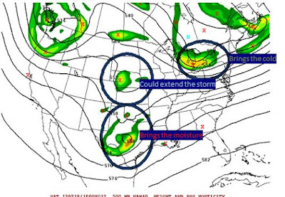
What's going on?
The overall storm has slowed. We have three moving pieces as shown below. This are the upper air energy, "swirl's" they call them on storms associated with our storm. They are about 17k feet about the ground.

Brings then cold--- has raced out in front and will help deliver cold air from the north. From west of the Blue Ridge to north of 460, I do expect mainly snow.
Brings the moisture--Has slowed just a tad and won't bring the goods until later. I can see Lynchburg not starting until NOON now.
Could extend the storm-- one final piece of energy dives in behind our storm and will let lighter snow linger. Depending on the exact timing, this could add a little more snow as it works with the brings the moisture.
I'm going to wait till mid afternoon for full map update. As of now, I like the "let's add 2 inches to everyone from yesterday, except the far north reaches of my map. They likely won't get as much total precipitation.
For the record, don't fret the NWS not issue a watch for LYH. Reading their office discussion, they are still talking about rain starting before sunrise. The slower trend will hold it off. I'm assuming they didn't fully digest the new runs. Not much, if any data shows it much, if any rain after noon. Sleet, maybe but not rain. A this moment, I see LYH getting 4-6 inches on grass, cars and porches, and 2 inches of slush on pavement, etc
Friday, February 17, 2012
If you ain't first, you're last!!
12z Model data is confirming that a colder, snowier solution is becoming more likley. With that, I'm opting to NOT attempt to be the first go bigger, but try to be give an honest presentation of where things sit.
With that, my statement of adding two inches to my first guess seems more and more likely. However, in terms of "wiggle room". I can see 50 miles of wiggle room on the models. 50 mile wiggle north moves LYH from 6-7 inches on the GFS to 2-3 inches. 50 miles wiggle south on the NAM moves LYH into well over a foot (as modeled)
We've got a ways to go here-- I'd expect winter storm watches by either later this afternoon or early Satuday. (Excluding southside)
Full update during late evening model runs.
Is it Raining, Is it Snowing, is a Hurricane-a-Blowing??
Yes! The danger must be growing, for the rowers keep on rowing!!!- Willie Wonka
Challenging forecast on deck--
Literally ALL of the model data has shifted south in the last 24 hours. That's a colder and snowier solution for those of you paying attention at home. The short and sweet version is a piece of energy out runs the storm forces cold air towards us. Associated with that cold air is a stronger jet. This stronger jet also beats the storm up pretty good with a strong jet that comes along with the cold air.
Further complicating this is the potential for a severe weather outbreak. If the thunderstorms develop, which there is moderate risk, if the orientation isn't right it can reduce moisture influx, at least for a while.
With so many moving parts, it will be hard to nail down a forecast-- but I do believe we break the shut out of snow this winter in Lynchburg proper.
The Breakdown- Saturday will make you question whether it will even be able to snow as temps will be over 50. Clouds roll in late and temps fall over night to the upper 30's as rain starts. I think it quickly mixes with snow and sleet, and flips to mainly snow by noon for Blacksburg to Lynchburg. Snow could fall heavy at times for a while and ends late in the evening Sunday. (Lighter snow after 5 PM)
The storm has tended to slow down on the model data and that's a good thing. With that, systems often run faster then modeled. This could be an issue with timing of the cold air-- it's my experience that even if the storm runs faster, doesn't mean the the cold air will be faster. However, we will have tremendous forcing aloft with the cold air pushing down from the south, strong sub tropical jet to the north-- this creates lift and lift cools the air.
My map- disclaimer. I focuse mainly on Central and SW VA-- the father away you get, the less I know about your micro climate. If your in grandma's cabin in WV, I've not studied your area in depth.
 |
| My call as of now! |
With a ton of variability this is not my final call. With that, if the WARMER solution happens, I'd subtract 2 inches in the green and blue zones and ADD some to the magenta. Anything outside of the blue would end as snow, but just a coating to an inch.
if the Colder solution verifies, very possible to add 2 inches in the green, blue and yellow zones.
Subscribe to:
Posts (Atom)