And, a winter review--
Wow, if that storm didn't meet or exceed your expectations you can't place things in proper context. And, it will be all melted by noon tomorrow.
March 25-26 1971 was the last time Lynchburg had a spring storm of that size. The official total of 6.5 inches is a little under the 7.3 from 1971, but when we beat a record that is older than ME (turning 40 soon) you need to be impressed.
Such a difficult forecast where I tried to say that if everything went right,we could see 6 inches. How many times has something gone RIGHT this winter for snow? Each event had small challenges and issues that derailed the event--
1. Jan 17 deformation zone forms a bit south compared to modeled and much of Amherst, Bedford and a small sliver of Lynchburg got next to nothing. Sean Sublette in Midtown had 2 inches while Timberlake road had a good 3.5 to 4.5 inches. I put that down as 3.5 but could justify a 4 or even 4.5 honestly.
2. Mid Feb event-- inverted trough that dumps up to 8 inches over parts of Campbell, Appomattox, Charlotte, Buckingham and even into Nelson County. Tricky, tricky event. I drove down Timberlake and it was Covered with snow from the 460 back entrance near 7/11 and snow free past Lowes. I believe Sean Sublette reported .8 from his house in that neck of the woods.
3. March 5-6- marginal warm temps, early change to snow-- not much backlash. 3-3.5 inches. Didn't feel like that much.
So, this event-- with a bad track record, going more than 1-3 seemed unwise. If you follow me on twitter and FB, I did say 3-5 early afternoon. The overnight went as I expected with 1.5 or so at my place.
Fun event and you may not see this type event, this late in the season for a LONG LONG time.
With that--
My winter outlook--
HERE--
http://lynchburgweather.blogspot.com/2012/11/winter-forecast-12-13.html
I should have included March as I would have went cold (Not this cold, but cold)
Seasonal outlooks are rough because it's part skills, part luck and part luck?? So, I'd say it wasn't my finest outlook (09-10 has that honor) but wasn't bad.
Horrible on December, I'd grade it an F.
I said colder, it was +5.5
Better in January- I said +2 and it was +4.3. January was also very went between 2-3 bigger storms.
Feb-- I just missed a decimal, calling for a -3 and it -.3 :)
No March to grade.
Snowfall-- Climo is 18, range of 13-18 and we have that.
2-4 months were drier than normal- I touched on that.
Temps were warmer than I thought, especially early in the winter. I had banked on colder air and it never showed up-- until march.
I want to give myself a B-, but objectively it's more like a C/C- Getting a snow total close due to a late season 7 inch is more luck than skill.
Monday, March 25, 2013
Saturday, March 23, 2013
Reluctant Blog, reluctant forecast--
I believe this event was mentioned on my last blog March 17th. Great pattern, strong short wave-- end of March??
As I stated, had this been a January pattern and not the end of March, it of been one for the record books. March 5-6 is a 10-20 inch event, a couple smaller ones and this one on the horizon. If it were January 24th, I'd be deciding between forecast 3-6 and maybe 8-12.
But, we are stuck. I've considering blogging but being honest-- the models have STUNK this year and it's made it hard. They keep upgrading these things and before you can work out the kinks for your specific region in interpretation, (especially winter with the temp issues of snow vs rain vs sleet) and just a LACK of events has made it a challenge.
So, model data is all over the place. Some models have been showing pretty snowy solutions and others have been showing SOME snow, but daylight, lighter precipt etc makes me infer it won't accumulate.
I'm still a snow lover at heart and part of my NON blogs was just not wanting to invest in ANOTHER event that will disappoint me. I mean, Jan 25th clipper with an inch was fun, but I expected an inch. Jan 17th rain to snow was fun-- 3-5 inches of heavy stuff and 2 hours of the biggest flakes I've seen in LYH was awesome. Everything else has been a let down.
From a snow lovers point of view--
If everything goes right--
We can see 6 inches.
If everything goes wrong, we get a burst of sleet and snow that doesn't lay-- and then occasional flurries and snow showers that don't accumulate.
As a forecaster-- I feel obligated to share both sides and then make an official call.
As of now-- Roanoke and Lynchburg 1-3, with a little sleet likely as the events start. The biggest part is over by 8 PM tomorrow if not sooner and we just have lingering flurries and snow showers.
NRV into the Highlands 2-5-- mostly snow. Better snow in the favored up slope areas.
Will hit Facebook and twitter harder from this point. Everything else will be really now casting. . The LATEST Euro and NAM have a pretty decent burst of snow tomorrow mid day through dinner time.
*GGEM* as well-- canadian model. If your a snow walk or like taking snow pictures, would be an excellent time.
BTW, no complaining over late March snows. They literally melt the same day. Literally, I would expect most to melt overnight Sunday, event if we get 3-4 inches.
Sunday, March 17, 2013
A touch of winter--lingering.
This is the winter that didn't really want to get started, and now really doesn't want to end.
It's not usually fair to say "What if this were"-- but we've had some pretty strong blocking most of March. Had this taken place 2 months ago-- we'd of had a heck of a winter. The March 5-6 storm likely would have been all snow, and 10-as much as 20 inches region wide. Even with the warm March sun pushing Tuesday March 5 up to 50, it started as sleet in Roanoke with dry and and even the rain here, the first 10 minutes or so had some "slush" in the drops as the dry air didn't allow for total melting.
With that, another minor event possible-- I should of blogged this yesterday, but the kids got me busy playing Mario on the Wii U :)
Cold front has passed and colder air is filtering in--
This is a 100% timing event-- as warm air is being pushed back over the top and causing more precip to fall. If the timing is off, we could get a little more or less than anticipated. Either way, not a huge event. There are winter storm warnings for the same areas that got BEAT DOWN on the March 5-6 storm The warnings are for 4-8 inches. Timing is good, with much falling as night, but as we've gotten closer, the warm air aloft is coming in a tad faster. So, sleet may be a bigger issue on some areas of 81 as well cutting down on the large 8 inch amounts. (Especially east of the Blue Ridge like Charlottesville)
Southside is mainly safe-- rain.
NRV would likely see less than LYH and ROA.
Some freezing drizzle is possible after the main batch moves out and we have some linger moisture in the early and mid morning.
ROA and LYH-- up to a slushy inch of sleet and a little snow. Not a big deal, and certainly likely a school delay NOT needed but I'm sure they will. :)
March isn't over-- and neither is our shots at snow, yet. Data has been hinting around March 25 another "big" coastal low. I know March 5-6 failed due to the lack of fresh cold air-- this storm "may" have it. That's a LONG ways away and subject to much change.
Tuesday, March 5, 2013
NO major changes- 1-81 special, north of Lexington!
Last nights model data went with no surprises..
GFS moved towards the EURO
EURO moved towards the GFS.
2-4 inches LYH and ROA, more just north. Parts of Amherst may see close to 10 inches.
460 is the southern extent of "decent" snows--
We get a TON of rain before hand.
FWIW, Short term model NAM is a tad warm, we don't get much accumulation from that one.
Monday, March 4, 2013
Some thoughts before the evening model chaos
Hard to blog when I, well-- work a real job. :)
This morning I hinted that the 6-14 forecasted by the NWS for Lynchburg was likely too high and they've adjusted everyone region wide down, with highest amounts of 6-10 for Amherst and Rockbridge county.
1. My statement of the ULL needing to touch NE South Carolina is huge-- and this won't happen. HUGE snow option pretty much off the table Lynchburg. Track now is MAYBE just north of 1-40 in North Carolina. If this had very strong cold air, we could deal with this, but in March with no parent high is a no go.
2. The trend has been more rain and less snow. This was obvious before the 6-14 call this AM from the NWS, but it was "watch" not "warning". My guesses have been a bit high as well. One issue is assuming a trend stops. As this as trending more north and warmer, assuming 36 hours this is done is foolish. So, my current thoughts of 2-5 may be high.
3. I need to follow my own rules of things ALWAYS trend north. This was NOT a confluence instance (Like Feb 19th last year) that kept it south, but vort interactions. That's a different breed. Some of the data now makes this a full blow Noreaster that runs up the east coast bring big snows along or maybe just west of of I-95.
4. The 18z GFS showed another way to get close to 6 inches in Lynchburg. The low takes the further north route and we do get decent rains. However, it REALLY cranks up around SE VA and sends warm air WELL to the North of the low. this pushes the snow bands well to the west and even south west where the decent, accumulating snows make it back to close to 460 in our region, especially east of Roanoke.
So, with that-- my current thoughts which I will update later tonight or early tomorrow.
For ROA-
Mainly rain, ending as a snow, under 2 inches 60%
Ends as snow 2-5 inches 40%
Over 5 inches 10%
For LYH
Mainly rain, ending as snow-- under 2 inches 40%
Ending as snow 2-5 inches 40%
over 5 inches- 20$
Danville--
Anything above 2 inches would shock me.
NRV- gets a little crazy with elevation. maybe 2-4 inches.
** Edited to say-- you can see how precarious this is** I can totally see Amherst getting 10 inches in the city and by the time you hit Fosters Fuel on 29 it's 2 inches.
** Edited to say-- you can see how precarious this is** I can totally see Amherst getting 10 inches in the city and by the time you hit Fosters Fuel on 29 it's 2 inches.
Winter Storm Watches HOISTED..
I'm impressed with the National Weather Service from Roanoke- they just went BIG!
Winter Storm Watch western areas 4-8 inches possible (Including Roanoke, Blacksburg)
Winter Storm Watch eastern areas 6-14 inches north of the Staunton River. (Campbell County, Lynchburg north and east)
And, they may go down in flames. :( My confidence is not that high.
It's a battle of the models.
-
1.GFS, NAM, and SREFS: The crank up the low a JUST smidge north and east and we get mainly rain as the incredible snow bands sit somewhere closer to Charlottesville.
2,GGEM, Euro and UKMET are more south with the low and keep a heavy band, especially over northern and eastern areas much of Wednesday.
What do these have in common? The First set upload data in something called 3dvar (3d variational data assimilation) and the second in 4dvar (4d variational data assimilation)
4dvar is an upgraded model and has tested to be superior in the big picture, but has lost some individual events so to speak. The NAM and GFS has both showed the big event at times, but the overall trends have been a NEAR miss. The Euro has been consistent and just varied a little the strength.
What is the differences on a functional level?
The biggest differences is how quickly this storm "winds up" and exactly where. The 4DVAR models are convinced it will be more to the south and west and hang that thing back longer to get us under a good snow band for hours. There are a ton of players this system.
What do you think, Keith?
I'm so glad you asked. :)
Confidence is low. The consistency of the Euro I like, despite being a little south of it's ensembles. (Ensembles are the same model run 50 extra times with minor changes to weed out flaws in modeling)
However, at this time I would have liked to see the 3DVAR group move towards the 4DVAR group. They flirt, but don't commit.
Some of the models literally every 5 miles you head North east out of Lynchburg ads an inch to your total.
My current guess-
Blacksburg and Roanoke 3-6
Lynchburg 4-8
Amherst Appomattox- 6-10 maybe more in the higher elevations.
If the banding sets up a tad south, these could be higher, especially Lynchburg region.
Per the norm, will update this later-- not a lock at all. When banding sets up, it gets crazy-- like trying to guess exactly where a thunderstorm will form.
Sunday, March 3, 2013
This is a madhouse-- Ash Wednesday Snowstorm
Feels like being cloned.
More detailed update.
The devil is in the details. Models that are weaker on the block over New England are further north, while those that are stronger are more south. It keeps the energy suppressed to the south.
I felt great after the 12z runs until the 18z GFS which was more north. The other models are a tad north as well, but the EC is about the same for our region and bit south overall. It has about 2 inches of liquid that falls mainly as snow.
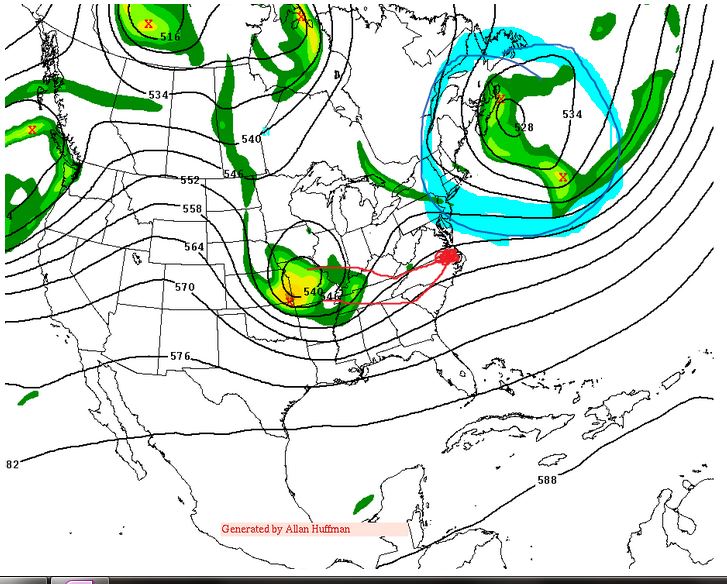
Here's the blocking map I made earlier-- the block and 500mb low (vort) if as modeled on the EC will keep this storm in a great position for us.

Any changes to your thoughts??
1. Despite the EC and UK met staying south, the north trend concerns me. The blocking is strong--a few mets who I REALLY respect and trust are harping how strong the block is. If the block over Canada is as strong as modeled on the ECMWF, we should get a major snow event.
2. It's a lock we get SOME snow. Maybe 2 inches, maybe 12. I'll break down the chances later.
3. Banding will exist-- some winners and some losers. We've had too many events WAYY to high on total precip on the models.
4. Temps- BARELY cold enough in the Lynchburg to Roanoke area. Danville seee's a TON of rain before snow. We won't get the usual 10-11 -1 ratios. It will be more like 7-8 to 1.
Vegas odds-- Snowstorm total.
1. For Lynchburg and Roanoke
2 inches 80%
6 inches 50%
10 inches 25%
15 inches 10%
2. Martinsville-Danville.
2 inches 60%
4 inches 40%
8 inches 20%
As we get close, we will massage these numbers.
If you wanted exact ranges now-- my guess would be
Higher elevations 8-12
Roanoke to Lynchburg 6-10
Southside 2-5.
More detailed update.
The devil is in the details. Models that are weaker on the block over New England are further north, while those that are stronger are more south. It keeps the energy suppressed to the south.
I felt great after the 12z runs until the 18z GFS which was more north. The other models are a tad north as well, but the EC is about the same for our region and bit south overall. It has about 2 inches of liquid that falls mainly as snow.
Here's the blocking map I made earlier-- the block and 500mb low (vort) if as modeled on the EC will keep this storm in a great position for us.

Any changes to your thoughts??
1. Despite the EC and UK met staying south, the north trend concerns me. The blocking is strong--a few mets who I REALLY respect and trust are harping how strong the block is. If the block over Canada is as strong as modeled on the ECMWF, we should get a major snow event.
2. It's a lock we get SOME snow. Maybe 2 inches, maybe 12. I'll break down the chances later.
3. Banding will exist-- some winners and some losers. We've had too many events WAYY to high on total precip on the models.
4. Temps- BARELY cold enough in the Lynchburg to Roanoke area. Danville seee's a TON of rain before snow. We won't get the usual 10-11 -1 ratios. It will be more like 7-8 to 1.
Vegas odds-- Snowstorm total.
1. For Lynchburg and Roanoke
2 inches 80%
6 inches 50%
10 inches 25%
15 inches 10%
2. Martinsville-Danville.
2 inches 60%
4 inches 40%
8 inches 20%
As we get close, we will massage these numbers.
If you wanted exact ranges now-- my guess would be
Higher elevations 8-12
Roanoke to Lynchburg 6-10
Southside 2-5.
Saturday, March 2, 2013
Quick thoughts before the evening models
Just wanted to post a quick map before the evening data. Each model run brings us closer to a REAL solution. A big event is happening as the main shortwave is getting closer and closer and should be sampled better.
Most of the data was good if like big snows. However, the 18z GFS took the more north track and was a TON of rain ending as some snow. More like 2-6 inches rather than the BIG event I want.

I tried fooling with GIMP software and it was not cooperating with me. :)
So, this was done ghetto style on one note.
1. I drew two red lines-- One goes down into SC and NE towards Hampton Roads.
the second line goes across Kentucky, along the VA NC line and near Hampton roads.
These are the two presented tracks for the upper air low. For Lynchburg and Roanoke to get a big snow, we REALLY need the southern track. If it touches down in South Carolina, we are golden. If it takes that more northern track we will mix with rain for a while and it gets more complicated.
2. I drew those blue lines up east of Maine, near Nova Scotia, That is tied into point 1. The stronger, more west that it, the better chance we have of driving that energy down into South Carolina. When the 18z GFS had the more north solution, that blocking was weaker.(There is an upper low tied to that blocking as well called a 50/50 low)
While I liked the 12z runs and think it's plausible, as stated-- the north trend ALWAYS scares me.
Most of the data was good if like big snows. However, the 18z GFS took the more north track and was a TON of rain ending as some snow. More like 2-6 inches rather than the BIG event I want.
I tried fooling with GIMP software and it was not cooperating with me. :)
So, this was done ghetto style on one note.
1. I drew two red lines-- One goes down into SC and NE towards Hampton Roads.
the second line goes across Kentucky, along the VA NC line and near Hampton roads.
These are the two presented tracks for the upper air low. For Lynchburg and Roanoke to get a big snow, we REALLY need the southern track. If it touches down in South Carolina, we are golden. If it takes that more northern track we will mix with rain for a while and it gets more complicated.
2. I drew those blue lines up east of Maine, near Nova Scotia, That is tied into point 1. The stronger, more west that it, the better chance we have of driving that energy down into South Carolina. When the 18z GFS had the more north solution, that blocking was weaker.(There is an upper low tied to that blocking as well called a 50/50 low)
While I liked the 12z runs and think it's plausible, as stated-- the north trend ALWAYS scares me.
Help, I'm stepping into the twighlight zone...
Well, most of the evening model data was promising if you are a snow lover. I tried to stay awake for the ECMWF or Euro and nodded off around 60 hours. Waking up and seeing it was UNREAL.
The Euro was a madhouse-- with literally 15-25 inches of snow from Roanoke to Lynchburg with maybe close to 30 inches in places NW of Richmond.
Don't take this literal-- at all, yet. Potential has certainly grown and we could be staring down a potentially historic weather event. We've moved away from a full phase event where two vort maxes merge near our region and more towards just a strong closed upper air low being pushed south of our region and slowing down due to the stronger blocking. The low gets vertically stacked which means the surface low and upper air low are on top of each other and it's a beautiful event.
Here's a link to an article about the Ash Wednesday storm. This guy was up towards Massanutten, but it conveys how intense that storm was. This storm, 51 years later, would fall on Ash Wednesday. Lynchburg had almost 18 inches of snow from this event that stalled off the VA coast for day and was one of the costliest storms ever in terms of coastal beach erosion.
http://www.glenallenweather.com/links/digest/greatestsnow.htm
What could go wrong??
We are still 100 hours away. There will be changes in the final solutions.. Here's a quick guide to ways to sabotage our winter event.
1. Temp profiles are not horrible, but March with sun and no cold air advecting. In our region of the state, with a late afternoon Tuesday start, it may start as rain. Models are tad warm at the surface and this is always a concern. Taken literal, the EURO has rain in Danville for HOURS after it's snow in Lynchburg and Roanoke. Models TEND to be a bit cold at this time frame in general. So, we could get the BIG event, but too much rain that limits it.
Further, if we don't get quite as heavy stuff--we could get what many refer to as "white rain" where it snows for hours but doesn't lay. The
Once we get under the "deformation zone" we should get plenty cold-- but deformation = banding. I've mentioned before how banding can be hit or miss. This could start and end as rain-- once the storm occludes, it quits making cold air.
2. The upper air low doesn't dig as much. This would cause both temperature issues AND less precipitation. From my experience, you want the upper air low to travel about along 1-40 in North Carolina to max things out here. This is a very strong low and moves from North Central South Carolina NE towards let's say Kill Devils Hill on the Outer Banks. That's an incredible track. Until we hit the 72 hour mark, I'm not sure this willing to bet on a track like that. If it slides NORTH,we are warmer and a less hours under the "heavy" bands. This issue comes in if it DOESN'T dig down into South Carolina- what if it's only North East Tennessee. This can't be ruled out yet.
3. It doesn't slow as much-- Very possible. Spring is notorious for slow moving upper air lows-- and I'd love to see it but this looks extreme on the EC. A faster solution could yield a nice event, let's say 6-12 inches, but not historic.
4. Snow ratio's are horrible. On the January 17th event this year. Near my place on Timberlake rd, we had close to 4 inches from about .7 liquid. So, it was close to a 5-1 ration. Normal ratio is 10-1 or so. Between warmer temps, slower spells that could mix with rain, even if we get the 2.5 liquid as modeled. Ratio's could be as low as 6-1. That would be 14-15 inches of the heaviest concrete snow you'd ever seen in your life.
Vegas odds-
1. Over 2 inches of snow 75%
2. Over 6 inches of snow 50%
3. Over 12 inches of snow 25%
4. Over 18 inches of snow 5%.
I'd love to show the vorticity maps I get from a vendor, but I'm not willing to risk that. However, here is a qpf map from another site I found on FB. It shows one of the 6 hour snap shots of how much precipitation falls in 6 hours. MOST of VA has at least .5, places in the east exceed an inch. The model has 2 time frames like this plus another not far off.

Friday, March 1, 2013
The March 6 hype--
Social Media has made weather forecasting next to impossible. Just about everyone has an idea some of the data shows a potential big snow next week. Someone posts a map, people take it as gospel and chaos ensues.
Here is the skinny..
1. Pattern is ripe for a big storm, but has some flaws and issues.
2. We have decently cold air aloft, but the lack of High Pressure to our north to push in LOW LEVEL cold is an issue.
3. Model data spread is from suppressed in South Carolina to blowing up late and missing our region, but bringing a good event from DC north.
4. Timing is everything-- the exact strength of the blocking to our northeast and timing of the shortwaves will determine this event.
My guess at this point-
33% chance we see an accumulating snow. From that, 10% shot it's over 6 inches and 3% shot it's over a foot.
Key issue is how hard it snows. If we get 12-18 hours of light to moderate snow, we could get ..50 of liquid that only accumulates a slushy inch and is basically melted before the last flurry ends.
Trends last night-
If there were any trends last night, it was for a later phase which leaves us drier as the storm is disorganized before this point.
The key shortwave will be coming ashore later tonight over Western Canada-- that will help. I think by mid day tomorrow we should have a general idea of if this is a legit threat.
FWIW--
The HPC HAD an area of liquid in our region of between .5 and .75. After the model data last night they shifted that east and we are in a .25 to .5 for the period. Not that this is gospel, but it was a step back for our region and a step forward for places to our north and east.

Subscribe to:
Posts (Atom)