Monday, October 29, 2012

Landfall- Atlantic city.

Well, well, well--

Leg one of my landfall at Atlantic City has verified well-  Needing a Philly to just north of Hagerstown and we've won the triathlon.


Crazy storm reports-- Winds on the north side of the storm WELL over Hurricane force gusts-- verified at 94, a few unverified reports OVER 100 in the NYC,Long Island area.

Crazy rains from New Jersey SW to DC area. 5-8 inches common with more on the way. Coastal regions have had historic flooding, beach erosion and much of NYC proper has MAJOR water issues.


My plan was to head up to Lewisburg WV tonight to see some snow, but I've got a recovering sick child. He's better, but needed daddy for the evening. Much of WV looks to be demolished overnight with a verified 8 inch total from a friend in Summerville, WV

For the bulk of our region- occasional light to maybe moderate rain continues. Winds will pick up with gusts over 60 in the Mts and 50 elsewhere. I don't think we see MUCH rain.. under a half inch near LYH and under a quarter inch Danville, Martinsville and Roanoke. These are hedged HI-- I think LESS rain.

IF, IF , IF we can get heavier bands in the region after 2 AM-- it will be mixed with snow. My doubts are we DON'T get heavier bands in.

Snow map on short term model-- sees 2 feet by noon tomorrow MUCH of WV.


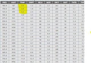
Here is the Lynchburg profile at 6 am-- I highlighted the last three layers, or about 1500 feet of the atmosphere that's above freezing. However, it's only a few degrees, like 36-37 so if it comes down hard we COULD hoover around around 33 with some snow. My hunch is the rain stays BARELY east of us and once it cools we are basically dry. 


Near miss with moisture and temps... don't be shocked to see a few flurries. 


Batten Down the Hatches.

SuperStorm Monday...

Sandy has done pretty much as expected-- she swung out east to near 70 longitude and is not making the shift west. My thoughts were Atlantic City to near Philly to near Hagerstown, MD.

That's going to be rather close-and she's gotten stronger with pressure down to 942 MB.

We've had light to moderate rain region wide over night and the snow change has been sooner than anticipated with snowfall into Blackburg and Hot Springs already.

Rain region wide today with temps steady or even falling slowly. Winds should be increasing as the day goes on.


I'll update with some model data at noon. With the snow change earlier, will have the evaluate. If you look at this radar look..

http://radar.weather.gov/radar.php?rid=FCX&product=NCR&overlay=11101111&loop=yes

snow in the mountains and MAYBE already west of Martinsville.

Saturday, October 27, 2012

Stay on Target....

I see no drastic changes to any forecast you are going to see out there. The bottom line is-- does it land in the Delmarva OR some where in New Jersey. 


I've posted a few times on Facebook that I see a landfall of Sandy near Atlantic City--moving to Philly and then sitting just north of Hagerstown. This doesn't meant THOSE areas will get the worst. More like 125 miles to the SOUTH of the landfall point and upwards of 250 miles NORTH will get big rains and strong and long duration tropical storm winds. Outside the immediate coast of DE and NJ, I don't think there will be "Hurricane Force" winds very far inland. (like as in a few miles) However, Billions of damage via erosion on the coast and down trees, power outages, etc will extend far and away from the "landfall" point. Pretty dangerous anywhere along the coast for flooding and winds.

Sandy actually had a good bit of weakening last night and was down graded to a tropical storm. She's looking better and back up to a Hurricane. I can see it peaking at a cat two before the slingshot to the west as she approaches the coast. 

For the Lynchburg-Roanoke area specifically. 

For our area- we'll have some lighter showers tomorrow into Monday and heavier rains will begin to move in from the NW and E. Don't be shocked if SOME areas-- don't see much rain, especially West of Lynchburg west to Roanoke and Martinsville. 

Winds- Highest elevations will see the worst with gusts over 50, where the west of the world lives will be a duration of 20-30 miles with gusts to 40. 

Snow- EPIC event for the MTS of West Virginia. Still very up in the air where some models pull the storm so far W that Garret County actually changes back to rain on a WARM FRONT out the NE while lewisburg and Beckley areas get 12+ inches of snow. If it takes the PERFECT tract-- Don't be shocked for a remote place like Snowshoe or Davis to get 3-4 feet. 

Where people live like Lynchburg-- We can see some snow showers or flurries Late Monday night and Tuesday. I don't expect any risk of accumulations, but knowing we got a few flakes off a hurricane  would be pretty cool. With a VERY cold pool of air aloft, we could get a decent little burst of snow SOMEWHERE east of the Mountains Tuesday. (Decent for October, NOT accumulating)

My PERSONAL plan is to work Monday and then shoot up to Lewisberg WV Monday night-- My office is  in Roanoke right off 220 and it's 75 miles. Only about 20 of those miles would be snow covered getting back Tuesday morning. 

One crazy snow map-- 19+ inches most of WV and some of the snow sneaks east of the mts. ( Don't be shocked if some place gets a coating to a slopping inch or two Tuesday. 


Friday, October 26, 2012

Still Holding...

After another 24 hours of model runs, there has been a modest switch towards the ECMWF with the more southern route of Sandy. The GFS or American model really had moved in that direction for a couple runs but then went back to a more northern landfall.

Where things sit now.

1. She's coming-- no doubt.

All coastal regions need to be aware and plan ahead. The watches have been extended up past Cape Hattares for Tropical Storm conditions and they should be extended north. Because it jogs west NORTH, I suspect Hurricane watches issues from near Virginia Beach to Long Island or something like that.

2. For our region, some lighter rains out in front of the storm late tonight into tomorrow then the waiting game starts. We need the southern track for the rain to really impact us and the **possible ** change to snow. Ironically, the ECMWF has moved so far south, as modeled the snow actually misses Lynchburg MOSTLY to the south and west. We do get a good bit of rain in the lines of 2-3 inches. Roanoke gets some snow and the NRV and Highlands get a nice snow. (After a little rain) The other models that are further north have the backside snow, just little or no rain.

3. This is still extremely fluid where the smaller changes matter. With that, despite this being a large system, the worst impact will be along coastal regions. The further south the landfall, the better shot of seeing decent rainfall in our region.

4. Snowfall will impact the higher grounds. As said before, the models were CRAZY with bringing heavy snow into Roanoke, Lynchburg, Danville and Richmond. The last 2 runs of the ECMWF have been so far south that Lyncburg actually is too far north and east and the best snows chance past to our west, south southwest and south east. Don't over obsess because as stated before, my suspicions are the model is a little to cold on the back side of the storm.

First map- 12z run of the ECMWF snowfall-- CRAZY 4 feet totals over mountains of WV. This assumes a 10-1 ratio which likely isn't correct (the entire storm at least) plus the snow/no snow line is VERY close to LYH. The snow that falls to our south and east wraps around the city later. I'm not forecasting this, but it's been some of the craziest model outputs ever. Other models have crazy 1-2 foot solutions over the Mountains of WV, with coating to a couple inches east of there. Those are MUCH more reasonable.

This last map shows how if the coldest models verify, how Lynchburg could miss snow, but Roanoke and Danville get snow. Because of the warm core nature of the a hurricane, if you are too close to the center, the warn nature keeps you RAIN. As the storm moves WEST the cold air wraps around the south side of the low. The grid on the bottom shows how the first true shade of blue STOP around the Blue Ridge and show up lets say south of the Staunton River. With that, I've stated before the models are very likely too cold top to bottom, but crazier things have happened. For LYH to have any shot of seeing accumulating snow, Sandy comes ashore near Southern New Jersey and crosses the Delaware Bay and heads into Northern Maryland coming to a point near Hagerstown, MD or slightly north.

Bottom line- if you want to see snow drive to the Ski resorts of West Virginia!

Thursday, October 25, 2012

ECMWF holds again over night-- WOW

I was expecting to wake up and the ECMWF had backed away from the EXTREME event in our area. We know this is already a significant event as it crashed into Cuba as Cat 2 ALMOST cat 3 event.

The EC has answered and said--


Sandy crashes ashore near Rehobeth, DE (Props to my Mom, that's where she lives) and retrogrades as it transitions from tropical to non tropical(moves backwards) and goes over DC and then up in Pennsylvania. 

I'm still very skeptical that EVEN if track verifies as shown that we get the snow as shown east of the Mts. I'm half joking, but I think the MTS may sink a few inches from the weight of 2-3 feet of snow. 


This shows 2 feet plus in the MTS to our west, and close to a foot in Lynchburg. 4-8 inches all the way down to Danville and Richmond. I doubt anything close to this verifies, but WOW on the consistency. 

So, landfall still seems to be somewhere between VAB and Cape Cod and then it moves WNW. The further south, more rain/snow our region gets. There are models that show other solutions with landfall further north. One thought in my mind is the magnitude of the block and how this will impact the overall track of Sandy as she transitions from tropical to extra tropical. Further updates later today!


Wednesday, October 24, 2012

When the statistically best model hasn't wavered..

It may be time to update my blog..

The ECMWF is the best model-- hands down. All models have shortcomings, but when you crunch the numbers it sits on top. It's been fairly consistent with the overall track of Sandy.

It has been consistent with bringing the storm ashore far enough south that:

1. Most of our area gets a decent rain ( half inch far SW to 2-3 inches N and E of LYH)

2. As the storm wraps around, we sit on the SW side of the low in cold air and HEAVY snows fall in the Mountains. Some flurries and snow showers make it east of the Mts.


Here is the snow map- Looking at the model data, this would be HEAVY wet snow. Some of these locations could see HUGE amounts but between the wet nature of the snow and warmer ground I don't think anyone sees 20 inches.

Couple points--

1. The storm is forced NW by blocking to the east and a short wave diving in from the west. Sometimes blocking is under done and as a result, a more southwest landfall is possible. Conversely, sometimes blocking is OVERDONE and a more north landfall is very much on the table.

2. VERY often cold is overdone. It's common in the winter to see a cold snap 5 days out and you think low teens is possible over night and then it's not as strong and it's nowhere near that. So, with that-- even the perfect track that COULD bring a little snow as modeled COULD end up being to warm. Further, models struggle with very moist large systems with latent heat release-- I'm not sure how to quantify this impact just saying that it will have an impact.

3. Rain could have a sharp cut off-- Could see places east of LYH get close to 4 inches and places SW of SML get a quarter inch.

4. We are still 5 days out. With the tropical nature and the more difficult nature of those tracks combined with an extreme block, we may not have something nailed until we see the white of it's eyes.

5. What can you promise me, Keith?

This will be a huge event. I just read a report of 2 dead already from the impact in Jamaica. Further, it may not make landfall to near Boston, but it will be huge for someone. And, some snow will fall on the backside-- I'm about certain Snowshoe, Garrett county and Somerset PA will have accumulating snow.

Sandy is impressive!

The media will be all over this and it will be a fascinating storm to watch-- regardless of it's impact here locally.

Monday, October 22, 2012

The hype of Sandy--

In the era of easy access computer models, about everyone heard of the "possible" mega event In short, a tropical system has formed well south of Jamaica and will move north towards the Bahamas. At the same time, a STRONG STRONG arctic front approaches from the west and a block forms to the north in NE Canada. As a result, the upper energy grabs the tropical system and quickly transfers it to a non tropical storm and as the cold air undercuts and HEAVY snow falls over much of WV, VA, MD and PA. Pretty wild stuff on the modes and about 99.8 % unlikely. It would be a once in 500 year even if anything remotely close happened. 

My long time reads now I love eye candy-- and here is the snowfall map based on 10-1 ratio over the area.


Pretty extreme map-- year, that is 48 inches over that inner circle and the 1-6 inch line is south fo 460. Because of the dynamics of the system, it was near Virginia Beach and ends up near Lake Erie per this model run. Amazing thing is as the storm moves NW our cold air is riding in on south and southwest winds. 


I'd say the odds of a BIG event is likely, but nothing remotely close to this. It's rare, but snow on the backside of Hurricanes does happen as moisture over runs or lingers behind as colder air comes in. There was an event in fall 2005 that had backside snow over central PA from a hurricane and I can recall another storm in the 80's. 

In summary, Sandy will interact with the arctic front and I imagine there will be snow and snow showers on the backside, but nothing remotely close to this extreme run. I think we will miss the bulk of the rain, have some colder temps and Mountain Snow showers after the cold front passes. (In Central and Western VA)


Take out the tropical part and the November 1950 is the closest event to what was modeled last night. NWS Blacksburg did a nice write up on this event in a newsletter last fall. There was a very tight gradient of snow to no snow where Roanoke and Martinsville had 5-6 inches and Danville and Lynchburg had a coating to an inch. 

Sunday, October 21, 2012

Winter Outlooks are on the way..

I'm holding off a little more on my personal because there are many variables that have not resolved itself yet.
Many outlooks I have read are promising if you are a snow lover, and I read a TON of them. However, it's early in the fall to be convinced and the "signals" we look for are not as strong as other years. However, the fall pattern is much different than this time last year.

One key point- snowcover in Eurasia/Siberia has grown rapidly and that's a good harbinger going into winter. It ultimately helps displace the arctic jet AND weaken the polar vortex. With that, I'm not sold on the SUPER snow winter at this point.

Here's a link to an outlook from a Virginia forecaster. DT is a longtime friend of mine and a mix of a mad scientist and Trump the insult dog of forecasting. It's pretty technical but the bottom line is he's leaning colder and snowy, but not 100% sold yet. Enjoy-- DT is on FB as well, he's a good follow.

http://www.wxrisk.com/category/seasonal-forecasts/

Monday, October 8, 2012

October 10, 1979 SNOWSTORM + a little winter talk

September was a very benign month with it being a little on the dry side and temps averaged to VERY close to normal. Lynchburg, VA was .1 degrees warmer than normal and Roanoke, VA was .2 degrees warmer than normal. 

October is a BIG month when making a winter forecasts. Many venues have already released their outlooks and many are leaning near normal to below normal with normal to above normal snowfall in our region. Many of these were made when the El Nino looked to peak maybe close to +1c in regions 3/4 and this is NOT the case as of now. The El Nino has weakened and we could/should end up ENSO neutral going into the winter. (No El Nino or La Nina)

A west based El Nino that peaks as moderate late fall/early winter is our BEST chance of seeing an above normal snowfall winter. I've cited this over and over, but had we reached that point I'd be looking at predicting 150-200% of our normal snowfall. In our region, it tends to trump any other factors in the winter months. With this NOT being the case, we have to weight each global scale and I'm not ready to commit yet. With that, I'm not hedging cold and snowy at this point. One key factor will be Eurasian snow cover-- based on research by JL Cohen states that rapid snow cover increase in Eurasia in October is harbinger of a colder winter in the USA. In simple terms, the snow cover impacts the arctic jet, which weakens the polar vortex. This sounds backwards, but a weaker polar vortex allows for cold air to drift away from the pole while a stronger polar vortex tends to keep it bottled up. 

So, I'm going to monitor the snow cover, keep reading processing data and punt until late month. 

October 10 will be the 33 year annivesary of an amazing early season snowfall in the Lynchburg and Roanoke region. 

In Roanoke, almost a half inch of snow fell with the mounts to the north getting upwards of 6-10 inches. I've read a report of 10 inches up in Covington/Hot Springs area. Lynchburg, VA was hit even harder with 2.4 inches of snow falling. Some places along and near Skyline drive had 12-17 inches. 

What happened?

A slow moving cold front moved across the state while a low pressure formed along the front. The air was VERY cold for the time of year and the combination of a slow moving front along with the "upper air energy" creating strong lift pulled the cold air ALL the way down to the surface. Temps on the 9th had a high in the mid to upper 70's and the temp had cooled to only 53 degrees at midnight as the cold front approached the area. Moderate to almost heavy rain continued to near sunrise (While the higher elevations to our north had mainly snow) and as the upper air approach (with VERY cold air) Thunder and lightning was VERY common as heavy rain switched to heavy snow. VERY impressive for October 1979. 


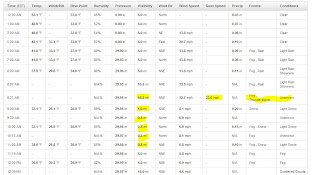
Rain in Lynchburg with thunder and some gusty winds, changes to snow around 8:30. Heavy snow continued till about 11 am with maximum depth of 2.4 inches. 

Another link to some photos from the snow on the east coast.