Thursday, December 30, 2010

Where do we go from here??

As we close out December with ONE very warm day, how does January unfold? My original outlook expected December to be a colder than normal month and the COLDEST of all three winter months. January was to start cool--but end warm and February was to be warm.

December was COLD-- top 5 cold. Most expected a cold December, just not THIS cold. I'd not have expected 6-12 inches of snow region wide, but that's the hardest prediction to make.

At this time, it does appear that we will rebuild the -NAO (Greenland Block) starting early next week and some threats will be in line after that.

Attached is a map that shows heights rebuilding into Greenland (Good sign if you want more cold and BAD if you hate it) Recall that we never got a BIG storm because

1. Lack of Sub tropical Jet due to moderate la nina
2. Lack of PNA ridge-- normal "lack" in la nina winter. We had the Greenland block retrograde into Canada and link up with the lack of PNA ridge, leading to our BIG Christmas snow ( HUGE event in NC and than up the coast)


Note the ridging into Greenland-- eventually  cools us down and the baggy nature of the green colors over the SW tells us there is some energy heading east. Off the cuff, this type set up leads to more of an icing threat compared to snow. (Note-threat, not a forecast)

New Years Weekend starts dry and warm and a cold front comes through New Year's Day NITE--temps being to cool and we wait and see how the pattern sets up for January.

In the FWIW department-- I was reading some research about the EXTREME Greenland block and -AO we had in December. Blocks that extreme are rare, but when they do happen, they usually repeat themselves later in the winter. So, my warmer Jan and Feb COULD be in trouble. 

Saturday, December 25, 2010

Should of asked for a waffle maker this Christmas--- (Threat growing for MORE significant snow)

**Noon Update**
I like the 2-4 inch call after examination of the noon data. Original Call stands.


Wow, I've heard a few forecasters describe this line of work as humbling. Despite being a local guy who does this for fun, after following these models for 10 years and even taking some classes, days like this make me completely understand why this is said. When dealing with Mother Nature, Chaos theory still rules the day.

We've gone from
2-3 days of thinking a BIG snow was possible to
24 hours of thinking an inch was the MAX
to
Currently thinking 2-4 inches is once again possible.

WHY??
 Computer modeling is amazing and addictive. Earlier, we had talked about a "phase" and how the phase had a 6-12 hour window to happen at the right time and at the right place, or the storm will still form, just well to our north and east.

Today, the noon model data came out and some had formed the storm earlier--but the powers that be (Hydrometeorological  Prediction Center) stated that the data had assimilated incorrectly and was wrong. The ECMWF (Again, the proven most statistically correct model) Did not form the storm far enough south and west to change my thinking from **possible** coating to an inch, with only Hampton Roads area getting a decent event.

Late day, the american models that run STILL had the event in our region.

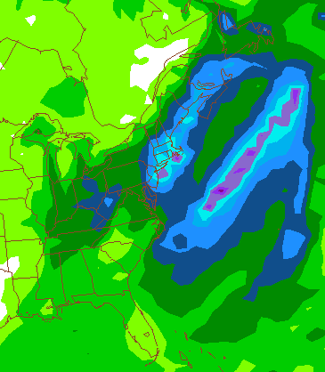
As of 4 am, Christmas day, as Santa is dropping off presents on the west coast, Every model states most of the Central and SW VA region sees a decent snow from this event. All data points towards 2-4 inches ( One could argue for 3-6, but let's start small and stay with it)

Basically, the 2 phasing jets-- the subtropical has remaind a SMIDGE stronger and polar jet has dampened out the first piece of energy in favor of the second piece just behind it and the low begins to explode just to our south and we get a late evening, early Boxing day snow.


Current Radar for Lynchurg and Roanoke.

This should reach the ground towards sunrise. This first batch will slide east with our original coating and a second, stronger area moves in from the SW after 1 PM-- most of the region has snow falling by 4 PM.

General snowfall ideas.

Mt Areas west of 1-81 (Entire event, including upslope snows)
6-12 higher elevations, 3-6 lower, south of the NRV and 2-4 lower elevations north of there.

2-4 Roanoke, Lynchburg--and all the small towns in between.

3-6 Martinsville, Danville, Farmville and Charlottesville.

Hampton Roads 6-12 some mixing issues, 6-12 over most of Delaware with Mixing issues near the coast and 6-12 for my Two favorite nephews in Broomall, PA. (Coastal regions have higher shot both mixing and the highest totals)

Will update later today, as the more intense this storm gets--the better chances we have of getting the higher end of these numbers . This is a "white of the eyes" storm-- won't know the full impact until we see the white of its eyes.  Challenging forecast-- Merry Christmas!

**Quick 7am update before my kids get up to open up presents**
1. It is currently snowing--first wave made it in as expected. Won't be more than a coating, but how awesome is light snow Christmas morning
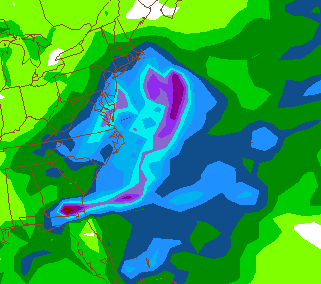
2. Based on WV loop and some other model data, I'm concerned this becomes a much larger event for our region. The MID runs are spitting out over 6 inches of snow. Let's wait until the on hour model data happens, but this could be a MAJOR event.

Attached is the precip output from the GFS ensemble means--the .75 liquid basically runs right up to highway 29-- the operation runs up to .5 precip. This would yeild 5-8 inches of snow across the region.

Thursday, December 23, 2010

Stick a fork in this one--because it's done!

Bye Bye Christmas storm-- Hello, easy travelling.

If you live by a modeled forecast, you die by the modeled forecast. A model called the ECMWF has proven for about 10 years to be the most reliable forecasting tool. However, it will have speed bumps in the road. Just last week it tried to blow up a late weekend storm and brought snows from NC to New England. Again, this time the same model had an EXTREME set up where heavy snows would fall from SC to New England. I have no issue with the National Weather Service and other media outlets reporting this possible storm because of the HUGE impact on Christmas travelling.

You may ask why? I really don't like the old phrase-- Being a weatherman is a great job because you can be wrong half time time. Reality is, people who say that know nothing about the science of meteorology. Some brilliant people have made great advances in this field-- and its truly shown when you look at the data. When you can't control the factors and can't get exact data at the exact time for all the layers of the atmosphere-- it becomes rather complicated. Literally 6 hours difference and a couple hundred miles on the short waves (energy aloft--they often show you picture of spinning clouds if you pay attention during storms) would have created this monster event.

Last winter was EASY-- we had a very strong sub tropical jet and extreme blocking. VERY easy to get major storms and most were modeled out well far in advance. This year, a La Nina, the challenge is greater because rather then having that strong sub tropical jet, we are rely on "phasing" because the sub tropical jet is a little starved for moisture.

The term "phasing" means the jets work together to create a storm. The challenging aspect is that if they phase late--even by 12 hours, they can cancel each other out, move the storm track well away from the threatened area and other factors like that.

There could still be a period of light snow and flurries Christmas day, but this big threat is basically dead (Could see a coating to an inch Christmas day). Cold lingers the remainder of the week and December finishes top 5 coldest month ever. Lynchburg has a shot at the coldest December on record. From there, the pattern breaks down -- the model data hints it may be only temporary before it reloads cold but I'm not willing to budge (yet) from my thoughts that by mid January we are rather warm and February is even warmer.

Wednesday, December 22, 2010

A buzz is in the air

We've been on this storm a few days now--and finally, a solution could be in reach. The storm that has battered Cali with 10 inches of rain and 13 + feet of snow in the Mts is heading east. At the same time, some energy is diving in out of Canada and will phase with the Cali storm energy near the SE states.  IF, and IF this phase happens at the right time this will be a historic storm. Even if timing is 6-10 hours off--we could get graze rather than the full impact. On top of the possible snow--winds will be strong for a long period of time. Beach erosion will be rather bad. Winds rush from high pressure to low pressure...and  there COULD be a 1035 HP over MN while a 970 low sits just east of Cape Hatteras. You won't see 65 MB difference in that time space often other than from a Hurricane.

If the phase timing is off-- the further south and west you sit, the more likely you don't see much snow.

Would start late Christmas day in VA and slowly move northeast-- and really last well into Monday with the winds. Snowfall would meet Winter Storm Warning levels--which is 4 inches. And, the B word is possible, especially those nearest to the ocean.

Map from the Extreme model version--- this is 7 PM Sunday evening. (Miserable Eagles- Vikes game)
A low pressure THAT strong sitting there would have snow falling from Philly down in to NC-- with heavy bands and strong winds.

Tuesday, December 21, 2010

Somebody wake up Bing Crosby--

When the NWS says "likely" 5 days before an event-- take notice. I'm sure part of the extreme lead time is the
nature of the holiday season so everyone has a chance to make and adjust plans, while the other reason is we have great agreement from every model that we see at least SOME snow.

BTW, here is a nice link to the NWS office in Blacksburg.

http://www.erh.noaa.gov/er/rnk/

You just click on your location and it gives you a forecast. The folks our office do a fine job forecasting for our region.

The storm that is beating California to pulp as we currently sleep begins to move east and holds together well. Cold air is firmly entrenched in our region while another piece of energy dives down from Canada into our Christmas low pressure.

The models diverge a little where some (GFS) takes a little while to get the low cranking while losing the storm from Cali and we just a nice 1-3 inch snowfall but Philly North and East get more of a 6-10 inch event (and then some). The ECMWF is a little slower bringing the energy out of the SW, the storm "Phases" a little sooner and we end up with a 4-8 inch event. However, the ECMWF is known to hold energy a little to long in the southwest--so this could be an error as well. COLD storm-- temps down in the 20's.

This looks like a event to be shared by all from Carolina to New England...


This is the QPF(Quanitative precipitation forecast) output from the GFS-- the light green is .10 to .25 liquid
For comparisiong, the shades of blue are a half inch and the pink is an inch and  a half. As always, the QPF maps are the least accurate on some levels for actual forecasting at this time frame, but very helpful is showing what a model is indicating.


The ECMWF model (not allowed to post QPF maps) has a more defined low near FL as its slowed and the northern energy is involved sooner.


That explodes as it moves up the coast-- Goes from 1008 MB to 978 in a day, which is rather impressive.


If you notice over MN--there is a high pressure over MN-- High pressure moving in from the west and storm just to our east means WIND!


Summary--
Snow is likely-- at this point, I'd suggest a snowfall of 2-4 inches for Christmas day over most of our region. The fast solutions bring us less snow and snow starts overnight Christmas eve into Christmas day, while the slower models are not bringing in snow until Christmas day afternoon lasting into the 26th.Windy and VERY cold--so if Santa is bring your kids a sled, make sure he sends gloves and a scarf as well.

Wednesday, December 15, 2010

No drastic changes-- 3-6 inches on tap. My official guess is 5.2 inches.

Best snows straddle around highway 460 thought our region. Very fast mover--- I'm guessing heaviest snows are DONE by 11 AM or so. The speed of this thing will keep accumulations lower.


Start time in Lynchburg after 5 am-- I'm expecting 3 hours or so of rather heavy snow. Frozen ground-- going to be a rough go.

Snow may mix with a little sleet as it ends, especially south of Lynchburg and I do expect freezing drizzle late afternoon and evening.

Let me add--this pattern likely breaks down late month. This has a pretty good chance of being our best snow of the year.

Tuesday, December 14, 2010

Love the one you're with--- snow totals increase for Thursday, chances decrease for the weekend event.

Over Running events are a fun challenge-- with the extreme blocking in place, the amount of moisture, possible mix or change to sleet and freezing rain all have to be factored in. Over running is a term used when there is cold air in place (I'm assuming you noticed the cold today) and some warm air attempts to move it out of the way. Cold air is heave and dense, so it runs over the top of the cold base and makes it precipitate.

The data has taking a strong trend towards two things
1. Cold air holds longer--
2. More moisture.

The most extreme version of this is depicted in the NAM model that gives most of our region about a half inch of liquid, mostly falling as snow (5 inches or so--- and 3 hours of rather heavy snow.) This model tends to over due the precipitation but, I do give it some credence because its a regional model--(covers the US) not a global model that does the entire earth.

Let's start the bidding at 2-4 inches for the night and go from there-- and it still will end as a little freezing drizzle but 90% of the moisture falls as snow. I would not be shocked at all if this ends up as a low level winter storm warning with a 3-6 range region wide.

Snow starts around sunrise Thursday, heavy at times in the morning and over and done by 2 PM.


This map shows the extreme solution with a band of 5 inches running along highway 460.


Event two is less promising if your a snow level--- with the lack of a sub tropical jet, many factors have to come together perfectly to get a good coastal low. There has been a decreasing amount of support from the computer models today-- so I'd downgrade this to highly unlikely. Keep in mind, we don't downgrade because a model says so--but because the pattern as depicted doesn't support a storm.

Monday, December 13, 2010

Cold air is being ushered in--with one, maybe TWO shots at snow in the next 7 days.

December is currently running -10 degrees below normal. WOW---
If you recall last winter, we had historic blocking in the AO and NAO which lead to our many snows. It was this writers belief that we would not see that type of blocking again. And, I guessed wrong.

Some of my "people" in the field hit home on the fact that the NAO runs in cycles and we are in a longer term phase where the NAO will run negative. Last winter, and so far this winter has certainly supported this belief.

The set up--

COLD COLD air is heading our way-- once we dip below freezing over night, its going to be a while before it goes above freezing.

Event 1-

Over running--

What is that? Cold air in place-- flow turns from the SW aloft (think warmer air) and it "precipitates". Some data suggest that this remains to our south while some nudges it into our region. The afore mentioned block COULD keep this thing out of our area--or make it just a minor event.

One model looks a little more ominous with strong lift (lift = precipitation) Here is a snap shot of that left just to our south and west. This is 7 am Thursday morning. This does represent the most extreme NORTH of the model data.

I'd place the odds at 50/50 we see any type of accumulating snow out of this event. Would start early Thursday.


Event 2--

El Nino= Wamer water= More energy in the jet stream..LAST winter.

La Nina= COOLER water, less energy in the STJ This winter.

Despite the cold, we've not had many snow changes because of the lack of energy in the STJ (Sub tropical Jet)

The pattern MAY allow a little more sub tropical jet energy to be introduced to the pattern which COULD spawn a storm that rides the coast. Time is Saturday into Sunday as of now but keep in mind this is attempting to time energy aloft that is still over Sibera.

As a teaser--this is a precipitation output (Disclaimer- the precip forecast are the WORST thing computers model--just using this as an EXAMPLE. Most of VA has between a half inch and inch and a quarter of liquid. If its snow-- would be a decent event.

Now, this is 7 days out. There are no promises, just a tease. And, would be on the exact day of our first big snow from last year, December 18th.

Tuesday, December 7, 2010

Cold, Rain and then back to cold **Edit to say record cold**

The cold will continue through the rest of the week, "warming" a little late week and a system will form in the planes and track to our north and west, leaving us in the warm sector and we get rain. This system will dump more cold air in its wake and leave us cold and dry next week.

Simply put, the pattern right now doesn't look to support snow over the next 10 days. Cold--yes, but this pattern would most likely be cold, warm up, rain, then cold. Despite a record setting - NAO (North Atlantic Oscillation) The Pacific Pattern isn't helping at all--and this "should" hold serve the next 10 days.

** Updated to say this could be record cold. Its been an unusually strong -NAO block and as this rebuilds it will dump bitter cold air over the north east and mid atlantic a few days. Be ready**


Friday, December 3, 2010

The little Clipper that could..maybe?? 2 models come back with a tad more snow.

** Data now snows 1-2 inches likely region wide**

Clippers are fun when they make it to our region--- hard to forecast, but in if your wrong-- an inch or two isn't going to shut the town down for a few days. Someone in my weather community compared this event to the Dec 24th 1999 clipper--was forecast to be flurries and ended up dumping almost 3 inches in Lynchburg, on Christmas Eve.

Computer modeling has come a long way in the past few years, but still has some basic flaws. All models often have a "south bias"--so as a storm gets closer it moves north. Think of the snowfall last winter on Jan 30th. For days they thought the best snows would fall over NC and southside, only to charge north late and drop a foot here and Danville mixed with sleet.

This clipper--again is having those same issues. It trended SOUTH, and south and south to where last night it was going to snow in upstate SC (if cold enough). Now, its slowly tracking north via model data--

I'm attaching precipitation forecasts from the 18z (Late afternoon) and 0z (late evening) of the NAM. While these maps are the LEAST reliable (that's another blog)--it shows what I mean--you can see the nudge north in the heaviest band PLUS its a little stronger. Sometimes clippers develop whats called a strong low level jet--which causes convergence (two air masses running into each other forcing the air up. This causes heavier precipitation.

Top image is the latest run--and the bottom image is late afternoon. Note there is more precip east of the Mts and its nudged north.

Last image-- Lift at 7pm tomorrow. Nice band right up and down the 29 corridor.

Lift = snow. 

I'm expecting 2-3 inches in Blacksburg, 1-2 in Roanoke and Danville and a Coating to an inch in Lynchburg. Jog this thing another 30 miles north and those totals could double.


Thursday, December 2, 2010

Some light snow likely Saturday, cold and dry after for a while--

A clipper type system should impact our area Saturday with a period of light snow and flurries now likely late afternoon and evening. I'm only expecting a dusting to an inch accumulation. I've attached a precipitation map from the early morning run of a model called the GFS--it shows about a tenth of an inch liquid, which matches my thoughts.


From there--cold is the word. Some lows in the TEENS and highs struggling to get past the mid 30's a few days.
Some early indicators show potential 10 days out for a storm. 10 days out means very little other then look for future updates.

Last year, it was an El Nino winter and we had plenty of action in the subtropical jet, this year--la nina, (Colder water near the equator relative to normal) sets up a different type pattern and we tend to not have as much energy in the sub tropical jet. Basically, I would not be shocked if we remain cold and dry.