And, we live in the middle.
The storm appears to be developing as I expected--with big snow totals over much of the deep south. My college city of Chattanooga, TN COULD get 10 inches.
This storm weakens and drys out as it approaches our region. Among the reasons, DRY DRY air-- temps between 5k and 10k feet are at -10 c with dewpoints BELOW -30. So, we could have snow aloft (Virga) for 12 hours or so-- plus the systems upper air support is dying out-- the moisture transport from the Gulf of Mexico is gone.
Next-- Energy diving in from the Pacific NW tracks just to NW and invigorates our storm JUST north of our region. My home base growing up of the New Castle, DE and Chadds Ford, PA region look to get maybe 6-10 inches while NYC to Boston look to get a foot.
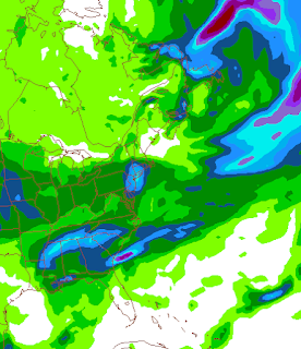
Region precipitation map- note how it swings around most of the VA region.
Our region--
NRV and Southside- 2-4 inches. Southside may get a little freezing drizzle for a period as well.
ROA to LYH-- 1-3 inches.
My guess as of now-- 2.2 inches for Lynchburg.
We are going to monitor trends, sometimes when you have extreme dry air in place and the best moisture intersects the best lift-- no more moisture falls, but the flakes are well constructed (Dendrites) and you can get better snow ratios. our Jan 30th 12 inch event-- this happened last year up near DC. This could mean an extra inch tapped on this storm. (DCA has 6.2 inches of snow reported from 1.3 of liquid. I imagine the liquid is under done, but the it was a 25-1 ratio-- I checked Wilmington, DE and they had 4.3 inches from .20 liquid)

Let me add-- NWS RNK has added some sleet and freezing rain, even up to Lynchburg. Its possible-- won't be a big deal, but very possible.
ReplyDeleteShould have blogged an updated... Missed this event.
ReplyDelete