Tuesday, December 6, 2011

Rainmaker incoming! (ending as snow??)


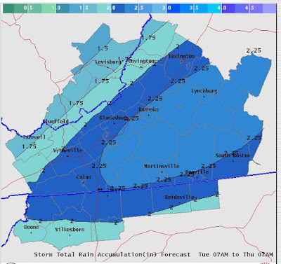
Despite the record setting +AO, a storm approaches and bring a TON of rain-- upwards of two inches. Here is a smoothed map by the NWS RNK. Free plug for them, they are now on Facebook. If you keep up with your news feed they do often link various maps of interest.


The fun and tricky part of this even is that is COULD end as snow, especially in the Mountain Empire, NRV, Highlands where an inch or two is possible and maybe even into Roanoke (Maybe a coating) Lynchburg may end as snow, but the last 2k feet are a tad warmer and I just can see a few gloppy flakes falling. I'm never a fan of these events as often the models are a little too slow pulling out precipitation and as that doesn't always equate to the cold air being faster with the snow. So, I like 1-2 in the higher elevations west of 81-- maybe 3-5 above 2500 feet. If your an 11 PM news watcher-- Wednesday night may have some flakes flying as far east as Lynchburg. The Storm is all but done by 2 AM- even in Lynchburg.

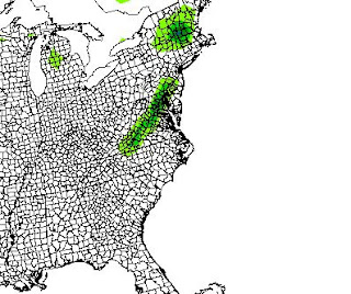
I've attached 2 MAPS-- one is from the 6z NAM-- it's not that aggressive on the western flank with snow and the second is the outlook from the HPC about where they think 4 inches or more is possible. It's pretty bullish, more bullish compared to my current thoughts. 

HPC MAP- Best threat along 81--
 Blue is low risk and green is medium risk of 4 inches.


NAM 6z- 1-3 inches along 81.


For Giggle-- I will show the most aggressive model with snowfall- I think it's too aggressive and 
not factoring in the low level warmth well enough. 
I think this is over done as it has an inch WELL into NC, south of Danville and the 3 inch line knocking at Lynchburg's door.


Sunday, December 4, 2011

Record setting POSITIVE Arctic Oscillation could be harbinger of coming winter--

I know my readers don't always get the technical weather talk and I strive to break it down where it's easy to understand. Back in the past 2 winters-- the Arctic Oscillation has been VERY negative in our very cold times, RECORD negative in 09-10 when we had those major snowfalls. This scale tells us in simple terms whether the cold air will be bottle up towards the north pole or be shoved away from the pole. Currently we have a NEAR RECORD POSITIVE Arctic Oscillation. (It hit OVER a +5, 2 highest reading EVER)

This doesn't mean we won't get any cold - but future events can be hedged by looking at past events. We can get cold here-- one of the years the DAY we set the record "Christmas Eve 99"-- there was a surprise snowfall in the Lynchburg area of close to 3 inches. (One of my favorite surprise events ever- I was tracking the clipper and it was expected to be dry east of the Mts-- the snow started just as a dropped off some gifts for a VERY special family-- was a special day) We can get cold air-- but long lasting cold air is harder to get. Ice events are more likely as there is nothing to FORCE the storm to our South and East.

Years with the record AO+  that took place in December,
Winter 51-52,  71-72, 75-76, 79-80,  83-84, 91-92. 92-93, 99-00, 06-07

Big snow winter-- 79-80

Average- 99-00, 71-72

The rest were BELOW-- some worse than others with 75-76,  83-84, 06-07 being among the 10 LEAST snow winters ever.

The two that are second yea La Nina's-- like this is would be 75-76 (Yikes) and 99-00.

99-00 had a really aggressive winter pattern with 4-5 events in a two week stretch and that was IT. The last even LOOKED to be a big snow event but as it trended closer became a snow to sleet to ice to sleet with 2-3 inches near LYH of ice/slush and more like 5-7 out in Roanoke. The BIG event was a surprise event on Jan 25-- that shocked us all. The synoptic pattern was unique in that there was a negative tilt troff sitting just of the SC/GA coast and a shortwave dug in like crazy and blew up. There was a ton of dry air aloft and so it was literally 10 minutes from 8 inches of snow in LYH to NONE in Bedford. My point-- that was a rare event and atypical for a La Nina winter.

With that, I'd strongly hedge that we pull back our winter expectations. Mts will still get plenty of upslope snows, I'd be shocked if anyone east of the mountains (Roanoke included) breaks 10 inches on the year. I'd increase the risk of an more significant ice storm with low level cold lurking and a bad storm track.

In the near term-- we do have a few shots of cold air incoming, but they won't last long.  I don't see much to think we get into a pattern that looks anything like winter in our region. A cold front passes Wednesday and SOME data has hinted a shot of snow as it passes, especially to our north. Those events are RARE and I don't expect it to pan out.

Wednesday, November 23, 2011

Safe travels today-- big ticket weather event late weekend.

Everyone is likely about on the road now. The weather has been warm a few days, a couple cold and back to warm. This will continue. We've had the exact opposite of the pattern we'd need to get sustained cold. (Not that it's a bad thing in November, but often the November pattern does tip the hand of winter)

Keep an eye on the forecast for Sunday. Pretty intense storm passes to our west will place much of east coast in the warm and unstable sector. (AKA- late fall severe weather likely)

Good link to an article written by Wes Junker- He's likely the best forecaster I know- and it ain't that close from him to second. The article discusses what goes wrong and forecasting and why. Worth the read, even if you don't get all the science part.

http://www.washingtonpost.com/blogs/capital-weather-gang/post/why-are-snowstorm-forecasts-sometimes-so-wrong-part-one/2011/11/23/gIQA4ZfaoN_blog.html#pagebreak


Happy thanksgiving to all! If a pattern change comes- I suspect Dec 15-20 will be the NEAREST time we experience it.

Friday, November 4, 2011

Winter Outlook--2011-2012

I waited until November to get in some data and the data does really help me at all. My sneak peak talked about the QBO-- and I wanted to see the October number and had that drop continued, I'd feel much more confident with a colder and possibly more snowy compared to the normal numbers. With that, my confidence is a lower than normal because the QBO dropped slightly, not a deeper drop.

I really should make a glossary that explains all these QBO, NAO stuff-- if your curious feel free to shoot me an email.

Winter 2011-2012

Slightly colder than normal winter wide--
Snowfall- slightly below LYH to DAN , NORMAL ROA Valley, Slightly above NRV up to the Highlands.

Maybe a decent event of 6-10 inches region wide, the rest will be more in the 1-3 inch range, often mixed with sleet, rain and freezing rain. These events will do much better to our west, hence my logic of normal to even above in the NRV and Highlands.

Snow guesses-

LYH  15.5
ROA 19
DAN 7
NRV   28

Give me a range of 2.5 inches either way on the snowfall. However, despite my snowfall totals being pretty good the past 2 years, it's some educate guesses and some luck.

Temps- compared to average

Dec  -1.5
Jan -1.5
Feb +1

So,that's slightly below normal

Factors- weak to moderate second year La Nina, -qbo (still hedging it drops) longer term pattern of blocking  up north (-NAO and -AO) -PDO (Usually favors warmth, but in second year nina's tend to trend cooler)
AMO- favors blocking as well.

Storm track-this fall has seen quite a bit of coastal storms both via Hurricane tracks and general areas of low pressure. I'm hedging less snow because of a moderate SE ridge-- won't kill the warmth but will allow storms to take a generalized pattern of INTO TN, KY WV region and reform to our north along the coast. That places us in the slope storms of 1-3 inches. I do expect QUITE a few of these storms and once or twice when the -NAO and AO are extremely negative we get 1-2 decent events.

There are some early signs that our December cold pattern is in the genesis stage and the pattern may begin to shift NOV 20th give or take and the cold may be evident by late month. Considering tomorrow is Nov 5th-- we've had WAYY to many snows on December 5th in the past 10 years.

Friday, October 28, 2011

Cold rain with some flakes

Historic event on tap-- but nothing here but a fierce cold rain with occasional snow mixed in. I can see a couple time periods where it cools enough to be ALL snow with huge flakes falling. If this was Nov 28th- I'd be calling for a foot. (Blacksburg, Roanoke and Lynchburg included in this)

Places north of 64 (Stuanton) NE will have a HUGE event-- tons of snow and tree damage. I can see places getting 16 inches with only max accumulations of 8-10 with melting on the bottom. This will extend NE along 81 and curve into New England. This is literally, one of the biggest Octoboer snowstorms on record in the makings.

Thursday, October 27, 2011

If there was an actual "snow meter" I'd have to raise it to 6.5

Two models, the GFS and ECMWF have had subtle shifts in the past 2 days-- one shifted east, one shifted west, both had a weaker storm. It seems like SLOWLY they are coming to an agreement.

It not locked in-- but late Friday evening rain should develop and once it becomes heavy it will mix with or change to snow. High elevations are at the best chances to see SOME accumulations but I'd not be shocked it even close to Lynchburg sees a coating. These storms are tough as it involves upper air energy diving our way and spawning a storm that forms JUST far enough south to throw back moisture into our region. While it's cold enough aloft- 3k feet down as modeled is just above freezing.

This could be a pretty damaging storm to trees up towards Wintergreen, Afton Mt and other places NE along the Blue Ridge Parkway.

Monday, October 24, 2011

If your nose has been twitching-- Could it be "snow" has been mentioned MAYBE in our region??

October snows are rare-- but no unheard of. Oct 1979 had a rather large event that dumped 2.5 inches in Lynchburg as heavy rain changed to heavy snow. Parts of the Blue Ridge- Skyline drive had upwards of a foot or more in that event- Drastic change as the temps near midnight were 53 degrees and 9 hours later we had heavy snow falling-- in OCTOBER.


We currently have a strong short wave ( upper air energy) diving in from the MN region and it spans a storm that spins up and on some modeled data shows rain changing to snow for our area. (Not ALL areas-- seems to be mainly rain S and E of Lynchburg). Time frame on this event is Friday night into Saturday AM.

Here are a couple snow maps-- the first is made by the GFS and shows a strip of snow along and east of the Blue Ridge-- 1-2 inches.
Next, the ECMWF has the storm more amplified and the snow is MAINLY to our north, but-- its a ton of it!
Wild stuff!


I'd guess that there is some type of "abnormal" even happening, but I'm not convinced we see here. Hot Springs has a good shot, up into the Mts of WV, PA and NE from there- if anything changes, I will certainly update.

Sunday, October 9, 2011

Winter Sneak Peak

I'm not ready to fully commit to a winter outlook-- so, let's consider this my preseason outlook. I'll lock and load it in by Nov 10th or so as there is a little more data that I'd like to see before a final outlook.

This will be the 3rd winter I've made a public outlook-

09-10 was pretty cold- called for 30-45 inches of snow region wide, colder then normal and targeted the end of Jan/ Feb as the BIGGEST snow threats. 

LINK to the forecast

Good outlook, A grade IMHO

10-11
Went cold December-cold breaks in January, 5-10 inches of snow for the winter.

Good call, not cold enough but it's foolish to go -9 or whatever the mean December and broke the cold to early. Part of the cold hanging on longer was a spike in the PNA (PNA= ridging or trough on west coast--ridging on west coast translates to trough on the east coast-- troughs are characterized by colder and stormier in general terms.)

Good outlook, I'd put in in the B+ range. 


Winter 2011-2012

We are in a second year La Nina that is in the weak to moderate range. 

La Nina's in general feature colder then normal Decembers that warm once we move into January and usually have  mild February in our region. This happens because the mean trough shifts west and get riding along the SE coast. 

Why I'm not 100% locked in yet--

1. Something called the QBO or

 Quasi-Biennial zonal wind Oscillation


  -- we have a tendency to see more high latitude blocking. High latitude blocking. This blocking helps keeps cold air on our region. The QBO has dropped to just below positive and I'd like to see a stronger drop when the October data comes out. Further, we have a a split QBO where the 30 MB is negative but the 50 MB is positive. 
When the QBO runs negative (based on wind direction WAYYY up in the sky which was discoved in 1883 when Volcano Krakatau erupted and the ash circled the globe in 15 days on strong westerlies at this level and further research developed from there)

2. Recent tendencies of Artic Oscillation and North Atlantic Oscillation to run negative.- This links the first point-- this is the high latitude blocking I was talking about. 

3. Solar flares-- reading some research on this and they've some what established a lag time between low solar flares and impact on global weather patterns. I'm still chewing on this one in my hierarchy  of impact- this impacts the amount of blocking as well. 

This summary- our entire winter depends on how much high latitude blocking we get. If we lack the blocking-- it's going to be a warm winter. Conversely, if the blocking is stronger, more dominant we could be colder/more stormy as the mean storm track slides east putting us in the colder, stormier pattern. 


Early Thoughts--
I like the idea of a colder pattern developing late November and lasting 3 weeks into December. Pattern relaxes into mid January and the block emerges again Mid month to early February. Pattern relaxes again with another "possible" block 2nd week of March to the end of the month. 

So, starting Dec 1-- Cold 3 weeks, warmer 3-4 weeks, cold 3 weeks-- warmer/relaxed 3-4 weeks, colder march 10th or so but that's all relative to seasonal averages when you get into March. 

Snowfall-- this is what people care about most, yet has the highest element of luck as you can't really time short waves. 

La Nina's tend to low on sub tropical jet - think of those big snows in 09-10 where the tv guys showed this STRONG wave that came from the equator. So, we are dependent on the northern (polar jet) to provide storms. Unless we get strong blocking, we won't get a HUGE storm. 

Can we get a huge storm-- Yes! The polar jet gets forces south and becomes a part of the subtropical get provided the short wave (spin the weather men like to show on sat. shots)  If we DON'T get that via timing or other issues the "colder events" will be light on the precipitation, like .25 of an inch to maybe .75. Issues with the strorm track will always have mixing as a risk. I'm leaning we can see a 4-8 region wide snowfall-- good event, not historic or memorable and a bunch of 1-4 inch mix messes. (More in those events in the Mts to our west) Good risk of an I 81 special where the heaviest snows(BIG EVENT) run up 81 and tails of quickly east of there due to mixing/rain. 

The cold snaps will have a bit to them and the warm breaks will seem GREAT comparatively speaking. - Snowfall total ideas-- I like a pronounced gradient from NW to SE where I can see Harrisonburg and Staunton being a good bit about normal, Blacksburg and Roanoke very close to normal, Lynchburg slightly below normal and Danville to Richmond below normal. This is caused by a storm track that approaches from the west/Soutwest and the low ends up in eastern TN or SW West Virginia and jumps to the coast east of Virgina Beach or even the Delmarva/ NJ. The snow is usually slower to slide east and the mountains due to dry air and the Mt regions have snow for HOURS before even Lynchburg does. Once the moisture gets in the air is warming aloft and while Blacksburg/Staunton have already had 4-5 inches, Lynchburg gets a quick inch and it changes to sleet/freezing rain. Danville gets some sleet and freezing rain that changes to rain. 

Expect a final call with more exact data, comparable years by November 10th. 

Friday, September 23, 2011

Winter Outlooks are trickling in--

Keith Allan is a "Professional Forecaster" from the DC region-- His outlooks at time have held "heavyweight" status to those who read and follow him. I'm going to share the forecast for this year plus some raw data from what he did in years past. I have a resource who has his forecasts all the way back to the 80's. I'd define his finest moment as the legendary winter of 1995-1996 where he called for 45 inches of snow in DC for the winter and there was 46.2.

His forecast is DC centeric, but I do read it and extrapolate what that should mean down in our region.

Snowfall for DCA:20-24".

December:+1
January:+2
February:-3

** Even though it's a math 0.0 he says the 2 out of 3 months being above average gives it a mild lean.

He thinks a 4"+ snow event in mid December, then quite mild until very late January and then turning very cold. He thinks a 6" to possibly 12" event will occur in February and well below average temps. He believes the cold will continue well into March. Even with a mild January he thinks there will be 1-2 freezing rain/sleet events for DC area.

Analogs:1946-47, 1966-67, 2006-07.


From Keith--


I'll let you grade him on his own merits once the winter ends. Longer range forecasting is some skill and some luck. With that, I'm hedging the first half of winter is "colder/snowier and the second half is milder/drier. 


His past years--
ACTUAL NUMBERS IN PARENS

2001-02

DEC: +2 (+6.0)
JAN: -2 (+6.7)
FEB: +3 (+4.5)

Overall: +1 (+5.7)


DCA SNOW: 10" (3.2")


2002-03

DEC: +0.5(-2.3)
JAN: -1(-3.8)
FEB: -3(-4.4)

Overall: -1.2(-3.5)

DCA snow: 20-25"(40.4")


2003-04

DEC: +1(-0.3)
JAN: -0.5(-4.3)
FEB: +2(+0.1)

Overall: +0.8(-1.5)

DCA snow: 12-14"(12.4")


2004-05

DEC: +2 to +3(+0.6)
JAN: +2(+1.2)
FEB: -2(+1.5)

Overall: +0.7 to +1(+1.1)

DCA snow: 14"(12.5")

2005-06

DEC: -1 to -2(-3.1)
JAN: -1 to -2(+8.2)
FEB: +3(+0.5)

Overall: -0.33 to +0.33, but call for slightly below normal(+1.9)

DCA snow: 25"(13.6")

2006-07

DEC: +2 to +4(+4.7)
JAN: +2 to+4(+5.8)
FEB: +2 to +4(-7.2)

Overall: +2 to +4(+1.1)

DCA Snow: 8" (9.5")

2007-08

DEC: +2 to +4 (+2.3)
JAN: +2 to +4 (+5.1)
FEB: +2 to +4 (+2.9)

Overall: +2 to +4 (+3.4)

DCA Snow: 10" (4.9")

2008-09

DEC:-1.0 (+0.8)
JAN:+1.0 (-3.3)
FEB:-2.0 (+1.7)

Overall: -0.67 (-0.3)

DCA Snow: 25" (7.5")

2009-10

Dec: +3 to +4 (-1.6)
Jan: +0.5 to +1.0 (+0.4)
Feb +3.0 or higher (-3.9)

Overall: +2 to +3 (-1.7)

DCA snow: 10-12" (56.1")

2010-11

Dec:-1 (-4.9)
Jan:+1 (-1.2)
Feb:-2 (+3.7)
Average:-0.67 (-0.8)

Snowfall DCA:20-24" (10.1") 


Some people just read patterns better-- he's never revealed the method to his madness, but ENSO isn't a HUGE factor as shown by many years. 


For our region--


06-07 was warm till Feb and once it got cold, the storms still tracked will to our north. We had one minor sleet storm, one 3 inch snowfall and ONE ice storm. 


66-67 was a good winter snow wise-- with a MAJOR snowfall region wide on Christmas eve-- 6+ inches in the NRV and Roanoke and over 10 inches in the LYH region. Over 30 inches of snow fell that winter, with + falling in December. 


46-47 was a a snow winter with almost 30 inches region wide. We had three 8 inch snowfalls in late Feb lasting into the end of March. 3 separate snowfalls of 8 inches. 


Take it for what it's worth-- 


My outlook should be out by mid November at the latest. 

Sunday, August 28, 2011

Home from Hampton

I drove up to Hampton Roads region to "enjoy" the storm. A good friend from college lives up there with his wife and daughter and they "sponsored" me by letting me sleep at their home. The storm was rather large with the impact felt far from the center-- our worst conditions were actually late AM Saturday vs late evening with the EYE was only 50 miles or so to our east.

Wide reach-- wide damage. I've never heard a good reason why they keep it as a hurricane as long as they do when NO surface obs show hurricane strength winds. (I'm sure there were some over SE VA, but that's about all) Not to downplay this storm, it dealt a huge blow to many, but not many observations outside show hurricane winds.

Here are a couple videos-- They are set to public, but I can embed them for some reason.

http://www.facebook.com/video/video.php?v=10150358106272059


http://www.facebook.com/video/video.php?v=10150358110137059&comments

Friday, August 26, 2011

All systems go to "Rock you like a Hurricane"


Just heard this song on a lead in on a radio show-- haven't had something that "tacky" since the Tampa Bay Buccaneers cheer team did a dance to it while playing the New Orleans Saints 2 weeks after Katrina devastated the Gulf Coast. Having said that-- being a weather fan, I do like this song. 

The storm track seems to be set in mud-- I don't think there is much to shift it WEST. Showers may reach Lynchburg, HIGH doubt anything reach Roanoke. You may notice a breeze, but nothing out the norm. 

Landfall will be someplace between Moorehead City and Cape Hatteras. It should be close to or just on the coastline heading towards NYC-- so for all those in points in between, it's going to a rough 24 hours. Regions closest the shore/water will have the worst winds. Rains will be 5-10 inches for those nearest to the track. It's been rather wet from the Philly region north, so even wind gusts of 50 MPH could cause some bad tree damage. 

Quick update later-- I'm possible heading to the Hampton Road area for some "Hurricane Chasing"

Thursday, August 25, 2011

Early AM Irene thoughts


I was tempted the last few days to start writing about Irene, but the model data became LESS ominous for region. While I am rather interested, my interest was NOT quite enough blog. There's been a slight jog west and it's going to be a HIGH impact event EAST of 95 in Virginia. 

Brief review-


It was rather clear Irene would form and have a good threat to make landfall on the USA. Most of the model data tried at one point or another to pull it into the Gulf of Mexico. Looking at the overall set up, it was clear this was not an option. Model data began to shift east and I really thought that the Myrtle Beach area would be in the landfall region. My personal error was assuming that the east shift on the model would stop. That is NEVER a safe or good assumption to have. The models had trended at one point just about was a total whiff for the NC region (Landfall wise, not impact)

For those who wonder WHY the models struggle with these fine details. Short waves, (energy aloft) approaching the US Pacific NW were hard to gauge along with their potential impact. It's hard to quantify an impact when you don't have a good gauge on the strength. Secondly, there is a ridge to east of the US. (I think most heard the term Bermuda Heat Ridge before) The model data was a tad to strong ( Strength= HEIGHT-- ridge was not as big as anticipated) For people who like to "blame" weather man for NOT being accurate-- this is like trying to be an accountant and neither given all the receipts or all the incoming payments. You simply can estimate, but won't be "accurate".

The NWS has added extra " information" into the computer models by way of extra drops into sky over the east coast and Montana to fill those gaps. This has lead to better sampling and a slight shift WEST.

Where is she going?


When the model data was making landfall near Charleston, SC-- that would have been a big ticket item for our region.(Lynchburg/Roanoke) We would have had near Tropical Storm force winds and rains of 3-6 inches region wide. As it moved to a landfall near Hattaras, we'd be breezy, maybe a shower east of the Blue Ridge. As the data has maybe shifted west, places east of the Blue Ridge MAY are getting close to a more substantial rainfall event (Maybe 1-3 inches and a tad more windy/breezy)

Landfall will be somewhere between Wilmington NC and Cape Hatteras as a Cat 3-- I expect it to peak as a cat 4 sometime today. Still a pretty wide spread on landfall but that should become more clear later today.  From there it heads N and depending on the interaction with a shortwave from the W it will move NE, N or maybe just west of N for a while. Any place east of Richmond along the 95 corridor will have SOME to MAJOR impact. Coastal regions will have the greatest impact-- for obvious reasons.

It should hold together hurricane strength winds for a LONG while after landfall-- especially in coastal regions where there is less friction from the land.

This is the ECMWF run-- it's the most left landfall and brings landfall near Moorehead City, NC.

The furthest west option currently on the table-- brings the rain VERY close to the Blue Ridge.  Any further west jog brings more substantial rain to our region. 

This is a 500mb (18000 ft or so) map in motion. It shows a short wave diving
in from the NW and pushing IRENE just west of due north. This is the furthest
west of ANY other guidance currently. Click on this image to see it in motion.


My current thoughts would say that landfall is just east of this depicted model and the worst of the conditions stay Richmond east. Lynchburg may see a half inch of rain from showers, Farmville maybe 1-2 inches and much worse conditions Richmond east. Hampton Roads/VAB gets Hurricane conditions.

 My friends and family up in Delaware/Philly region=
Expect a pretty nasty event- Flooding rains along the lines of 5-10 inches. Winds inland will be sustained at 50, gusts to hurricane force and coastal regions (Near my Mom's in Rehobeth Beach) winds will be sustained at hurricane force, gusting to maybe 100mph. 

Model data should continue to improve today as we get that extra information added- will update later this evening. 

Link to the National Hurricane Center's website-- has some cool maps estimating winds, etc. 


Friday, July 15, 2011

Still kicking

Heat, Heat, Heat-- Humidity.

Summer weather-- loving enjoying the outdoors and pool, but the heat has been horrible. Watching ANOTHER nasty heat wave next week. (July 20-26 or so) Enjoy this weekend as it's about as close to perfect as you can get for summer with temps in the low to mid 80's.


Tropical Weather-- Haven't had much yet (Minor Arlene event)-- should be a fairly active season that starts to kick up in the next 2-3 weeks.

Monday, May 30, 2011

SevereWx and my lack of updates-and some information on the Joplin Tornado.

To say that this has been an active severe weather season is quite an under statement. We've had our share of pretty intense storms that have impacted our forecasting region. My person favorite was the April 28th morning thunderstorm that dropped the visibility  to .5 of a mile at the Greater Lynchburg airport. Comparing that to snow-- visibility of .5 of a mile is moderate snow, approaching about an inch an hour. Terms like "It's really coming down" would be used. In rain-- that's some heavy rain. We actually had a .2 of a mile visibility reported at 7:46 AM and between 7:40 and 7:52 we had .62 of an inch of rain. That's about the heaviest rain I've seen. One six minute cycle had .37 inches of rain-- WOW!


My updates have been LOW and it's by choice. This is just a hobby to me-- BY choice, I don't let myself jump in feet first to the severe weather. If I ranked my favorite events-- WINTER event wins, Hurricanes are second and Severe comes last. If I allowed myself, I could get obsess with ALL three, but I willfully limit myself. I've got a career, children and just general life balance that is needed. My spider senses do start tingling so to speak when these events are incoming, but my sanity and just being a normal guy supersedes in this case. I'd always throw out a facebook status if there was a critical storm heading our way, but the day to day

 For those who don't have him-- Sean Sublett is on facebook and twitter and is incredible at updating for our region. If you've not "liked" his fan page-- please do and he will take care of you with various updates during severe weather.

Many of you know I am a counselor by trade-- did that type of work 10 years. Part of me is an extremely sensitive and caring person who hates to see human suffering. I truly have to watch myself when they show those videos of the just horrible carnage after these huge events as it BUGS the life out of me to not be able to do much. Yeah, I give to the various charities but it hardly seems enough.

I've been very involved in an online weather community currently hosted at www.AmericanWx.com. The short story is a ton of us found each other on some message boards in the mid to late 90's-- and finally found people who were not meteorologist but just LOVED weather. We built a community-- found REAL mets to help enhance the place and it's been a fun 10 years. One of the "regulars" lived in Joplin, MO  only three blocks away from that intense E5 from last week. His pre and post reports were pretty amazing and I thought it be worthwhile to share this information.

The Joplin Tornado was a one in a million perfect event-- the SPC only had a 10% risk of severe storms and pretty much everything that could have gone wrong did. I hate seeing the 142 ish death total. So sad and so many tragic stories. This example just shows WHY we need to heed warnings, even if it seems like we are crying wolf. This guys is an extreme weather hobbyiest like me and literally was only spared because the tornado was 2-3 blocks away.


I'm cutting and pasting this-

I'm guessing about 3-4 minutes.

I think at 5:17 I posted:

"nd there go the sirens, rotation just NW of here."

This was the 2nd couplet that formed and not the actual tornado I don't think. This slid off to the north of me.


Then at 5:27 I posted:
"Pitch black out, couplet nearly on me... Joplin, MO"

This was the 3rd storm and the EF-5 couplet. It rolled through about 3-4 minutes later.

After I posted that, I looked out west and saw the lowering, then a minute or two after that, heard the rumbling. 


This is his FULL report-- I've highlighted a couple lines that hit me. 


This is what happened as I recall, the times may not be correct and it may not have completely happened how I remember it but this is what I remember.

We are very used to having tornado warnings in Joplin. The first instinct of everyone when they hear the sirens is to jump up and go outside to look for it. It's even a joke between me and Wx24/7 that once a storm enters the Springfield, MO CWA, they'll issue a tornado warning for it no matter what.

I had been watching the HRRR all day Sunday and noticed that it was developing the very last storm over Joplin but nothing farther south. The helicity was scary crazy as well. I thought this was maybe just the HRRR being flaky until I saw the storm develop over SE KS and that it was moving SE.

As I remember it, the parent supercell storm that was moving SE developed a couple of cells on it's SE flank. These storms went from nothing but a small blip to a storm in no time at all. SPC mesoanalysis was showing 5000 SBCAPE. The last images other than the base velocity radar image I saw was the LFC and LCL heights, which were both 1000 over the area.

As the storm(s) were approaching, I heard constant rolling thunder and lightning. I was watching the initial parent thunderstorm, it had an unorganized couplet that was rather large and I knew it would slide by to the north of me. South of that another couplet was developing on the second 'blip' that had popped up. This one was farther south than the first one but was still really unorganized. I do believe both were Tornado warned. Then suddenly a third storm rapidly developed south of those storms. A tornado warning was issued that included my area and this was the one that produced the EF-5 tornado.

I watched it go from no couplet to a big bad couplet right over me in a few minutes time. ( I just watched the video that someone posted that showed how quickly the tornado went from a tiny rope to a giant wedge and I'm amazed.) I looked out the window to the west and the sky was pretty much black, much like how it looks when the sun is out at your location and there is a storm some distance away, only this time it was cloudy where I was. There was a lowering which was probably part of the wall cloud. It gave off an orangish hazy looking color against the black sky.

The sirens had gone off for one of the other tornado warnings, but they were going off a second time as well. It was then I heard what I thought was rolling thunder... only this time, it got louder.

I listened to the 'rolling thunder' get louder for about 5-10 seconds before I figured out that it was not thunder. I looked up towards where I heard the sound but the blinds were closed so I decided to get in the only safe place which was a closet before the windows blew out. As I turned on the closet light, the power went out. I was not really expecting an EF-5.

The sound was exactly like what people compare it to, a freight train. It was a loud roar, and it had times where it almost sounded like it was growling. The winds at my location were from the north or northwest because I heard the air screaming in the garage door, it screamed, stopped for a few seconds and then screamed again and then the roar got quieter so I ventured out.

I looked into the rest of the house, no glass was broken, still had a roof. I decided to look outside and despite having a tree that fell over, most of the other trees had no damage. It was now foggy outside though. I suspected I had just been through a weak tornado. I went outside and the first thing I smelled when I made it outside was the smell of freshly cut trees or wood. I thought that was a little strange, but some neighbors trees had broken limbs so I thought it was from that. The roof had sustained some shingle damage but nothing really bad.

I came back inside and I turned on a battery powered radio because I was wondering what the rest of the city was getting or what had happened. It was then I heard that St. Johns Hospital was 'leveled' (a report that was not true, although it had sustained heavy heavy damage) I was like.. whoa that's not good. It was around that time I heard firetruck/ambulance sirens. These sirens ran constantly from right after the tornado hit at around 5:40 PM until midnight. They also ran a lot the next day as well.

I walked down the street, heading to a local church (there's almost one on every corner here) and as I was walking that way I noticed a lot of trees down on just the next street over and the damage got progressively worse. People's privacy fences had been blown over, but this was nothing compared to what I saw at the end of the block. As I was walking I noticed the smell of natural gas, it was getting stronger the closer I got but I just had to see. People had gathered at the church and it was being used as some sort of local triage for minor wounds. I kept walking until I reached the end of the block where everything to the south of the intersection was completely destroyed. I looked down the street and I didn't recognize anything and I realized I could see much much much farther than I could before. There was a lot of traffic that was being turned around there and I didn't want to interfere with the rescue work so I returned home.

 I didn't sleep at all that Sunday night, the days events, the sounds, the thought that I wouldn't probably be here if the tornado was three blocks closer, all kept replaying in my head.
I let the rescuers do their thing on Monday and it was raining most of the day, but on early Tuesday morning I walked back down there and down the street, and I almost could not stop walking. The entire area looked like it was a landfill. On my left, a car parked in the 'garage' where a house would have been but there was nothing but a slab there, water gushing out of a broken pipe. On my right, another street where nothing remained but debris. On the ground there was a St. Johns medical braclet from someone.

The streets were marked by wooden signs spray painted with the street name. "Haz gas" was spray painted on a piece of wood next to a gas meter, a couple of guys pulled up to check and make sure it wasn't leaking still, it was, so one of them phoned the gas company to tell them it was still leaking. The area was being patrolled by police officers from the area and from other counties farther away, but they didn't have much to say or didn't care I was there since I was on foot.

I ran into a lady who had brought a camera to take pictures, she told me that the State trooper guarding the intersection had told her that she had to see it. Pictures don't really do it justice though, people who have lived here all their lives and are older get turned around and lost because there are no landmarks left since it's just a debris field. It reminds me of a post-apocalyptic scene but it's real life. I probably stood on top of a hill and looked around for about 10 minutes at everything, how far I could see and where the damage path was then I returned home.

I decided to go back on Wednesday, a little later in the day and people had returned home to gather their belongings. There were also rescue workers in the area. I saw a boy and his mother on the 2nd floor of what was left on their house. It didn't exactly look safe but nobody was stopping them. I heard an insurance adjustor talking to a woman as another woman was inside what was left of their house attempting to gather whatever she could. I saw a man sitting on the back deck of his destroyed home, holding his head. I looked down and saw that a bunch of debris had gathered down in this valley and rescue workers were there, attempting to find people in the rubble I guess. I felt uneasy and like I was intruding so I decided to return home.

The last trip down there I took this evening. They had cleared away a bunch of the trees. The road was blocked by electrical trucks working on the electric lines, I didn't want to disturb them so I just watched them work. There was other equipment working in the area as well, no heavy equipment yet though.

There have been helicopters flying over for the past few days. I don't remember what day it was but there were 2 blackhawk copters from the National Guard on patrol then two A-10's flew by. I'm not really sure what the point of all that was and most of my neighbors thought it was really stupid. It's not like they were protecting us from some kind of invasion or something.

The city has a curfew in the disaster zone from 9 PM to 6 AM. You can't be in the area after that time. They were going to make people get permits, but they ran out of permits pretty quickly so they just decided to beef up security.

This radio station did a great job of locating people and getting information out there:


Link of the tornado blowing up in a SHORT time.


Various stories about individuals- the HS story is the worst.


Doctor's first hand account.

Dedicated thread at AmericanWX.com about the Joplin tornado.


Pretty amazing events-- always love reading the goodness of man despite horrible circumstances.


Monday, April 4, 2011

Nice morning, Windy this afternoon, Severe tonight

Highs will be 75-82 region wide today with winds developing out of S and SW --  Gusts could be in excess of 40 MPH.

A strong cold front hits our region later tonight-- later this afternoon and early evening, MS, TN and AL are under the gun. Don't be shocked to see reports of tornadoes down that region. The risks here are more confined to strong gusty winds, heavy rain and MAYBE small hail.

Keep tuned to media outlets for updates on the severe weather. If you don't have LynchburgWx on twitter-- add please and I update on Facebook directly- Keith D. Huffman

Friday, April 1, 2011

Winter Round Up---April 1

With the early spring snow threats-- I decided to wait until all those threats were over to "grade" my winter outlook.

Tough winter both on a long range outlook and even on the day to day storms and weather, the model data struggled on many levels.

Here are my initial thoughts in the 10-11 winter outlook.

http://lynchburgweather.blogspot.com/2010/11/winter-outlook-2010-2011.html?showComment=1288745159520#c437893978100543863

Season Temp. Forecast +2 above normal

Seasonal Snowfall 5-10 inches. (Same forecast for Roanoke, 2-5 inches for the Danville region) 10-18 inches for the NRV, The favored high elevations of the region get more due to upslope snows. (AKA, places were I doubt anyone will read this blog)
Higher risk for ice storms. 

Monthly breakdown temp bread down

December-

-2 below normal

January

Starts cooler but ends warm

+2

February

+4
Still has some colder outbreaks, just warmer overall.

As the long wave pattern adjusts to spring, March will feature rapid swings (Normal to some extent in March) with a higher then normal risk of wintry weather.


** My over all ideas were NOT horrible, just the cold was MUCH more extreme, Region wide, we were 7-9 degrees below normal for the month of December. The shift in the overall pattern became apparent in late December but the switch wasn't made until Mid January and the cold lingered most of the month and we averaged between -1 and -3 degrees below normal compared to my predicted +2. February did flip to a mild pattern and we were region wide 2-4 degrees above normal. 


Snowfall-- Very good in the NRV to ROA to LYH. Danville went well over and this is due to the pretty the extreme cold first half of winter favored souther and eastern regions. Virginia Beach has 2x the snow totals of Lynchburg and Roanoke.  While this is a crap shoot on some level, I believe this is a level of skill involved and the past two years I don't think you'd find a better local "snow guess" for the winter. 


Over all grade?? I'd take a B maybe a C+. The biggest stink was the EXTREME cold in December. Reality is no one in the right mind would forecast a -8 departure for a month. BUT, Had I gone extreme of let's say .-4 I'd be much happier with my forecast.


The Good-- Snowfall totals, overall idea of first cold half-- focused on December, DRY all winter and Warm February. 


The BAD-- Not cold enough in December, Pattern change was much more delayed in January. I thought we'd lose the cold mid month and it was more like late month. The overall numbers are REALLY skewed by the extreme cold in December. The two week delay in the flip really hurt my January numbers. Really no major ice threats. This goes hand in hand with the COLD being TOO cold and suppressed the overall pattern the first six weeks of winter. I'd have to check, but I can't recall only 1 day of freezing rain-- December 16th. 


I'm going to skip a "spring" outlook but will release a summer outlook by the middle of May. This will included an Atlantic Hurricane Outlook, Regional Temps including estimates of days over 90 (When it gets really nasty hot) and dig into if this drought condition gets better or worse. 


Tuesday, March 29, 2011

2 more threats of rain, with maybe a little snow.

We are in the middle of a crazy late season cold and stormy spell-- despite our system not really panning out as anticipated, the threat THIS late was rather interesting.

A system approaches our area tomorrow-- and again the higher elevations to our NW may get some accumulating snows. From Lexington north, up 81 East to the Blue Ridge may get a coating to maybe 3 inches at the highest elevations. 

Again, the parade of storms continues and storm approaches Thursday-- same set up, different day where the highest elevations have a shot to get some accumulations. 

Both tomorrow and Thursday have the chance to see some flakes flying in the Lynchburg/Roanoke region-- but I anticipate the best shot for more then flakes in the air will be at the highest elevations.

I won't be shocked if either tomorrow or Thursday has a heavy enough burst to coat the ground with snow for a short time in ROA/LGB. 

Sunday, March 27, 2011

Ya Blew it boy, you REALLY blew it (Krammer voice)

Last nights event was HORRIBLE-- Yeah, I stayed low but NOT low enough. Around 11 PM I figured we were toast-- hoped that band I mentioned via twitter would pull it through for an inch, but between the warm ground and the sleet mix it just wasn't in the cards. Models are guidance and nothing more. One key issue that modeling doesn't handle well is convection on the south end of storms. There were severe storms riding through AL and GA and in effect that robbed our moisture for our snow event. This is a well researched area and they can even gauge the impact based on the angle and trajectory of the storms, but it's hard to quantify the impact on total precipitation.

What killed us was a lack of total precipitation and nothing more. Most models ran between .40 and .75 or so consistently-- and at 10 PM the NAM which lead the way dropped us back to .20. We ended up with .16 total liquid.

There is another system dropping to our south late tonight. With our luck-- watch this one do BETTER compared to our system of failure last night. Galax to Danville has the best shot to see a coating to an inch.

If anything more important develops-- I'll update. Stormy and cool pattern for the next week or so with 2-3 shots of rain .

Saturday, March 26, 2011

Final thoughts before game time---

Fun late season event-- and basically harmless. There's not really going to be enough snow falling to cause any tree damage, the warm ground will melt this fast and despite me being certain it is going to snow, the total amount is a little uncertain.

I'm not wavering on my call of 1-3 for MOST areas. Blacksburg, Roanoke and Lynchburg along 460 will be in this zone. The southern line of an inch will be south of Gretna line, heading SW towards Max Meadows. The best accumulations will fall above 2k feet NORTH of Roanoke- Lexington, Stauton, Waynesboro, Hot Springs-- those locations. These places could see 4-6 inches.

In the lower elevations the inhibiting factor for 4-5 inches is a little mix and very wet snow the first couple hours.

The models have varied enough that there certainly is a chance we get a little more or less then anticipated-- and of course I will update as needed.

Late evening **Snow** Update *Sat am update*

Saturday AM update-- NWS out of Blacksburg side with me and upgrade our region to an advisory to 1-3 inches-- up to 4 in the Blue Ridge.

With the the time change--- weather model's are running a little later and the bottom line of that is I'm staying up another hour. VCU has 2 minutes to lock this up so I can sleep.

The NAM and GFS have run and the data hasn't changed much. The GFS hints that there could still be a sleet issue for a while and the NAM is still the outlier, putting down almost 3/4 of an inch of liquid from this system. I expect Roanoke and Lynchburg to end up with maybe .4 give or take .10 of total precipt falling during this event.

This is only a "big deal" because it's coming on the tails of some great weather and late March snows are rare around here. I can't 100% rule out over 3 inches in the 460 corridor but it's unlikely.

I like my original call-- 1-3 inches Blacksburg to Roanoke to Lynchburg with some sleet and snow grains likely mixed for a while Danville Martinsville MAY see some flakes and sleet with a coating. The BIG winners will remain the Blue Ridge areas just to our north with 2-5 inches, maybe a 6-7 inch total from Hot Springs or Afton Mt.

Friday, March 25, 2011

Rare late season snow becoming more likely--

March 30 2003-- a heavy rain switches to a driving heavy wet snow. Roanoke to Blacksburg had 4-8 inches. Lynchburg had 5+ inches fall, but only a 2 inch max depth. At my Forest home-- we had an inch, a lull which allowed it to melt and another 2 inches that accumulated.

This is the last latest snow in our region. In April 2007 we barely missed a late season snow that coating the ground from NE NC-- Mebane NC had a coating.

Same set up as before-- The cold has been trending a smidge colder, but the models do want to punch a warm later through between 7 and 10k feet. This is a tremendously cold air mass so even when this happens, the snow would partially melt and fall as snow grains rather than pure sleet. When I examine the layers of the atmosphere and see that in theory Roanoke and Lynchburg are supposed to change to sleet before Richmond-- usually this indicates this warm air push is not only very likely, but often will occur sooner than modeled.

Brutally cold day Sunday for LATE March-  temps may struggle to reach freezing once the snow starts, even with a strong late day March sun.

My best guess now is start time between 10 PM far west to 2 AM far east overnight Saturday into Sunday.

Martinsville to Danville-- rain, mixing with sleet. Sleet could coat the ground.

Blacksburg, Roanoke, Lynchburg-- could have a little rain to start, but snow-- changing to snow grains and sleet ending as flurries.  (Snow grains look like rice) 1-3 inches.

Jackpot-- Lexington to Hot Springs to Harrisonburg to Waynesboro into Charlottesville-- 2-5 inches, best accumulations at the highest elevations. Would not be shocked to hear a 6-7 inch total from Afton Mt or some other elevated location.

We are about 48 hours out from this event-- so it has some wiggle room to change. I'm always leery of the "north trend" the models often display. In terns of wiggle room-- we don't have much because Danville starts as rain and changes to sleet as modeled now well into the event. 60 miles isn't much of a jog in 48 hours. Having said that-- there has been remarkable consistency in the models for days now. Still, I've seen the north trend OVER and OVER in years past-- sometimes the models never even show it, but it takes place anyways.

As a result, I'm in full storm mode-- blog updated 2x a day until this event passes by.

Thursday, March 24, 2011

Sharply colder weather on tap-- with a side of white ??

Crazy to think that we've had some great weather the past couple weeks and in the blink of an eye we MAY be looking at a late season snow/sleet event. But, alas-- spring time.

Reality, we've been playing with fire a while because there's been plenty of cold air on our side of the globe, just no blocking to force it south. Enter the block and we've got a legit shot at something over the weekend and MAYBE again next week.

This is a quick heads up, but I will elaborate later. Cold front drops through or region and stalls to our south as a storm forms along it. If the cold air settles as far south as the NAM/ EC we'd have a good shot at some snow/sleet and rain--  Timing looks to be Saturday night into Sunday. This could be a wet system-- but with the warm ground and sun  angle -- a slushly inch or two is likely the best we can do. Some data also has hinted as sleet being the predominant precipitation type. We've got about 60 hours until game time.

Friday, March 11, 2011

So, you're telling me there's a chance??

If something does come of this-- it will be a million to one.

The model data has been all over the place. ( Putting aside that guidance showed between 2-3 inches of rain in Lynchburg with the storm Wednesday and Thursday and we got a meager .65 inches or so)-- there has been SOME event hinted at on the data for a week or so.

Some days, there has been NO storm, some days-- Models made a MAJOR storm.

Slowly, it seems there will be a storm.

Could it be SNOW??
Well, I don't usually blog that much over rain, so YES-- but I highly doubt it. Since this blog is often used to speculate I don't mind throwing this out there.

Basically,  HP is sliding to an ideal spot for our location and a short wave consolidates at the about best time and fires up a decent event. The forcing is supplied from the closing off upper air low and a sinking cold front. If you've been reading me a while-- lift= precipitation.

Temps are very marginal and its still 3 days out.

My gut says we get a storm but its about 100 miles north of shown-- and temps are warmer. Waynesboro, Harrisonburg and those places may see a decent late season snow.

For the record-- some data I just checked out showed between .5 and  1.25 inches of liquid over our region with a decent path of 1-5 inches of snow in that. Temps are horrible the last 2k feet or so-- hence the lack of snow from all that precipitation. Ironically, the storm putters so slow because there isn't much of a jet stream speed wise as of now-- that it actually warms up aloft as the storm unfolds. So, if some places do see snow, it may end as rain.

As of now, anywhere below 2k feet-- expect rain. Those higher elevation places COULD get a get something-- rain switching to snow. We've got plenty of time to watch this event--

Tuesday, March 8, 2011

Flood Watches Hoisted again--

Another late winter storm will impact our region starting Wednesday. The rain will begin Wednesday afternoon and will be rather heavy overnight into early Thursday morning. Region wide totals-- 2-3 inches, with maybe a few spots ending up with more.

With the good rain over the weekend, rivers still running high from the rain on Sunday, and likely more rain falling this time a more potent flood event could unfold. Again, the highest prone regions will be along the rivers and the low lying areas.

Wednesday night will be a pretty raw, nasty night with temps in the low to mid 40's and a breeze out of the NE.

The great issue is that we certainly need the rain. As we predicted in our winter outlook, this was a rather dry winter and any rain is needed.

Monday, February 28, 2011

Tornado Watch starting at 1 PM

First of the year---

Pretty powerful set up, especially this "early" in the year. Meteorological spring does begin tomorrow--

I expect a powerful line of storms to approach our far west regions by 2 PM and begin to move east. This could be impacting the area between 3 and 6 PM. The Watch is currently in effect until 4 PM-- looking at some data, I suspect this will be extended, especially areas to our immediate east and south, guessing until 7PM.

Keep your ears and eyes open to local media and the NWS for the latest updates.

Sunday, February 20, 2011

So close, yet so far away

Extreme temperature gradient-- Common in late winter-- especially in La Nina winters.

I've been watching a storm for about a week that is another two part event. Part one is underway-- from MN to NY a big swath of snow with some sleet and ice. Max snow will be over a foot in some places. This is riding along an arctic front that is sliding DUE north to DUE south. A second piece of energy rides along and some of the latest data pushes snow ALL the way down to Charlottesville-- maybe a couple inches, while at the same time NO layer of atmosphere here is even below freezing.

I'm not sold yet on the extreme far south, but if you recall this photo--- if that 500MB low is a little SW, this is very plausible.

I'm glad I'm not forecasting from DC to PHILLY-- some places in that region have a shot of 6-8 inches of snow and some may get none. The model data is split..but the ECMWF has consistently been south. As a result, I'd bet that much of the DC metro region gets 2-5 inches of snow with someone making a run at 8 inches. (Maybe Leesburg??) This is not set in stone and some fluctuation in the data is likely.

Friday, February 18, 2011

Get these clouds out of here!

I'm hoping we max out today temp wise, which would be mid 70's--- looking at the skies which are somewhat cloudy as of 9 am-- it isn't a good thing. Winds are out of the west and this should help with the temps, but ideally we want these clouds out of here FAST. Clouds o' plenty to our west, so I'm a little concerned the clouds hold us ONLY into the upper 60's.


Looking into the future-- the word will be gradient. There is plenty of arctic air up in Canada, but we also have a strong ridge to our south. Ridging to our south often means WARMTH while the pattern is allowing the cold to come dangerously close to our area.  My idea of a snow event near the Mason Dixon line Monday night and Tuesday is on the table-- every once in a while the computer models will push that system south and try to make it snow here.

I don't expect this to happen--- but I can't totally pull if off the table. I'm attaching a map where I've labeled the pieces of the storm. For the next two weeks-- we are going to be caught in this battle between a decently strong south east ridge, but plenty of cold air in Canada and some physical mechanisms to get it close to our region.
My initial hedge is we stay on the warm side mostly--- but this will have to be watched.

Thursday, February 17, 2011

Won't hit 80, but 70 in February is very nice. Watching next Monday/Tuesday for cold and MAYBE.....

Blogging about 70 in February isn't the most exciting thing ever-- even the possibility of 80 was more fun. 70 isn't that rare down here in our region but 80 is hard to do. After the first preview of 80-- the models slowly backed away from the idea. We should reach the low 70's Friday region wide.

We step down temp wise-- 70's Friday, 60's Saturday, 50's Sunday. After Presidents day, a shot of cold air is heading our way. Some of the model data-- the ECMWF 2 nights ago and the GFS last night want to ride a storm along this cold front that COULD bring some snow to the area. Just judging by the normal bias of all the models, I would be that the 5 days out, the best chances for an accumulating snow are closer to the Mason-Dixon line, but I'm not ready to rule it out 100% at this time.


I'm attaching a complimentary snow map--already shows the best snows well to our north, with some of our region getting a coating to an inch or two. With the general trend in models to nudge things north with time, I'd the best snow chances are along the the Mason Dixon line.


This is a fairly strong shot of cold air-- it just depends how far south the cold can push. The storm is riding along the arctic front.