Our HP leaves and since the storm is now a WEDNESDAY event-- the cold air is our biggest obstacle. We cool enough for snow only due to a truly dynamic system. Storm forms in the Gulf of Mexico and heads towards the South Carolina Coast. Rain breaks out over most of the region including the Mountains. Mountains change to snow a little quicker simply due to the elevation. As the 500 MB low moves into a favorable position, rain rapidly changes to snow from the mountains east. Thermal profiles drop to right near freezing from about 5k feet down making this a TOUGH event. A couple degrees too warm and it snows, but hardly accumulates. This type of event has the potential to have 3-4 hours of VERY heavy snow.
What can go wrong?? While I'm convinced the storm will bring needed rain, if the 500 MB track is wrong, we will not get as long of a period as snow. I've listed 2 inches as the low side-- which seems reasonable as of this time. Also, intense bands could set up-- where place A sits under a band for 3 hours and gets a nice event while region B sits on the outside and gets minimal accumulations.
Any significant changes in the track, strength and speed of the 500 mb low will change our forecast. I've slightly adjusted it north compared to model data as is now.
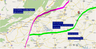
Only changes made to the outlook map is moving Roanoke to the 2-8 zone. Elevation will be a factor-- so just outside Roanoke city will do better.
 |
| Early Morning 1/24/2011 for the 1/26 event. Click to enlarge. |
Let me add--
ReplyDeleteWhen I talk about the hit and miss nature of this event. Some of the early morning data shows 3 inches in Charlotte, NOTHIN in Hickory and 9 inches in Greensboro.
What a wild winter it has been for us this year., Nothing is going easy. every system has its quirks. I like the map though, nice job on the blog too
ReplyDelete