If you recall last winter, we had historic blocking in the AO and NAO which lead to our many snows. It was this writers belief that we would not see that type of blocking again. And, I guessed wrong.
Some of my "people" in the field hit home on the fact that the NAO runs in cycles and we are in a longer term phase where the NAO will run negative. Last winter, and so far this winter has certainly supported this belief.
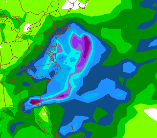
The set up--
COLD COLD air is heading our way-- once we dip below freezing over night, its going to be a while before it goes above freezing.
Event 1-
Over running--
What is that? Cold air in place-- flow turns from the SW aloft (think warmer air) and it "precipitates". Some data suggest that this remains to our south while some nudges it into our region. The afore mentioned block COULD keep this thing out of our area--or make it just a minor event.

I'd place the odds at 50/50 we see any type of accumulating snow out of this event. Would start early Thursday.
Event 2--
El Nino= Wamer water= More energy in the jet stream..LAST winter.
La Nina= COOLER water, less energy in the STJ This winter.
Despite the cold, we've not had many snow changes because of the lack of energy in the STJ (Sub tropical Jet)
The pattern MAY allow a little more sub tropical jet energy to be introduced to the pattern which COULD spawn a storm that rides the coast. Time is Saturday into Sunday as of now but keep in mind this is attempting to time energy aloft that is still over Sibera.
Now, this is 7 days out. There are no promises, just a tease. And, would be on the exact day of our first big snow from last year, December 18th.
No comments:
Post a Comment