Monday, January 24, 2011

Nothing but a chilly rain and suddenly BOOM, its heavy snow

The model data is trending exactly where I had hoped. First half of the storm will be to warm for snow. I had held out some hope that we might cold enough, but not it's in the cards.  The storm has trended SLOWER as first thought were this could be a Monday event and now its a Wednesday event so our cold air support is gone. We are totally dependent on the storm to make its own cold air.


Surface low from the Gulf of Mexico across east NC to near the Delmarva. It is a little disjointed from the upper air low but does drop between .25 and a half inch of rain. As the upper air support approaches we flip to snow. Its taking an ideal track as modeled. It doesn't have to do that--so there is some open chances this changes. We have plenty of wiggle room from the south--as some of the data first plaster Winston Salem and move it Northeast at us.

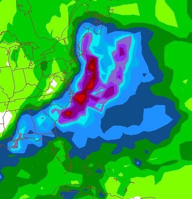
Between a half inch and literally an inch of liquid can fall in the snow band-- considering its wet snow, 4-8 inches. Attached is a graphic from the model output-- it can be hard to read. First column I've marked is surface temps. Second is temp at 5k feet and third is liquid that falls.


Surface temps are JUST above freezing, mid levels are JUST below freezing. I'd estimate that from the
1.07 liquid that falls in these 12 hours, .80 is snow. Because its a wet snow, let assume it falls as 8-1 ratio and that
makes 6.4 inches. 


The air is chilly and raw. As the upper air low approaches from the west, the air cools, which had been running from about 35-40 degrees from 5k feet down rapidly cools. The light drizzle suddenly has huge rain drops mixing and rather quickly the rain becomes heavy. The TV  breaks in and announces 8+ inches has fallen in places in North Carolina and heavy snow is now falling in Blacksburg, Roanoke and Martinsville.  Perhaps a quick rumble of thunder and suddenly a flake of snow appears. Quickly, more and more snow mixes in and suddenly it all snow. Surface temps drop to 32 and flakes the size of pancakes are falling. Heavy snow lasts for 2-6 hours. While flapjacks no longer fall from the sky, such large flakes, the size of silver dollars are not often witnessed around this parts.  With the wet nature of the snow, everything is plastered. Trees branches that stand tall in the sun now scrap the ground under the heavy weight of the snow.  As quickly as it started, the snow has tapered to just flurries.

This upper air energy is similar to the March 1-2 09 event. That event was much colder and we had snow on the front side. The upward motion in the clouds was so great that before the second band of snow came in--we had 20 minutes of graupel where the fast upward movement precluded the snow growth.

Pic from that event-- this is in the two hours were 5 inches fell.

12:30 AM March 2, 2009. 

Will do a full update after tonights model data-- as of now, our odds for 4-8 inches sits at about 60%

Like a winning three point shot at the buzzard---

As we get closer to the event-- it is slowly coming into focus. Challenging event to say the least and really, we won't truly get a true read until about 24 hours out. Sometimes I break down model data by model, from this blog forward, I'll just describe how I think it unfolds. Model data has about settled on a storm track-- its just the amount of moisture and the exact temps we have to deal with.

Our HP leaves and since the storm is now a WEDNESDAY event-- the cold air is our biggest obstacle. We cool enough for snow only due to a truly dynamic system. Storm forms in the Gulf of Mexico and heads towards the South Carolina Coast. Rain breaks out over most of the region including the Mountains. Mountains change to snow a little quicker simply due to the elevation. As the 500 MB low moves into a favorable position, rain rapidly changes to snow from the mountains east. Thermal profiles drop to right near freezing from about 5k feet down making this a TOUGH event. A couple degrees too warm and it snows, but hardly accumulates. This type of event has the potential to have 3-4 hours of VERY heavy snow. 

What can go wrong?? While I'm convinced the storm will bring needed rain, if the 500 MB track is wrong, we will not get as long of a period as snow. I've listed 2 inches as the low side-- which seems reasonable as of this time. Also, intense bands could set up-- where place A sits under a band for 3 hours and gets a nice event while region B sits on the outside and gets minimal accumulations. 

Any significant changes in the track, strength and speed of the 500 mb low will change our forecast. I've slightly adjusted it north compared to model data as is now. 

Only changes made to the outlook map is moving Roanoke to the 2-8 zone. Elevation will be a factor-- so just outside Roanoke city will do better.


Early Morning 1/24/2011 for the 1/26 event. Click to enlarge.


Sunday, January 23, 2011

Quick Mid Day Model Update

4 Models--

2- mostly snow LYH to ROA and west. Danville- rainy mess. (GFS and NAM)

1- WAYYY to warm and most of the region is rain.( GGEM)

1- Slightly warm-- Mostly snow, NRV and Mounts, Rain to snow a little quicker in ROA, A COLD rain in LYH that ends as a little snow. Everywhere else-- RAIN.


The greatest concern all along has been it being to warm if snow is your desire.  The 12Z NAM was about as perfect as you could get track and strength wise. Implied 6+ inches of heavy wet snow with a little more after the model quit running (84 hours out)

After reading these models for 10+ years-- they TEND to be a little too cold aloft and a little to warm at the surface in winter precipitation events. I can't rule out some freezing rain as the event unfolds either.

Clear as Mud?? Early outlook map included- hand made!

Slowly, we are coming to viable solution--My confidence is a little lower, especially compared to last winter where we knew early and often a  big event was coming.

Rather than breaking down model data, I'll place chances on each event happening. Model data has slowed this event down, which is actually good because another piece of high pressure TRIES to build in.

20% Storm chuggs WAY inland and its mostly rain, WELL into the mountains get snow.
20% Storm is a little to far east and we get some snow, not much
60% Something close to my map happens.

Description- Low develop as foretasted in the New Orleans area and slides to a position just east  Charleston, SC and moves NE from there. Places along and west the Blue Ridge are mainly snow and 6-15 inches fall, middle regions including Lynchburg start as a mix or rain and change to snow. 2-8 inches, depending on the time of the change over and exact track of the 500 mb low. South and East regions start as rain and will mix or change to snow eventually. A couple inches can't be ruled out, but without significant cold air it may just snow a couple hours and not accumulate.

**Track of the 500 MB low is huge** When you get under or near the track of this, a couple to several hours of heavy snow take place. This event is moving pretty quickly, but this is a wild card.


I spent some time looking for a decent map to start showing my ideas better. Because I need a white background, a google map is the best I can do. Please click to get a good look.


Better than handspun shakes from Chick-fil-A. 

Saturday, January 22, 2011

A Runner, A Gunner and the GFS folds-- No Stunner

My son is napping so a quick update---

Mid day model update--

GGEM (and the NAM extracted) go negative tilt to early and chung the the low as an inland runner. 
This would be a driving rain storm with maybe a little snow to start and maybe a little snow to end.
Inland Runner-- 
Note on the top image that low pressure is in WESTERN NC-- That's not a good snow track for us. Once the low passes to our east the upper air support COULD support some snow, but those don't always work out as modeled. 


The 12Z ECMWF slide a little east and is basically just concentrates all the precipitation on the coast. The precip maps are the least reliable feature, but it does bring caution at this point. The inch line of precipt is from near Raleigh, NC to RIC to DOVER DE-- Well to our east. Guns those areas with a little spill over to our region. Taken literal, about a quarter inch of liquid that falls as snow.  


In what is NO STUNNER, the GFS moves away from the Miller B ( Storm forms off the coast rather then rides out of the Gulf of Mexico) It is now a Miller A that rides the coast from the Gulf of Mexico, but matches the EC with not much moisture in our area. Actually, much less and once it reaches near Cape Hatteras it goes out to sea. 
Miller A -- grazes our area. This run looked great until about hour 90.


I am concerned about the low level warmth displayed on the models, even the ones that offer some snow. Usually, its safe to assume that the models are too warm a the lowest levels, but most of our grandparents had a nice catchy phrase about ASSumptions. 


My plan is to view the evening data and have some type of update tomorrow AM-- things SHOULD become a little clearer at that time.


Happy 24th Birthday to the Twin Big snows of 87-- Could we celebrate with repeat?

January 87 was on of the "analog" winters I cited last year for my winter forecast(Winter 09-10) and it actually worked well. Most of the snow that winter was centered around the time period of Jan 22 until Feb 22 for our region. Jan 22 and Jan 25-26 had back to back snows of close to a foot over most of central and southwest Virginia.

I'm not sure how the event was forecast down here because at the time I was living in Delaware. Up there, they played catch up all day. Initially, we had a Winter Storm watch-- but the forecast called for 1-2 inches with a change to rain. By my bedtime, we had been upgraded to WARNING with 4 inches expected and then a change to sleet and rain. The next morning, the ante was upped right before the storm started to 6-8 inches with a possible mix and once the storm started that was upped to 8-10 inches. About the time we hit the 8 inch mark, they upped us to  foot. Schools were not cancelled and snow begin to fall shortly before my bus arrived. We basically sat in first period while they decided what to do with us and by 10 am we were on the bus home. Took us a couple hours to get home ( I lived 3 miles from my school and had the LAST stop of the day) In Delaware we had a couple sleet pellets late, but nothing to hold down accumulations.  Both Lynchburg and New Castle, DE had about 12.5 inches from this event.

Lynchburg had 3 hours of VERY heavy snow where 5 inches fell in that time frame--- Here is the total snowfall map AND the hour obs for the day here locally. Most places had between 12-15 inches because it was a fast mover. Click the second map to increase size--I've highlighted the hours where snow was heaviest and 5 inches fell in three hours.


About Next Week--

I'm still tracking an event for the the 25 and 26 of next week (To celebrate our second of the Twin Storms of 87??) There are three major models that extend that far, one is the GFS-- an american model, The second is the GGEM, from Canada and third is the ECMWF, from Europe. 

The Breakdown-
Both the GGEM and the ECMWF dive some energy from the PAC NW of Canada, dump a little over the SW and bring it all out to create a storm in the Gulf of Mexico. Same issues sit as yesterday where the cold high is retreating but the low chugs JUST far enough east in todays data to provide a mainly snow episode compared to yesterdays snow to rain and back to snow scenario. 

The GFS doesn't dig that energy as far SW befor ejecting it and we get a Miller B system ( Miller A- Storm out of the Gulf of Mexico, Miller B has a secondary development of the East coast. Historically, most of big snows are Miller A's. We get the all snow, maybe 2-3 inches in the GFS scenario. While this is an option I'm not willing to pull off the table, I don't see as the most likely outcome. Even the short term model called the NAM that goes out to 84 hours shows a much different synoptic set up compared to the GFS. In the end, someone's going to be wrong, and at this time I believe it will be the GFS. The GFS ensembles ( The model run multiple times to weed out bias issues) also "hedge" that this is not the most likely set up. 

What's Next
Once we establish the general track, we begin to focus on the fine details of the temperatures and exact track to see if and when what area's turn to ice/rain. Because the existing cold air mass is rather strong, ice is a much bigger threat than normal. While I much prefer to have a forecast nailed down, this could come down to "nowcasting"-- checking radar and obs. In preparation, add me as a friend on Facebook (Ketih D. Huffman) or make a twitter account Lynchburgwx. 

Friday, January 21, 2011

Crazy night on the models-- MONSTER low possible.

First issue-- I never updated this blog for the "snow threat" last night because I was never impressed with this storm. In a perfect world for snow lovers, we could have gotten a trace, but it never looked good. I'm always available via facebook if any questions do arise. (Keith D. Huffman, if your reading this via a friend)

We do have a legit storm to track-- and even if it ends up as rain the rain is WELL needed. This evening the models all showed a great consolidation of 500mb energy and create a MONSTER of a storm. However, the storm is just a SMIDGE west and for LYH east, its snow (couple inches) to heavy rain, ending as snow. (Maybe another couple inches)

Rain?? Yes--This storm could be an 1-81 special where all of 1-81 in VA gets SMOKED. Tonight's literal data showed about 18 inches or more along 81 and it drops off rapidly east of there due to mixing with and changing to rain.

Why- We have a great cold air mass in place, but it is leaving just as the storm approaches. This creates two issues. First, we are losing the cold air support and secondly, this is more conducive to a low that tracks JUST inland.


Looking at the above map-- If the H noted just east of Maine was sitting back 300 miles to the west, we'd have an all snow set up. As that H has been moving east, the cold air is also moving out. 

This is a VERY wet system. 
A region wide 1-2 inches of precipitation.


Note: Nothing is in stone yet and much can change as we watch this storm evolve.
So, this is something to track. 5 days away so plenty can and will change. The data takes the low from near Myrtle Beach to literally just on top of us.  Reality is that it could be 100 miles either side of that line and that the thermal profiles could be a few degrees off either way as well. So, the next couple days we work on track and exact temps. Lastly, if the energy aloft (500mb or 18k feet) doesn't phase or work together, we have a low but much weaker.

Teaser- Tonights ECMWF was all snow in Roanoke and 15+ inches. In LYH, it starts as snow and just about the time it gets really heavy it mixes with and changes to rain. 2-4 inches has already fallen. Rain is heavy and water is logging down the snow Almost an inch of rain falls during this time period. While the change to rain was a slower process, the switch to back to snow comes with rapid force and snows heavy. Temps are just above freezing and the snow struggles to accumulate at first. Another 2-4 inches falls on the back side. Temps slowly drop and as it ends in flurries, we are at 30 degrees and drop into the mid 20's Wednesday night. The slushy mess freezes into skating rink.