What's going on?
The overall storm has slowed. We have three moving pieces as shown below. This are the upper air energy, "swirl's" they call them on storms associated with our storm. They are about 17k feet about the ground.
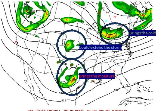
Brings then cold--- has raced out in front and will help deliver cold air from the north. From west of the Blue Ridge to north of 460, I do expect mainly snow.
Brings the moisture--Has slowed just a tad and won't bring the goods until later. I can see Lynchburg not starting until NOON now.
Could extend the storm-- one final piece of energy dives in behind our storm and will let lighter snow linger. Depending on the exact timing, this could add a little more snow as it works with the brings the moisture.
I'm going to wait till mid afternoon for full map update. As of now, I like the "let's add 2 inches to everyone from yesterday, except the far north reaches of my map. They likely won't get as much total precipitation.
For the record, don't fret the NWS not issue a watch for LYH. Reading their office discussion, they are still talking about rain starting before sunrise. The slower trend will hold it off. I'm assuming they didn't fully digest the new runs. Not much, if any data shows it much, if any rain after noon. Sleet, maybe but not rain. A this moment, I see LYH getting 4-6 inches on grass, cars and porches, and 2 inches of slush on pavement, etc
No comments:
Post a Comment