Monday, March 24, 2014

Tune in for the season finale!

I think??

Crazy winter in both Lynchburg and Roanoke that outside of the BIG snow on Feb 12-13, neither place has a snowfall over 2 inches.

So, if by some chance, LYH gets 2.1 inches tomorrow, it will be our second biggest storm of the year. And, there is legit shot at that, albeit not the greatest.

The big storm idea died late last week and while I wanted to update, work was killing me Friday-Saturday. We are left with a clipper system taking a good track for us as it begins to interact with low pressure off the east coast. These two systems will phase, but that won't really impact our part of the storm. There will be a wide area of precipitation with some embedded areas of heavier snow. Now, like Thunderstorms we can choose an area, but can give EXACT details when it comes to this banding.

Most places in VA get a general coating to an inch. The MTS get an additional 1-2 because they are the MTS.

Here is my general idea-- anyone north and east of the black line has the best chance of some heavier burst of snow, but with such strong energy aloft, everywhere has a risk.


We should be just about out of snow chances after this. With that, last year in April 5-6 some snow fell in our region. Looking forward to next year, an "el nino" watch issued recently. Moderate, west based el ninos are historically our best winters. So, if we get that type of  El Nino, which is what we had back in 09-10 I went 25-30 in LYH, 30-35 Roanoke and 40-45 in Blacksburg. I think they were CLOSE to being accurate that winter. Also, the pre summer el nino's are often cooler then normal and wet. Just some ideas for now, we have spring and summer to watch this develop. 

Thursday, March 20, 2014

I will gladly pay you Tuesday...

For a great Friday and Saturday..

There has been a bunch of chatter on social media and other outlets about a possible event next week on Tuesday/Wednesday Time frame.

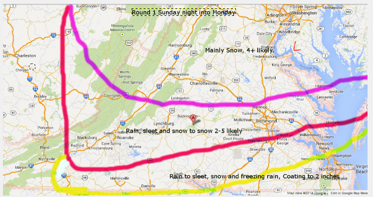
I've been on the verge of posting, but once I start my investment time, it can be very taxing going over data with a fine tooth comb to get the best forecast possible. For a blog that peaks at 600 readers when a storm approaches, that's not a wise use of my time. (But you know I do really enjoy it) Maybe a little late season fatigue because we've had so much to track with a Winter Type advisory or warning EVERY month since November. March has been rough with 2 bad forecasts and the March 6 now cast that was less than accurate. It happens. Sundays event unfolded as expected, with super dry air, we went from 48 and rain to 40 and rain snow mix in an hour. The bulk of the storm was frozen, we just got dryslotted. When it filled, we had changed to sleet. Had that been heavier, it would have been a snow/sleet mix.  So, had we pulled 2-3 inches up front then flipped, my forecast would have been good. But, I digress...

Another spring event? Palm Sunday 13 was a historic event, being the largest spring storm in LYH in 40 years. We could literally match or exceed if the trends continue.

The never ending abundance of arctic air makes another charge at us while ANOTHER short wave spins a low in the gulf. As of now, the low stays decentl off show and this being early spring makes it an ideal track for snow from Western NC up the East coast. Now, we are still 5 days out but the data has been consistent and that matters. Here is the Euro ensembles. (Ensembles are more skilled at this point because they run the data OVER AND OVER, which weeds out bias errors from the runs)

This run on the Euro Ensembles shows a 1007 low amping up to 987 in 24 hours, not quite a bomb but getting deeper fast.

Compliments of Wxrisk.. a good follow on FB. 

Now, the model data shows more liquid along 95, but my guess is if something like that pans out, we'd see the 1inch liquid line back to the BR. With that, March 25th sun--etc, it won't be 10-1 ratio snow stuff.

But, as of now-- if we set the bench mark at the "official" 6.5 inches that fell Palm sunday, I'd say we have  25% chance of breaking that next week. 

What to look for:

1. Track of the low-- the close to the coast the more moisture back towards the  Mts. 
2. Amount of cold-- We still need WELL below normal temps for snow. Our average high now is like 62 or so.  
3. Speed and timing of system. Now, last year snow laid just fine on March 25th, but it was nice and cold aloft. Some snow falling before sunrise Tuesday would be ideal in "insulating" the warmth. 
4. Strength of system. If this phases 2 jets, stronger systems tend to hug the coast and we could eventually have sleet and dry slot issues. 


The good thing is we are not HOPING cold gets here right as the snow shows up like March 3 and Sunday this past week. 

As I said, Wxrisk is an excellent mid range forecaster and will update per model run. He is "woofing" which is what he says when models show a "big dog" AKA big storm

Wxsouth-- has had a phenomenal winter. 

Just remember these guys forecast BROAD areas, so look to the for broad ideas, but fine details are better found from your local NWS and Media outlets. 

Sean Sublette from WSET has a nice blog and has already touched on this system 2x.


Sunday, March 16, 2014

Game time & Storm day!

I think the bust potential is higher than being conveyed to the public. NWS has a warning for 460 corridor from Roanoke to Lynchburg for 4-7 inches. While I have a map from yesterday that says 2-5, and said a few times on FB I lik 3-6, I'm going to hold with my initial map of 2-5 and just added an area of 6+  possible along 81 in north of Lexington.

Here is my map again..


We have NO room for error along 460- NONE. As in, 10 miles south of LYH, rain to sleet mixed with snow is expected and only an inch or two. Having tracked way to many storms, expecting perfection on a model is NOT reasonable. This is a probability map from the WPC about the risk of 4 inches or more. We are on the 50-60% shade, but look how quikcly it drops off to our south. 


So, a 50% or so risk, that up over 80% northern Amherst County and down to 10% risk in Brookneal to 
SML area.  My gut is telling me 1-3 because we just battle too much sleet and rain, but I"ll leave this 2-5 up.

Timing: Rain develops early to mid afternoon and pretty quickly mixes with snow and maybe sleet. Late evening, we may have more issues with sleet mixing in. Temps should fall pretty quickly to the low to mid
30's once rain starts and be mid to upper 20's by this time sunrise tomorrow. 

Once the storm ends, we should have freezing drizzle and flurries from late tonight into the day tomorrow. Round two may not be what my map was, but it's fluid and will change. Chance of freezing drizzle and sleet exists till maybe mid day Tuesday. 

Frequent updates on FB and Twitter. 

7 AM temps are 38 LYH and 40 ROA. 


Saturday, March 15, 2014

Initial Map thoughts

This could end up being a 2 part event.

My confidence for my forecast for round one is about 75%.. It's been charging south, but that has to bottom out soon. Any changes could mean less sleet and rain in Lynhcburg/Roanoke and more snow. Of course, the north trend could appear late and we get more rain and sleet. I will amend these ideas as needed.


I think this map is pretty stable, will need to watch Roanoke to Lynchburg for change from sleet to snow. If everything goes right, we could eek out 6-7 inches along 460. 2-5 is a nice place to start 


Round 2 is not a lock to happen. The remainder of the upper air energy is strong and creates another round of precipitation. We have a ton of cold air below 5k feet, but it's eroding above that. It may be some snow to start, but will transition to sleet and eventually freezing rain. Since most falls overnight, ice CAN build up, especially at night. Confidence is about 40-50% on this round. 

I'll tweet/FB mid day model updates.

St Paddy special?

Well, I'd been tracking this event all week and truly thought it would end up a rain event here. Even commented today that I wasn't "jazzed"--

This AM my thoughts were best snows, a NICE event from the Mason Dixon line up through central PA-- aligned east west so to speak.

What changed?

The entire piece of energy isn't coming out and the confluence, as marked on this map by L up in New Foundland is pushing cold air in faster than I had thought. This am, I could have believed we ended as a little snow and sleet. now, we may be looking a good bit of snow and sleet. The low is shunted due east as cold air filters in. Also, there COULD be a round 2 Monday Afternoon into overnight because all the energy isn't coming out phase 1.


I'll put an early outlook map out tomorrow AM..I think sleet and even freezing rain this late in the year will have to be watched as well as what happens, if anything with round 2.

Thursday, March 6, 2014

Back from the dead-- maybe, or maybe not. :)

** NWS upgraded the Counties that border NC to a Winter Storm Warning with advisories 2 levels up including Amherst and Rockbridge Counties**

After Monday's event-- which was my biggest blown forecast since Jan 2011, I figured this event today would be JUST to our south and outside a little mixed sleet and freezing rain, we'd be all clear by 10am tomorrow.

That's now a MAYBE, and maybe not--

The cold air has trended JUST a bit colder and the storm MAY edge a little north quicker than modeled.

Maybe, and maybe not. :)

This has the potential to see a surprise snow event, maybe or maybe not??

Winter weather advisories are up to the counties just south of LYH and ROA, and the counties to our east including Farmville.
Winter storm warnings for much of NC.

Here is my current call--
ROA to LYH-- Coating to 2 inches of snow and sleet, to freezing rain, ending as rain.

MT. Empire and NRV- 2-6 inches, ending as freezing rain ending as rain.


Will watch this closely, had potential to be a nasty snow event over NRV and MT Empire, and maybe a little more than mapped here for Roanoke, Danville and Lynchburg.


Worst should be over by 10 and a ton should melt after. Back in the 60's on Saturday.


Tuesday, March 4, 2014

If you parents said it snowed more when they were kids....

They were RIGHT!

The 1960's were extremely snow over much of Virginia and in all honestly skewed climate data for decades.

Data from Lynchburg, VA
The 13 year average from 1960-1971 is 28 inches a year, with 2 years of 45 inches, 3 years over 30 inches, 4 years over 20 inches and 3 years in the teens. Lowest winter was 11.5 inches.

There were some incredible stretches of winter..

1960 was looking like the dude of all dud winters with 5-6 inch inches by late January. From Feb 15- March 40+ inches fell.

1961-62 had a snow March with 18 inches from the Famous "Ash Wednesday" storm that destroyed much of coastline from North Carolina to Maine

2 Christmas Snows, Christmas Eve 1966 with 10 inches and Christmas day 1969 with 13 inches.

65-66 had a brutal 2 week stretch in Jan and Feb with 30 inches falling in 2 weeks.

12 inches of snow between 2 storms in November 1968...


I'd have to check data, but if you went 100 years in LYH average is between 17-18 inches or so.

Roanoke had BIGGER winters in 59-60 and 65-66, and a 13 year average of 37 inches.


Friday storm update-- Looks like a non event at this point. MAYBE a little rain and I'll keep and eye but I'm about THIS close to sounding the all clear. Next week has a potential event, but modeled track now goes to our west which means we are in the warm sector.

Side note-- some bad climate data floating around on FB. LYH averages about 17-18 inches a winter. A bit higher when you include these years.