Well Howdy,
I must be the WORST weather blogger with the excessive heat and a few incredible thunderstorms that I've done NO updating on. NONE--
My goal is to improve that. I'm hoping to reformat the entire blog into a REAL website, have daily updates and a bit more features. Time frame on this launch is Oct (tentative)
Today's storm looked a little exciting for a minute, but once it approached there wasn't much where I was on Timberlake Road near Lynchburg. Other places had some hail--etc but none where I was.
So, my goal is to get more consistent updates and move away from the blog format. Winter weather is my greatest passion, but I do get pumped up over Severe and Hurricanes. I'll start to add more information on that as well to provide a more comprehensive service. With that, I'd suggest everyone follow Sean Sublette from WSET and Jamie Singleton when a severe event is on tap. For my money, they are two best local FB/Twitter guys. WxRisk.com is worth following on FB-- he does more medium and long range stuff and is "full of personality" as well.
However, a little pre thought about winter. It seems clear that we are heading into an El Nino. If you recall my winter outlook in Winter 09/10 about how a moderate,west based El Nino is best for our region. Breaking that down a little, anything above a +1.2 in regions 3/4 of the Pacific is GREAT for us. The model data is not exact but some guess have it CLOSE to 1.2 but not quite there. (East based El Nino's are another beast as well) Anyways, if you want a decent winter-- just on stats alone that 1.2 places us in the best statistical place for an exciting winter.
Friday, July 27, 2012
Monday, February 20, 2012
Post storm wrap up
Wow, what an event!
It was a forecasting challenge but in the end just was a fun storm to be a part of. It's clear the highlight of the storm was between 5 and 6 PM where .22 liquid fell at the airport in Lynchburg. That was likely a tad above 10-1 ratios, so maybe as much as 2.5 inches fell that hour. I was out with my middle son making a snowman and sledding and it seemed every time we didn't move the sled, 5 minutes later it had a quarter inch on it.
In Lynchburg proper, we really lasted in the meat of the band longer than other locations in our area with another .10 an hour between 7 and 9 pm. Here's a view of the LYH obs--

My forecast overall- I'll give it a B. Had I held to my original map, I'd say that was an A. Using models as guidance can be very tricky. As the event was approaching it was clear there would be a 2 part event-- event one was the first push of moisture and it seemed it would have incredible "frontogensis" -- two airmasses collide into each other. In this case, it was the moisture from the sub tropical jet hitting the cold air sliding in from the north. This part of the event was decent- general 1-4 inches region wide but that wasn't the main show. The model data was much stronger on this in the 2 days before the event until that last second jog south in the models.
The second part was caused by the mid level circulations-- 850 and 700 MB low. These are harder to forecast as their tracks are not as exact and where the best banding set up would be somewhat difficult to pinpoint. The late night model runs Saturday night pushed them down closer to the VA/NC border. My concern was we'd about get next to nothing (especially far east) from round one and round two would be more intense to our south.
Round one went as expected and round two slide north vs the model data. About 6.5 inches of the snow in Lynchburg was from that second round associated with the mid level low.
Here are some regional totals-- many are incomplete. If you check the time stamp, anything that is before midnight or so isn't the entire storm.
I expect the LYH total to be 8 or 8.1 (current report is 7.7 but it's incomplete) Roanoke is 5.5, Blacksburg is 6.8 and Danville is 3.
Enjoy the snow today-- 45 for a high today, 55 tomorrow and 60s by Thursday! It will all be melted by late tomorrow except the plow piles.
Sunday, February 19, 2012
Maybe a silver lining--
Tough storm. We went from being on the southern fringe of a northern VA event, to the meat of the heaviest band, to the northern fringe in 48 hours. My concern before of banding sliding to our N has not MAYBE turned into hope as banding is never modeled well 48 hours out and it become a short term, meso issue. As the upper air energy approaches that banding is become more defined a should hit PARTS of our area. That's going to be the show here--
Here is a link to the HRR, a short term new model. This is a " modeled" radar loop. If this happen, this will be a nice little event. Do note the first band brushes LYH to the north and the second COULD scoot just to our SE. Still, parts of our area would do well and there is a little more coming late.
I like my last call-- but this could add a LITTLE bonus snow.
http://rapidrefresh.noaa.gov/hrrrconus/jsloop.cgi?dsKeys=hrrr:&runTime=2012021912&plotName=cref_sfc&fcstInc=60&numFcsts=16&model=hrrr&ptitle=HRRR%20Model%20Fields%20-%20Experimental&maxFcstLen=15&fcstStrLen=-1&resizePlot=1&domain=full&wjet=1
Wholesale changes.
I've never been a fan of the "weatherman can get it wrong" half time time and still have a job. Can an accountant balance a ledger with estimates? If the estimate was $200 and the actual was $1200-- they will be way off. Weather forecasting is the same way- we use the data we have and hope the sample is accurate. This storm had so many moving parts it has been hard to gauge each one. And, as a result we've got to make some changes.
I should have mentioned there was a shot this thing ended up a little more suppressed. I really didn't see it was SUPER viable option, but it would have been prudent. My thinking was 50 mile wiggle room either way keeps us in close to 4 inches of snow. The wiggle was more like 75-100 miles.
Model data has trended south and radar looks CLOSE to that portrayal. The mechanism to deliver cold air (jet stream area) and has shunted it a little faster to our south. As a result:
1. We get less moisture.
2. We needed the heavier snow to overcome the warm ground. I had no issue saying the warm ground doesn't matter as long as the snow is falling a decent clip. We should get some type of a decent burst later today, but before we may have lighter sleet/snow and rain because it's light and we can capitalize on the lower dew points to drop the temps. So, we will have more rain than I first thought or snow that just won't accumulate this afternoon.
Adjusted thinking. May do a map by mid day, not that it helps anyone at that point.
NRV-- 4-6 inches.
Roanoke Valley 3-5
LYH 2-4 with 2 up in Amherst and 4 closer to Altavista.
Southside- 4-8.
In general being Northeast is bad and being South and Southwest is good.
I can see a scenario where the banding still sets up north. Banding is NEVER modeled well-- despite all the changes in the models. As a result, Lynchburg has close to nothing at 5pm, everyone thinks its a bust and the storm strengthens and a band dumps 5 inches in 4 hours. This will have to be monitored. I don't want to sound like Princess Leah, but this could be our ONLY HOPE to get 5 inches in LYH.
We are in nowcast mode-- Model data helps, but radar, water vapor matter more. Feel free to friend me on facebook or subscribe Keith David Huffman, twitter @ VirginiaWx for current updates.
A short term model called the HRR keeps us dry all day, but creates a decent band LATER AFTERNOON-- this would be impressive for a few hours.

A short term model called the HRR keeps us dry all day, but creates a decent band LATER AFTERNOON-- this would be impressive for a few hours.
Saturday, February 18, 2012
Things seem on track for a nice winter event. I specifically wore short sleeves to my my sons basketball game to soak it all in. Overall, model data has held fast. I'd say that we are on tap for a liquid event of .6 to .9 along the 460 corridor from Blacksburg right into Richmond. Precipitation will be MAINLY snow, but the fist 1-2 hours could have some sleet and rain mixed in. Also, I expect a late afternoon early evening lull that could have some sleet and or freezing drizzle falling. Outside of that, mainly snow. Even Danville should do a little better snow wise.
I expect a strong push of mix changing to snow, and a lull later, followed by colder temps and a second push of heavy snow due to the approaching vort going to our south. That could produce some heavy snow rates Sunday evening. Timing wise, the slow down has been about perfect for our region if you wanted a good snow.
What could go wrong?
I have some concerns about the total precipt that the one vort circled earlier that could crush our wave enough to pull us down to a half inch or so of liquid. Also, while I'm not really worried about temps, that's always got to be a thought if we mix more then I anticipate.
What about the warm ground?
Over rated, over rated, and over rated. If it was marginal cold aloft falling to temps at the surface of 33, I'd have concerns. Yeah, it's not going to lay on the road fast-- but grass, cars, benches decks will have accumulations fast. When the "lull" I talked about, you may settle and lose some depth-- let's say you have three inches at the end of round 1, it may condense to 2.5 inches and you get another 4 on the back side. You had 7 inches fall still. With that, temps are very cold-- just above the surface we will have temps at .-5 c at times. It's not going to be a "wet" snow other then the surface temps won't be bitter. I can even see the evening action being almost powder like. Citing examples-- 09, 05, 01 all had events where the temps were well into the 50's the day before. Feb 22 01 I played basketball in shorts and we had a 2-4 inch storm the next day. The bulk came in 2-3 hours in the morning and when it slowed, that snow did NOT melt.
Start times- Far SW around Sunrise-- 10-11 am in LYH. End time? 10 PM far SW, 2 AM East of LYH.
Some mixing and just a tad warmer overall keeps Martinsville to Danville and over to South Boston a little low. Now, when that second piece of energy dives in, they may catch up well.
As for my map, the bulk of my focus is the Blacksburg Warning area. If you're outside that region, shoot me a message and I can look up more specifics in your region. I also didn't do much for NC-- there is some uncertainly everywhere, include those from 40 up to the NC/VA state line. Second wave could cash them in with a decent event.
My thinking as of now. May have to massage a little here or there, but I like how this looks.
 |
| Final call |
Water, water, every where, Nor any drop to drink.
Fun, interesting storm to follow. Model data has now literally done a complete reversal on some levels and some data has suggested we miss the best snows to our SW and even S rather than N and NW.
What's going on?
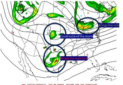
The overall storm has slowed. We have three moving pieces as shown below. This are the upper air energy, "swirl's" they call them on storms associated with our storm. They are about 17k feet about the ground.
What's going on?
The overall storm has slowed. We have three moving pieces as shown below. This are the upper air energy, "swirl's" they call them on storms associated with our storm. They are about 17k feet about the ground.

Brings then cold--- has raced out in front and will help deliver cold air from the north. From west of the Blue Ridge to north of 460, I do expect mainly snow.
Brings the moisture--Has slowed just a tad and won't bring the goods until later. I can see Lynchburg not starting until NOON now.
Could extend the storm-- one final piece of energy dives in behind our storm and will let lighter snow linger. Depending on the exact timing, this could add a little more snow as it works with the brings the moisture.
I'm going to wait till mid afternoon for full map update. As of now, I like the "let's add 2 inches to everyone from yesterday, except the far north reaches of my map. They likely won't get as much total precipitation.
For the record, don't fret the NWS not issue a watch for LYH. Reading their office discussion, they are still talking about rain starting before sunrise. The slower trend will hold it off. I'm assuming they didn't fully digest the new runs. Not much, if any data shows it much, if any rain after noon. Sleet, maybe but not rain. A this moment, I see LYH getting 4-6 inches on grass, cars and porches, and 2 inches of slush on pavement, etc
Friday, February 17, 2012
If you ain't first, you're last!!
12z Model data is confirming that a colder, snowier solution is becoming more likley. With that, I'm opting to NOT attempt to be the first go bigger, but try to be give an honest presentation of where things sit.
With that, my statement of adding two inches to my first guess seems more and more likely. However, in terms of "wiggle room". I can see 50 miles of wiggle room on the models. 50 mile wiggle north moves LYH from 6-7 inches on the GFS to 2-3 inches. 50 miles wiggle south on the NAM moves LYH into well over a foot (as modeled)
We've got a ways to go here-- I'd expect winter storm watches by either later this afternoon or early Satuday. (Excluding southside)
Full update during late evening model runs.
Subscribe to:
Posts (Atom)