All data has the northern stream data much too strong for this event and as a result the threat for any significant is basically gone. A coating of snow is still possible--- but not likely.
We do get nice and warm next week!
Shortest blog ever??
Monday, February 7, 2011
Sunday, February 6, 2011
The Thursday storm has flatlined-- attempts to revive in process.
All noon data continues to drift away from the event-- and some data now says "what event". The northern energy is much more dominant and kills our southern energy as it heads east. The GFS is the "best" for snow model giving an inch or so while the GGEM/ECMWF basically have nothing.
Is this legit??
Very well could be. When I painted my possible solutions, one concern was keeping that southern vort strong and consolidated. The northern branch just beats it down and shreds it. We've had northern branch issues all year and there is no reason to consider they won't continue. This is very common in a La Nina winter.
If the evening data doesn't start to indicate a revival, I'm ready to pull the plug.
A huge step backwards---
 |
| Vort issues abound. |
All three models showed a coating to 2 inch snow storm.
Is this the final outcome??
No-- not at all. It is very common for model data to be all over the place 5 days out. Especially with regards to the northern piece of energy which is currently in a very poor area to gather data about it.
When will you have a better view on the northern vort issue?
Educated guess says hopefully by noon tomorrow, by perhaps as late as the midnight runs on Monday night. For a good storm we want that southern vort strong, the northern vort to be minor or non existent *further north* and we'd be in business for a good snowfall.
Valentines week is going to be nice and warm-- several days up in the 50's and dare I say 60's.
2 quick notes
1. The blog was adjusted to better mobile viewing. It worked on my phone, but a tried another's phone and got the FULL blog. If you have a second check on your smart phone and drop me a message via comments here or on facebook.
2. I've purchased the domain name www.VirginiaWX.com with my google adsense money and have made that click right into the blog. My goal is to build that into an actual site and have it running by next winter. I will keep up on the blog over the summer, but with maybe not quite as much vigor. I'm sure you would all be thrilled to hear reports of another day of 94 degree heat.
Saturday, February 5, 2011
Kick a buck---
The Noon model data has just completed and as the bidding passes my spot, I'm throwing in another buck so the pot is a little richer now.
Quick run down by model
Recall- We need the Monday storm to BLOW UP forcing the cold air deep to our south AND the upper air energy (Vortmax) to not shear out or just not be consolidated.
1. GFS (American Model)-- Blows up the clipper and pushes in cold air. However, it struggles to hold the upper air energy and we get a minor storm. As shown, its a 1-3 inch snowfall Thursday.
2. GGEM (Canadian) Blows up the clipper, holds the upper air energy a little better and its maybe a 2-4 inch snowfall.
3. ECMWF (European) Blows up the clipper as needed and keeps the vortmax VERY strong. as a result, its a BLOCKBUSTER snowstorm. Literally, 12-15 inches region wide-- maybe more because the air is cold and the ratio of snow to liquid could be more like 15-1.
What now??
Waiting game is on. Almost all data shows the clipper blows up. At this point, its just making sure its at an ideal location and drives the cold air well to our south. Second, the data is all over the place with the strength of the vortmax. Despite some data suggesting it could be a bigger storm to our south and east, my greatest fear is always it trending north. Despite the models being very cold, a subtle 100 miles north track in the vortmax leaves us open for a mix to ice or even rain. With this being a fast moving volatile pattern, anything is possible. Even compared to the midnight data, the ECMWF was several degrees warmer with the antecedent cold shot. Comparing to the great MW blizzard from this past week-- St. Louis was at one point was forecasted to get a dumping of ice with a foot of snow on top. The low drifted MUCH further west then modeled an ended up with less then an inch of total precipitation when they were modeled to get over 2 inches.
When will we know??
Like most events, nothing will be set in stone until a day out or less. Both the GFS and ECMWF computer models have biases that are at play here. The GFS tends to crush storms at this range while the ECMWF has consistently OVER done coastal lows at this point in the game. The GFS issue holds water because of that HUGE low that develops. The EC isn't really a over blowing a coastal low, its just an amped up vortmax.
My gut call as of now-- IF we see the big storm idea come to fruition, we will have to battle the dreaded rain/snow/ice line across much of region, including Lynchburg and Roanoke.
Let's give him something to blog about---How about snow??
I had not quite yet put away my shovel and sled, but was accepting the fact that winter's end was coming near. While I do like snow and cold, I also enjoy lower heating bills. I sent in my payment this week--so please click away on those GOOGLE ads to offset my heating costs. :)
My expectations of the this week was the storm tomorrow was MOSTLY rain, a second storm slides to our north and cold air builds in. As the cold exits, a MAJOR low develops and goes WELL to our west. Not a Chicago blizzard like this past Tuesday, but an Ohio snowfall into the upstate of NY.
The models data has shifted---it takes the early week storm a clipper and BLOWS it up to a sub 950 storm. Some data makes the central lowest pressure at 944 MB which is a CAT 4 Hurricane strength. This pushes cold air well to our south and sets the stage for a possible snowfall.
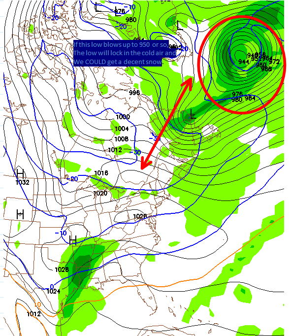 |
| Rare to see a 944 low up there. |
I still expect a break or even end to the cold shortly after Valentines Day--BUT, this is a legit "Threat" as of now next Thursday.
1. We need the clipper to blow up as modeled. This is rare, but did happen something like this right before the Feb 5-6 snow event here. (6-10 region wide here, 2-3 feet DC to Philly)
2. Once we know the low blows up-- which will be established by Sunday allowing the cold air to lock into place, we need the energy aloft to take a favorable track and be strong enough to make a decent storm.
If BOTH of these things happen, we could get our best snowfall of the winter.
Friday, February 4, 2011
Couple of storms to get through-- and then winter takes a break,
There is a freezing rain advisory tonight-- but that is for the higher elevation. I expect MAYBE a little sleet where most folks live, and really this is just a rain event.
We've got one last cold blast to get through with storm to go with it. While this is an amped up pattern, we lack the high lattitude blocking to keep the cold air locked in place. This will be another major blizzard somewhere and I imagine it will be parts of the Appalachia , maybe into the Ohio Valley, and inland New England. If this storm wraps up as it could, we will get 2-3 bitter cold days.
The good news-- after this, the pattern does seem to drastically shift and the mean trough will be on the west coast and ridging along the east coast. So, many signs point towards a much more mild pattern starting mid month. We will keep a close watch on this storm for next week, but I see very little to support this being a major event for us.
Tuesday, February 1, 2011
Winter to take break...??
My ice event did not come to fruition, but that was a good thing. That small amount of ice can take a few people off guard--but better to err on the safe side.
Closing thoughts-- I wish I could dig up the chart, but someone made a list of the major reporting stations in VA for winter snowfall totals and Lynchburg is DEAD LAST with a little over 8 inches. Norfolk is still in the lead with the 14 inch storm on Boxing Day event and a seasonal total of 18 inches.
If you are tired of the cold and snow-- you may be happy with this paragraph. In an La Nina winter- the mean troff (Storm track) usually shifts westward as the winter progressive. We've slowly watched that unfold-- as we were bitterly cold in December, coder then normal in January and looking at Feb-- even if we get the " Sudden Stratospheric Warming" event I talked about before, if the mean troff is to our west and we have no blocking to our east, our cold shots will be very short lived. Some data is slowly pointing in that direction. If this happens, despite the colder then normal January, my winter forecast won't look too bad. (Troff was well off shore in December, slightly west in January and well west in February)
February of 89 was a La Nina winter and had the mean troff sitting to our west. We did have a couple of threats for snow later in that month and a couple inches did accumulate but the big snows ended up in the Hampton Roads area ( Two big storms a few days apart with 70 degree weather in between them--February 18th and 24th, 2 and three inches fell respectively here in Lynchburg while 10+ across the Hampton Roads area from each event) This matches will with both a La Nina pattern with a west troff-- as cold air moves through the mean troff is briefly off shore and the best storms go to our east.
We can use any rain-- so hopefully we get the half inch possible tonight. Another storm approaches Saturday and another decent rain is possible. There isn't much fun blogging about rain but we certainly need it and for those of us who enjoy local produce each summer, we must have it.
Subscribe to:
Posts (Atom)