My expectations of the this week was the storm tomorrow was MOSTLY rain, a second storm slides to our north and cold air builds in. As the cold exits, a MAJOR low develops and goes WELL to our west. Not a Chicago blizzard like this past Tuesday, but an Ohio snowfall into the upstate of NY.
The models data has shifted---it takes the early week storm a clipper and BLOWS it up to a sub 950 storm. Some data makes the central lowest pressure at 944 MB which is a CAT 4 Hurricane strength. This pushes cold air well to our south and sets the stage for a possible snowfall.
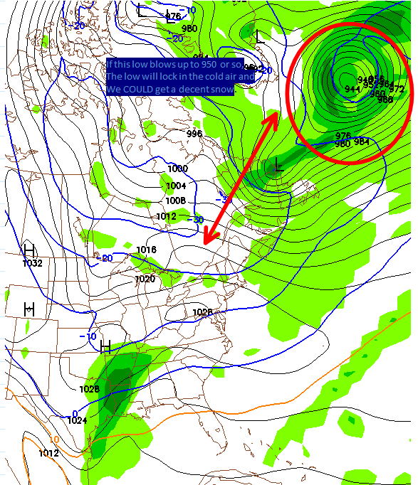 |
| Rare to see a 944 low up there. |
I still expect a break or even end to the cold shortly after Valentines Day--BUT, this is a legit "Threat" as of now next Thursday.
1. We need the clipper to blow up as modeled. This is rare, but did happen something like this right before the Feb 5-6 snow event here. (6-10 region wide here, 2-3 feet DC to Philly)
2. Once we know the low blows up-- which will be established by Sunday allowing the cold air to lock into place, we need the energy aloft to take a favorable track and be strong enough to make a decent storm.
If BOTH of these things happen, we could get our best snowfall of the winter.
Let me add, that as modeled on the Euro, temps Friday AM are BITTER cold from 0 to 10 below most of VA. Verbatim, Lynchburg is 10 below! We do have plenty of cold air behind this storm -- so its if we get snowpack, clear skies-- VERY cold temps are possible.
ReplyDelete