 |
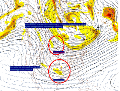
| Vort issues abound. |
All three models showed a coating to 2 inch snow storm.
Is this the final outcome??
No-- not at all. It is very common for model data to be all over the place 5 days out. Especially with regards to the northern piece of energy which is currently in a very poor area to gather data about it.
When will you have a better view on the northern vort issue?
Educated guess says hopefully by noon tomorrow, by perhaps as late as the midnight runs on Monday night. For a good storm we want that southern vort strong, the northern vort to be minor or non existent *further north* and we'd be in business for a good snowfall.
Valentines week is going to be nice and warm-- several days up in the 50's and dare I say 60's.
2 quick notes
1. The blog was adjusted to better mobile viewing. It worked on my phone, but a tried another's phone and got the FULL blog. If you have a second check on your smart phone and drop me a message via comments here or on facebook.
2. I've purchased the domain name www.VirginiaWX.com with my google adsense money and have made that click right into the blog. My goal is to build that into an actual site and have it running by next winter. I will keep up on the blog over the summer, but with maybe not quite as much vigor. I'm sure you would all be thrilled to hear reports of another day of 94 degree heat.
good post DT
ReplyDelete