Sunday, March 16, 2014

Game time & Storm day!

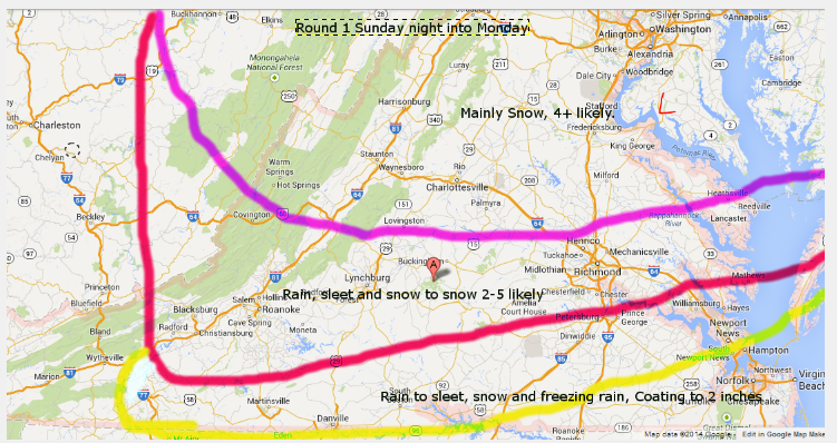
I think the bust potential is higher than being conveyed to the public. NWS has a warning for 460 corridor from Roanoke to Lynchburg for 4-7 inches. While I have a map from yesterday that says 2-5, and said a few times on FB I lik 3-6, I'm going to hold with my initial map of 2-5 and just added an area of 6+  possible along 81 in north of Lexington.

Here is my map again..


We have NO room for error along 460- NONE. As in, 10 miles south of LYH, rain to sleet mixed with snow is expected and only an inch or two. Having tracked way to many storms, expecting perfection on a model is NOT reasonable. This is a probability map from the WPC about the risk of 4 inches or more. We are on the 50-60% shade, but look how quikcly it drops off to our south. 


So, a 50% or so risk, that up over 80% northern Amherst County and down to 10% risk in Brookneal to 
SML area.  My gut is telling me 1-3 because we just battle too much sleet and rain, but I"ll leave this 2-5 up.

Timing: Rain develops early to mid afternoon and pretty quickly mixes with snow and maybe sleet. Late evening, we may have more issues with sleet mixing in. Temps should fall pretty quickly to the low to mid
30's once rain starts and be mid to upper 20's by this time sunrise tomorrow. 

Once the storm ends, we should have freezing drizzle and flurries from late tonight into the day tomorrow. Round two may not be what my map was, but it's fluid and will change. Chance of freezing drizzle and sleet exists till maybe mid day Tuesday. 

Frequent updates on FB and Twitter. 

7 AM temps are 38 LYH and 40 ROA. 


Saturday, March 15, 2014

Initial Map thoughts

This could end up being a 2 part event.

My confidence for my forecast for round one is about 75%.. It's been charging south, but that has to bottom out soon. Any changes could mean less sleet and rain in Lynhcburg/Roanoke and more snow. Of course, the north trend could appear late and we get more rain and sleet. I will amend these ideas as needed.


I think this map is pretty stable, will need to watch Roanoke to Lynchburg for change from sleet to snow. If everything goes right, we could eek out 6-7 inches along 460. 2-5 is a nice place to start 


Round 2 is not a lock to happen. The remainder of the upper air energy is strong and creates another round of precipitation. We have a ton of cold air below 5k feet, but it's eroding above that. It may be some snow to start, but will transition to sleet and eventually freezing rain. Since most falls overnight, ice CAN build up, especially at night. Confidence is about 40-50% on this round. 

I'll tweet/FB mid day model updates.

St Paddy special?

Well, I'd been tracking this event all week and truly thought it would end up a rain event here. Even commented today that I wasn't "jazzed"--

This AM my thoughts were best snows, a NICE event from the Mason Dixon line up through central PA-- aligned east west so to speak.

What changed?

The entire piece of energy isn't coming out and the confluence, as marked on this map by L up in New Foundland is pushing cold air in faster than I had thought. This am, I could have believed we ended as a little snow and sleet. now, we may be looking a good bit of snow and sleet. The low is shunted due east as cold air filters in. Also, there COULD be a round 2 Monday Afternoon into overnight because all the energy isn't coming out phase 1.


I'll put an early outlook map out tomorrow AM..I think sleet and even freezing rain this late in the year will have to be watched as well as what happens, if anything with round 2.

Thursday, March 6, 2014

Back from the dead-- maybe, or maybe not. :)

** NWS upgraded the Counties that border NC to a Winter Storm Warning with advisories 2 levels up including Amherst and Rockbridge Counties**

After Monday's event-- which was my biggest blown forecast since Jan 2011, I figured this event today would be JUST to our south and outside a little mixed sleet and freezing rain, we'd be all clear by 10am tomorrow.

That's now a MAYBE, and maybe not--

The cold air has trended JUST a bit colder and the storm MAY edge a little north quicker than modeled.

Maybe, and maybe not. :)

This has the potential to see a surprise snow event, maybe or maybe not??

Winter weather advisories are up to the counties just south of LYH and ROA, and the counties to our east including Farmville.
Winter storm warnings for much of NC.

Here is my current call--
ROA to LYH-- Coating to 2 inches of snow and sleet, to freezing rain, ending as rain.

MT. Empire and NRV- 2-6 inches, ending as freezing rain ending as rain.


Will watch this closely, had potential to be a nasty snow event over NRV and MT Empire, and maybe a little more than mapped here for Roanoke, Danville and Lynchburg.


Worst should be over by 10 and a ton should melt after. Back in the 60's on Saturday.


Tuesday, March 4, 2014

If you parents said it snowed more when they were kids....

They were RIGHT!

The 1960's were extremely snow over much of Virginia and in all honestly skewed climate data for decades.

Data from Lynchburg, VA
The 13 year average from 1960-1971 is 28 inches a year, with 2 years of 45 inches, 3 years over 30 inches, 4 years over 20 inches and 3 years in the teens. Lowest winter was 11.5 inches.

There were some incredible stretches of winter..

1960 was looking like the dude of all dud winters with 5-6 inch inches by late January. From Feb 15- March 40+ inches fell.

1961-62 had a snow March with 18 inches from the Famous "Ash Wednesday" storm that destroyed much of coastline from North Carolina to Maine

2 Christmas Snows, Christmas Eve 1966 with 10 inches and Christmas day 1969 with 13 inches.

65-66 had a brutal 2 week stretch in Jan and Feb with 30 inches falling in 2 weeks.

12 inches of snow between 2 storms in November 1968...


I'd have to check data, but if you went 100 years in LYH average is between 17-18 inches or so.

Roanoke had BIGGER winters in 59-60 and 65-66, and a 13 year average of 37 inches.


Friday storm update-- Looks like a non event at this point. MAYBE a little rain and I'll keep and eye but I'm about THIS close to sounding the all clear. Next week has a potential event, but modeled track now goes to our west which means we are in the warm sector.

Side note-- some bad climate data floating around on FB. LYH averages about 17-18 inches a winter. A bit higher when you include these years.

Monday, March 3, 2014

Stepping backwards

Models and humans-- both fallible. 

Radar has gone to the crapper and this wont't be a 4-8. Outside shot at 3-4 to verify low, but more like 2-4 region wide. 

Add 1-3 on what you have-- which will be 1-4 across the region. Dry air killing the storm with heavier bands racing away. Other snow will be more powdery. 

My roads were covered and that's melted since it's march. However, temps fall into teens still some flash freeze concerns. 


Best efforts don't get snow on the ground. I read the system correct as modeled, just didn't bring it home. :)

Sunday, March 2, 2014

Tough times, tough calls

Fun storm to track and just epic model battles with models trading places over and over again.

1. Well established south trend was CLEAR yesterday. Often, when things trend north we assume the trends STOPS and it simply doesn't.  I've seen storms end up 100 miles north of modeled AS the storm unfolds.

2. South trend with the storm does NOT always equal colder air being locked in places. So, while we've trended wetter, doesn't mean more snow-- could be more sleet.

3. Speed. Heaviest stuff is out of here by 1pm, if not sooner. Could be 11. So, again-- we need the flip early. Afternoon snow will be light and fluffy stuff with temps around 15-20

4. Even if we flip, clould physics may not make it "fluffly snow" AKA snow grains and stuff that doesn't build up well.


I had floated a MAP on FB-- didn't make it "official"-- Made a little revision of upping DC to 8-14 and moving LYH to 4-8.

Sleet will be an issue. Marked in Yellow on the map.. IF we can get rid of sleet sooner,could see 10 inches in LYH. I'd say that's a 25% shot we see 10 inches. I'd say 6 inches in LYH seems like a safe call.

Temps in TEENS by mid morning VERY possible.

Sleet fest for 460-- :)