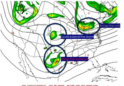
With our "minor" drought conditions here (there was impact from the heat on local crops-- not specific to drought) we will get a nice break of cooler and wetter weather. We've had a ton of showers and thunderstorms but nothing "region" wide. I can think of 2-3 times this summer where the models showed a decent rain and we got NOTHING or very little. I do like how this looks at this point. As a reference, here is the HPC's rainfall total over the next 5 days.
These events tend to be more showery and the gradient won't look anything like that. However, I like how this looks and think we do see a region wide .75 to 2 inch rainfall over the next 5 days. A little more could be in the pipeline AFTER that.
For those who enjoy tropical events-- Earnesto is fighting it's way through some tougher conditions and should achieve hurricane status later this weekend/early next week. The question is does it run into the Yucatan and just fade out or graze it, end up in the gulf as a more strong threat to the Gulf states region. My take now is I'm hedging more towards the graze into the gulf, but we've got plenty of time. If you're a map person, the NHC has some good easy to read info on their website.
http://www.nhc.noaa.gov/refresh/graphics_at5+shtml/203848.shtml?tswind120#contents
There was a nice flare up of convection near the Bahamas recently and that has slight potential to form but what I'm really interested is the flair up off the Africa coast-- labeled as LIKELY to become Tropical System in the next 48 hours. We should have Florence by early next week.


