Sunday, January 24, 2021

Wednesday Night- Thursday Snow storm.

 Well, we made it to Sunday and we still have a snow threat middle part of the week. With that, the threat changed in how it is set up. 

The first view on the models had well into cold and very dry air and a storm even cutting west of our region, snow would break out and likely maintain as snow as the low jumped towards the coast. 

As we've gotten closer, the storm seems to be about 12 hours faster, starting overnight Wednesday and the cold air is not quite as strong changing the storm to a dynamically driven event. (And that's if the event takes place) This means we have to rely on the a strong upper air low to interact with the surface low and cool the atmosphere by both pulling in the cold air that is slowing sinking towards our region AND the strong lift (rising air cools, sinking air warms) from the deepening low.  This is because we don't have cold air in place, but arriving and being created as the storm unfolds. 


We have 2 basic storm evolutions displayed:

1. Precipitation from the west comes in over head as the upper air and surface low interact. Storm gets close enough and we got heavy rain to heave snow. Data showed 4 to 8 inch snow totals in this event with a sharp south cut off. Remember, 4 days out thinks like to drift north so this could happen but we get next to nothing. 

Another evolution problem is that some models showed the precipitation moving in from the west and as the transition happens the precipitation collapses quickly towards the low. Hence, we get the higher end solution but it infers risks that little to no snow could fall in that region. (That zone was east of the Blue Ridge)

Variations of this are show on the GFS and to an extent the Canadian Model. 
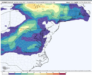

Current American Model risk of 3 inches.
European model risk of 3 inches in percentages. 

American Model risk of 3 inches. 


2. Very little precipitation over head initially but the upper air low initiates a round of snow more along the lines of 1-3 inches. These tend to be more challenging to forecast because upper air snow "form during the event"-- so some people get it and some don't. The models showed a NW to SE band of snow that coved much of our region. 


Variations of this have been shown on the Euro and UK met model. 


Snow Potential. 

30% chance your specific location gets no measurable snow. (Trace amounts fall here)

40% chance your location sees a coating to 2 inches. 

20% chance your location sees 2-4 inches

10% chance your location sees over 4 inches. 


Here are my current views for risks

Very broad brushed at this time, but this is by far our best shot region wide for some snow. Each region has reasons why they could miss. Southside could be too far south, NRV and I81 region could be too far west. Lynchburg could literally be to east, too west, to north and too south. (It feels that way after almost 2 years with no measurable snow) 


Sunday, January 17, 2021

To Ridge or not to Ridge

 Despite the mini blizzard in parts of the region yesterday,  we have no specific threats on the horizon for winter weather. We've had some great blocking in the North and East of us (Good for snow) but inconsistent blocking to our West. This lack of blocking, combined with the very Warm December has killed any change of snow. If we had any level of pre existing cold, we'd of had a few events at this point. Instead, Lynchburg and Danville have no snow while Roanoke and Blacksburg are inching forward with small events. 

A key source of our cold air comes from the EPO region (Eastern Pacific Oscillation) and where that Ridge sits controls if Canada gets cold. Remember, Canada was very warm after December and the cold has been blocked on the other side of the  world. 

There could be some light rain or maybe even light snow Friday across the region but early next week there is a threat of something (January 25 to 27) Some models are running the low pressure across the Great Lakes (maybe some ice to Rain) Some are taking it right at us which is snow to ice to rain some places and a few, which in build that ridge across Alaska force it to our south and we see some snow. I have no faith in this ridge because it's been "forecasted" to build all month and simply has not, but eventually it should.  If the ridge isn't there, the cold air that comes in simply isn't that cold and the storm will move to our north. 

In a La Nina winter, quite often the best threats are in February and actually into March but early month I was somewhat optimistic we'd have an event or two by now. At this point, I am just hoping we can get an event or two this winter. La Nina winters are use less than average snow save a winters aside. 

Wednesday, January 6, 2021

Will we Cash Out or Crap Out?

 In the digital world of weather, the 0Z (Midnight run) of the Euro had 3 digital storms starting with Friday that brought us all snow each storm. The end total was 10 to 18 inches total from the three storms region wide. 


Will We Crash in or Crap out? The noon run of the same model lost all 3 storms, for those wondering. 

Specific to Friday's event. Those who forecast this right will have a blend of both luck, skill and climo knowledge. 


Summary- A low pressure and associate upper air low will approach the area. Some unusual factors make it a challenge to see how far north this storm will make it. Further, this may be a rare case where the upper air low impacts our area. Last big time I think this happened, Roanoke and Blackburg had 10 inches of snow in 3 hours during February of 2014 (after 10 had already fallen)


I am against showing the digital snow maps but I will show a few to show the challenge. Making it worse, the models often shift back and forth on what the outcome will be. 

Mid afternoon run of 12k NAM, Big snows southside, misses most of Roanoke to Lynchburg. 


Noon run of American Model that show now snow within 60 miles of Lynchburg. 

\


3k NAM run mid afternoon, big snows into LYH, still mostly a non event in Roanoke. 

We are 48 hours from the event where clarity is not event close and many outcomes are possible. With that, it's not called forecasting for nothing. 


My initial thoughts for this first event-

Snow breaks out towards Morning southside and over spreads the entire region. This first push first guess is 2-4 inches from about the NRV South East towards South Boston. Further SW VA may do better here ( 3 to 6) Along 460 From Roanoke to Lynchburg this round will bring 1-3 inches. 


From this point, the forecast is tricky. The upper air support should then create a second round of snow. This is more tricky because it should be convective (think thunderstorm like, hit and miss) You get in these bands, you could get another 3-5, if you just get brushed another inch or two. Some places may be done after the initial push of snow. Very challenging. 


So, my current "First Guess"

  NRV down to Southside- 2-4 inches then we wait on the bonus snow.  If you get in the good bonus snow another 3-5 is possible. everyone won't get this. 

Roanoke to Lynchburg 1-3 initial push. 3-5 bonus snow possible too. Same disclaimer for not everyone will get it.

Everyone won't get it because often these bands set up and just don't really move. Then then weaken in that spot and form elsewhere. 


This is not a final call and this will change before the event.  Some timing issues where some models really hold off accumulating snows until late afternoon and other have snow on the ground in Lynchburg by 7 am. 


Other events worth watching early next week and then NEXT weekend.  Expect updates via Twitter and FB. 


Sunday, January 3, 2021

The answer may be Friday/ Saturday to the question I get asked the most.

There is an event I've been tracking a few days that looks to take place in the Friday to Saturday time frame. We have the "Blocking" pattern I discussed but not a ton of cold air. A few models have hinted at the block forcing a system to our south with just enough cold air for snow in parts of the region. In the past couple runs of the models, there seems to be growing concensus in the models that the storm will both travel to our south and have "just enough cold air" in place. 

 Points to ponder- 
1. Things change as we get close. This is an outlook 5 days away. 
 2. Timing is not locked in as some models show early Friday start and others early Saturday. 
 3. Models have looked colder, not super cold as we get close. We obviously need the cold. Some places east and south may not have enough cold air or depending on timing, places may start as snow and end as rain. 
 4. This event that may stay to our south with the upper air puts is in "cold conveyer belt snows" where the upper air feature provides "banded" snow. Heavy in those bands and sad for those outside. Makes for a wide range of totals. 
 5. Would not throw out any totals but potential is there for an "advisory type event" which is an event of basically under 4 inches and yes, there is potential for a "Warning" event which is more than 4 inches.

 I'll tweet or FB updates more often if warranted and then throw another blog out by sometime Tuesday. We should have a pretty good handle on if the storm will come to fruition in some shape by that time.
This maps shows our blocking (red- higher heights and blue lower heights. Should help keep this storm south.
This is our upper air low moving due east from TN into NC. That's a great track for our region. As always, models like to push the precipitation NW as the event gets close, but data is a bit suppressed for our region, which is a good thing 5 days away.

Wednesday, December 30, 2020

The question I get all the time-- When is it going to snow?

 Christmas Snow was nice for people west of the Blue Ridge, but accumulating snows never made it into Lynchburg. I wasn't shocked, but it was definitely a snow win for the Roanoke Valley. 

This pattern is weird in that November was so warm AND the Jet coming off the Pacific is so strong, we can't build any cold air in North America. We have good blocking  in the NAO and AO regions, but when those areas are toasty warm,  it doesn't matter. This active storm pattern with cold air would have a few snow to ice to rain events, but the lack of cold air gave us a marginal ice event and that's it for winter events. . 

Moving forward, a few things will happen:

1. Seasonal temps just get lower. I mean, It's January. Easier to snow with our lowest temps of the year because it doesn't have to be a huge anomalous cold. 

2. The blocking over Greenland (Good if you like snow) will drift even further west towards  Baffin Island, Canada. This aides in our cold air regions. It doesn't allow for Pacific air to invade Canada. They cool down, even if about normal and it is forced south. 

3. We have a Sudden Stratospheric Warming starting early January. The simple version is winds reverse way up in the stratophere that helps weaken the Polar Vortex. This sounds counter intuitive, but a strong polar vortex is bad for us and weak is better because it pushes cold air away from the artic regions and down to the mid latitudes where we reside. 


These both pre and post conditions to the Warming are likely connected by various factors and it should help shape a good pattern from January 15th into parts of February if you are a fan of cold and snow. We have no specific threats at this time, but my hunch says by mid January threats for snow and ice may be on tap. The last time we had something like this happen was 2018 and the pattern held up about 6 weeks with 3-4 winter events. (The last was snow on April 9th in Lynchburg and the Timberlake Tornado happened 5 days later)


Summary: Colder air should be in place by mid month with some specific storm threats likely at that time. Pattern may last 4-6 weeks of colder/ threats for winter precipitation. 

Red to Brown is higher heights over Greenland into NE Canada (Baffin Island) and Green and Blue over Aleutian Islands (Lower Heights, vortex) is a good look for cold and snow. 

Friday, December 11, 2020

Wednesday December 16th is worth watching for snow/ice threat.

After literally no real threats last winter, December 16th maybe worth watching for a winter event. 

Sunday night into Monday brings in MORE rain, adding to our record setting year of precipitation in Lynchburg. At this point the plot thickens..


What we know-

1. Cold air is building in from the North and west Tuesday into Wednesday.

2. Storm associated with a short wave develops in the mid south. 


What we don't know-

1. How much cold air will be in place. This matters greatly for obvious reasons. 

2. Storm track- Some data shows this as a "Miller B" where a low forms and moves to our west while a secondary low forms off the Atlantic cost somewhere.  With our proximity to the mountains, often this means we warm at the mid levels but not at the surface.  Snow usually changes to ice in these set ups, faster the further south and east you are located from Lynchburg. 


When will we know?

Wednesday is 5 days away so generally we know there should be a storm that day and enough cold air should be in place for for some winter precipitation.  General ideas of what to expect should be in place by Sunday. 


Highest risk for snowfall will be places along I-18 from the Mt Empire, through the NRV, Roanoke and heading towards Harrisonburg. A change or mix to ice and even rain very much in play here too. 

Next risk Level would be Smith Mountain lake towards Lynchburg with Snow and ice combination likely that could end as rain. 

Lastly, Southside including Martinsville, Danville and South Boston would have the lowest risk but snow/ice and rain are likely. Still may end up with a significant winter event. 


General rules I follow about these type events. 

1. We tend to warm at the mid levels faster than modeled- meaning if a mix or change may happen, I usually speed it up on my forecast.

2. Surface temps like to be colder than modeled in this set up. Cold air damming (Surface high to our north that forces cold air down the east side of the mountains) tends to be stronger than modeled. A change to ice doesn't mean warmer at the surface. I usually lean a few degrees colder at the surface. 


Will send updates as needed as more data becomes available. It seems like there could be a decent amount of moisture associated with this event-  from .75 to maybe 1.25 inches of liquid equivalent, meaning whatever falls (Snow, Sleet, Freezing rain and or rain) will be impactful to your work week starting late Tuesday and into Wednesday and Thursday. 

Winter outlook 20-21

 Well, winter literally could not have gone any worse in Lynchburg with the first goose egg ever. (Some data may show otherwise, but I have searched climate data for years here, we had never had a zero. At my house in Forest we had more than a trace ( about 3/10 of an inch) but still. Horrible. 


Winter 20-21 will feature a low to moderate La Nina. Isolating those years, One year was our best winter ever (1995-1996) and recent winters of 2010-2011, 2016-17 and 2017-2018. 


2010-2011 had a snowy December, a near miss in January then winter ended (Missed a small event in March)

2016-2017 had a decent event in Early January then a miss (not near miss) early March. 


2017-2018 was a good winter South and East of Lynchburg and Roanoke and decent for those along the 460 Corridor (Blacksburg had a huge late March snow too) There was a decent event in December, especially south and east of Lynchburg, a decent snow better south and east of Lynchburg in January. February was warm but had one minor event. March was cold and snowy. 


La Nina winters tend to be drier than normal and we have to rely on the polar branch to deliver snow.  The mean storm track isn't great- to our west and north but at times leads to the 2-5 inch snow to ice events, especially Along 460 with a risk for a bigger/decent event. 


Temps- 2-3 degrees above normal for the winter, Risk for coldest month is December and first half of January. Warmest Month - February. Could have an extended winter well into march. 

Precipitation 10-20% below normal for the winter. 

Snowfall by region-

Southside including Danville-  3 to 10 inches. 

NRV including Blackburg 12-20 inches. 

Roanoke region- 10- 15 inches.

Lynchburg region 8-14 inches. 


* One big storm can ruin these small totals*


Will run an update before December 1.