And may all...
My December portion of the outlook has been an epic fail as we are running VERY high departures so far and still have some days of above normal before a colder snap.
Social media has made the local TV meteorologist job hard-- because of Twitter, Blog and FB people have access to comments from many source and some (like me) even read the models themselves. With that, some of the model data yesterday seemed to indicate a SHOT at some snow next week. My take was I thought it was bad run of the model and didn't comment. Seems like I was right--(as of now :)
With that, a colder pattern is creeping in. We'll have a few waves of storms between now and the end of next week. Snow WELL up into New England will be common along with some sleet and freezing rain. Boring stuff to your average person down here in Lynchburg, VA
The problem with our pattern has been that while we've had decent blocking in the Arctic and heading that was with a -NAO, the pacific has been a mess with a trough over the west coast (leads to ridging over the SE USA and remember Trough== cooler, ridge== warmer. Also, some of the higher lattitude blocking signals we monitor called the EPO has been positive, which doesn't allow what is called cross polar flow (AKA- getting the coldest air to our side of the globe. It's been pretty cold over Europe)
Those signals look to be getting better and with a pulse in the SOI-- which is a scale that measures pressure differences between Darwin and Tahiti, it also seems to be linked with "energy" in the sub tropical jet. There is about a 2 week lag time from a pulse to an event, so crude math says between December 24-27th or so is a decent time to think SOME colder air could be local and SOME type of storm cold be in our area. This is conjecture and by no means a forecast, but we are keeping our eyes on this time frame.
Also, mid week system next week COULD drop some Mt snows on the back sides, so if you have a cabin at 2500 feet get ready! Updates will be more fequent as the weather is getting a little more interesting.
Wednesday, December 12, 2012
Wednesday, November 21, 2012
Thanksgiving Weekend-- Like your dinner
Warm the first couple days, then cold leftovers.
Thanksgiving and Black Friday will be NICE days-- 60 or so most areas, give or take a few degrees, MAYBE 65 on Friday.
Strong cold front passes late Friday evening and we DRASTICALLY cool off Saturday. 40-45 for a high will be the norm with some upslope snows in the Mountains for those travelling west and north.
November will end up colder than normal-- we are running a -4 in LYH and w couple warmer days won't shave much off and then we go back into the "cooler".
What does the crystal ball say about December?
Cold air has been building up in Canada nicely. I often blog about high latitude blocking. We've had SOME blocking, but not a ton in November and we are WELL below normal. There are SOME signs of some blocking developing, some could be strong. The issue is WHERE the block sets up. A key issue in my outlook talked about the problems with the pacific and regarding the pdo and how that COULD lead to less blocking out west. In this case, if we don't get that blocking the strongest of the cold will be in the mid west and then into the NORTHEAST up near Boston and that region.
However, whenever there is arctic air in the northern tier, all we need is a day or so of the a trigger to pull down colder air and a properly timed storm. Those TEND to be more ice events, so we are on the lookout. The first 15 days or so of December have potential for cold, snow and ice, but this is not a lock.
Ironically, the stratosphere has NOT been favorable for cold up to this point. So, if we get a cold period without cooperation and then a boost later on, we COULD be looking at a pretty harsh winter. (Conjecture, not a forecast)
Hope all enjoy a great Thanksgiving- 2012 has been a great year for me and hope the same for you and your friends and family.
Sunday, November 11, 2012
Winter Forecast 12-13
Well, well , well--
For a time, it seemed the winter outlook would fall on the easy side of things with a close to moderate el nino . Those for winters have pretty strong correlation to cold and snow, at least relative to our norms. The Nino faded and now we are left making strong judgement calls to what this winter holds.
Winter outlook for Lynchburg, Roanoke, Danville, Blacksburg Virginia-
Quick thoughts.
1. Won't be as mild as last winter.
2. Won't be as snowy as 09-10.
3. Should be a tad drier than normal
Quick view.
Winter temp average 1-2f colder than normal.
Precipitation 15% below normal
Snowfall- Take your local and subtract 5. Your range will be in that 5.
Example- Lynchburg is listed as 18 inches - so 13-18 inches. Roanoke is 21 so lets go 16-21 for the winter.
Monthly break down temp wise--
December - 1
January +2
February -3.
Thought process
(Google these indices or email me a question)
Losing the El Nino hurt-- as that seems to usually trump other global patterns. This will be a neutral warm el nino, meaning it's not a nino, but temps are above normal in that region.
QBO- Has been very negative and should begin to move towards positive. This should allow for some blocking towards the North Pole.
PDO- Negative to very negative. This isn't a good sign for cold and snow, especially south of the mason dixon line. Oddly, when the trend is negative, but spikes positive for the winter they trend to be snowier. This will NOT be the case.
Long range model- Both the CFSv2 and ECMWF have been all over the place, but both don't see VERY cold winters.
SOI- Index that measures pressures in Darwin and Tahiti- More La Nina like, than El Nino.
Snow cover- snow cover in Eurasia has been demonstrated to be a harbinger of the Arctic oscillation, where as when the snow cover advances rapidly, the chain of events leads to more blocking at the pole. This year was THIRD on the list behind 09-10 and 1976-77, both that had TREMENDOUS cold snaps. The biggest difference in those two was the EL Nino in 09-10 leading to all the snow cover. I weighted this the most.
The biggest issue with snowfall will NOT be cold, but lack of a sub tropical jet. My guess is 4-5 days out systems may look to have potential but unless we have strong blocking, these will end up being events NORTH of DC-- or we get much less than modeled due to downsloping, etc. (Especially east of the Blue Ridge) I can see several events where we get 2-4 inches of snow with the nice glaze of sleet and freezing rain on top.
Monday, November 5, 2012
So close, yet so far away.
Due to time constraints ( due to a new puppy) I won't post TOO many maps.
Most guidance is WELL to our east with the storm, but the reigning champ, the ECMWF pulls Sandy CLOSE enough the a little light rain and snow back into Lynchburg while Farmville, Charlottsville, Harrisonburg and even Amherst get a decent mid fall snow. Rare, but not unheard of. (See Nov 1953 and Nov 1968)
ECMWF phases the two vorts sooner and the the storm is closer and more negative tilt. Here is a shot of it as the snow/rain has BARELY scraped LYH. If something CLOSE to this happens, will be a dicey forecast for our region. I'll assume this is more right then wrong, but give the other models 25% weight and move everything 50 miles Northeast at this time.
Temps are BARELY below freezing and a couple degrees either way could make a huge difference.

Sunday, November 4, 2012
The Mid Week NorEaster!
I almost long for the days when I was breaking events 5-6 days out before the media. Social media and just the net in general have quickly added to the avenues people can find medium range thoughts and speculation.
Sandy was nothing short of a spectacular event with catastrophic results, especially in the Northern Jersey/NYC area. Despite the quick "labeled" transition to extra tropical the system had a HUGE storm surge and like a landfalling tropical system, strongest winds on the north side. I LOVE interesting weather events, but seeing that level of human suffering his just horrific. Having numerous friends in the region and chatting on FB makes it interesting.
Perhaps I owed my loyal readers a quick update about this event. I was on the fence with some models far enough west for a couple days to bring meaningful precipitation back into our region. The models have trended a little east and the best precipitation slides basically Charlottesville/Famville east.
Do I think that's accurate? As of now-- Yes. I don't think we need will see much rain (or snow) from this event. Best chance for snow will be north well north of Harrisonburg from Winchester up 81 to NY. And, honestly maybe even NOT into VA.
Can this change? sure-- weather forecasting is always fluid. We need a faster phasing of the jet to slide this thing west AND it to BOMB further south, lets say as it passes Cape Hatteras. I'll update quickly in the AM when I see the overnight data.
My winter outlook will be out later this week. Sean Sublette had a nice one for WSET.
http://www.wset.com/video?clipId=7883542&autostart=true
I like his thought process
Allen Huffman is an excellent met from NC State-
http://www.examiner.com/article/winter-2012-13-forecast-part-1
http://www.examiner.com/article/winter-2012-13-forecast-part-2
Hope to get my final thoughts by Friday.
Monday, October 29, 2012
Landfall- Atlantic city.
Well, well, well--
Leg one of my landfall at Atlantic City has verified well- Needing a Philly to just north of Hagerstown and we've won the triathlon.
Crazy storm reports-- Winds on the north side of the storm WELL over Hurricane force gusts-- verified at 94, a few unverified reports OVER 100 in the NYC,Long Island area.
Crazy rains from New Jersey SW to DC area. 5-8 inches common with more on the way. Coastal regions have had historic flooding, beach erosion and much of NYC proper has MAJOR water issues.
My plan was to head up to Lewisburg WV tonight to see some snow, but I've got a recovering sick child. He's better, but needed daddy for the evening. Much of WV looks to be demolished overnight with a verified 8 inch total from a friend in Summerville, WV
For the bulk of our region- occasional light to maybe moderate rain continues. Winds will pick up with gusts over 60 in the Mts and 50 elsewhere. I don't think we see MUCH rain.. under a half inch near LYH and under a quarter inch Danville, Martinsville and Roanoke. These are hedged HI-- I think LESS rain.
IF, IF , IF we can get heavier bands in the region after 2 AM-- it will be mixed with snow. My doubts are we DON'T get heavier bands in.
Snow map on short term model-- sees 2 feet by noon tomorrow MUCH of WV.

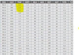
Here is the Lynchburg profile at 6 am-- I highlighted the last three layers, or about 1500 feet of the atmosphere that's above freezing. However, it's only a few degrees, like 36-37 so if it comes down hard we COULD hoover around around 33 with some snow. My hunch is the rain stays BARELY east of us and once it cools we are basically dry.

Near miss with moisture and temps... don't be shocked to see a few flurries.
Batten Down the Hatches.
SuperStorm Monday...
Sandy has done pretty much as expected-- she swung out east to near 70 longitude and is not making the shift west. My thoughts were Atlantic City to near Philly to near Hagerstown, MD.
That's going to be rather close-and she's gotten stronger with pressure down to 942 MB.
We've had light to moderate rain region wide over night and the snow change has been sooner than anticipated with snowfall into Blackburg and Hot Springs already.
Rain region wide today with temps steady or even falling slowly. Winds should be increasing as the day goes on.
I'll update with some model data at noon. With the snow change earlier, will have the evaluate. If you look at this radar look..
http://radar.weather.gov/radar.php?rid=FCX&product=NCR&overlay=11101111&loop=yes
snow in the mountains and MAYBE already west of Martinsville.
Subscribe to:
Posts (Atom)