Tuesday, August 28, 2012

Expecting Isaac to be upgraded to a cane--

Isaac has been the SLOWEST developing storm I've even watched- like paint drying. Giving the NHC full credit, they said it would be a slow process and they were correct. Next update should have it at 75 MPH, maybe 80. It may get close to 100 MPH, but not much more. The official forecast is for it to remain a Cat 1 storm.

Note this image where the convection is finally wrapped around the eye. As this builds, the storm should get stronger.


The bigger problem will end up being rain and flooding. 90-100 MPH winds are dangerous, but they will be confined to the most outlying and coastal areas. There will be widespread power outages, but it should not be total devastation.

NHC preferred track.


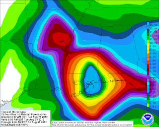
Rainfall will be the biggest issue. Strongest winds and rains are always to the center (eye) and east of the system. Note the rain is forecast to be heaviest to the east of the landfall spot. New Orleans gets off with only 8-12 inches of rain while Southern Mississippi gets 15-18 inches.


Monday, August 27, 2012

Isaac very close to hurricane status..

If we are splitting hairs and making an argument for people to remain vigilant in the path of a storm, I'd have upgraded Issac to Hurricane Status at the 4PM advisory. The ability of modern science to see a storm from SO many angles-- satellite, radar, microwave, Hurricane Hunters and the advancement of computer modeling has made data overwhelming. With that, I trust their judgement and in it's proper time it will be Hurricane Issac.

Isaac has been SLOW in developing because of various patches of dry air along its path. There has also been a couple synoptic features along the path that has slowed the process. Ironically, if we are looking at things from a risk perspective, it would be better to have a storm peak over the mid gulf and be on the down side of it's top strength than peak or gaining strength at landfall. 

I've attached a recent enhanced sat pic of Issac-- there is plenty of colder cloud tops to the S and W of the center/eye. If those colder cold tops wrap around the center, we could get a period of rapid intensification. 


Isaac the enigma!

My apologies to those who read and expect updates from me. My Father's house has an older computer and between the computer freezing up every 10 minutes or so keeping track of my three kids, updates were not just in the card. The lack of cell service at his house sealed the deal.

Isaac the enigma has done everything in it's power to avoid land, not strengthen and be a difficult storm to track via both landfall location and intensity. It missed MOST of Hispaniola and clipped Cuba where it barely was over land BUT never really gained much intensity. Now it's in the Gulf  and as of this current update STILL has not reached Hurricane status. 

Where is it going?

Well, LAND! My thoughts last week near Pensacola were not bad but it looks to be a tad west of that, likely near New Orleans. And, the angle it is taking looks to be a "worst case" for the city built under sea level. I'm not sold on the current NHC track or timing because it has struggled to be stronger. YES, it could blow up soon-- but there are some synoptic features that could inhibit this. In a worst case, it COULD blow up to a Cat 3, in a best case it's a disorganized mess and is barely a Cat 1. It's going to CRAWL for the Wednesday to Friday time period- moving maybe 100 miles those total days. Flooding will be a HUGE issue to the near and to the EAST of the center. 

More updates later today. 

Check out http://icyclone.com/  or find him on FB under the same name for updates from his chase. 


Friday, August 24, 2012

Friday Afternoon

Model data still indicates that Isaac scrapes part of Cuba-- passes the FL Keys and goes into the Gulf of Mexico. Could end up at Major Hurricane in a worse case that currently seems to be 100 miles either side of Pensacola. FL

On the road and will be at my Dad's over the weekend. More limited access to computer data, but will update when I can.

Isaac-- South and weak

Isaac has been an interesting storm so far. While the conversation swirled around where he would cross Hispaniola and the track from there, the bigger concern SHOULD have been it's overall lack of strength. It has been unable to to pull together one main center and as a result has not gain much strength.

We briefly had Joyce, but she's back to a depression.

Isaac- I still favor the southern track. It should start to get somewhat stronger, hit Cuba as a stronger tropical storm and once it emerges into the Gulf of Mexico, it's a hot tub there and it could have a day or two of RAPID strengthening. That's my preferred track at this time but we've not ruled out any other options at this time. I wish I had stated my "target" at that point was Pensacola, FL because it's been fun watching the models trend where I thought they would. With that, models are just guidance and we can expect wild swings in this thing still.

Summary- Isaac scrapes far western Haiti, goes across much of Cuba as a rainy but weak tropical storm and emerges in the Gulf of Mexico early Monday. If it follows the NHC and my preferred track, we could see a Cat 3 in the GOM at some point late Monday/early Tuesday. Anyone on the western side of FL all they way over the LA/TX border should keep keep their eyes and ears open.


Wednesday, August 22, 2012

Quick Isaac Update

Track has been a little north of what I thought-- and on some levels seems destined to bump into every piece of land possible-- hits Hispaniola, scrapes Cuba, near the southern tip of FL and along the W coast of FL. With all the land obstacles in the near future, the best chance we have of seeing this thing become a STRONGER hurricane is if it can migrate west into GOM away from land. 

Latest NHC Map--

Will update later with latest guidance and more detailed speculation. 

Tuesday, August 21, 2012

Isaac on the docket...

Isaac formed and is now not far from impacting the Leeward Islands by this time tomorrow. It should hit Hurricane status just past this point.


From here, the speculation is does it stay far enough south and NOT get beat up badly by Hispaniola. There are mountain peaks OVER 10k ft on that island and it would not be the first time a 'Cane never reached it's potential due to land interaction. Guidance has shown some variety-and the NHC has marked this as the most likely track.

It will eventually take a NW jog-- and it depends how quickly.

My guess so far is it takes the south side of the "cone" over the next 24 hours and we will adjust from there. US interest from FL SW into the Gulf should monitor at this point.

Here's a quick loop from the GFDL-- crosses the storm over Hispaniola, emerges into the Bahamas and hits in the vicinity of Miami.
http://raleighwx.americanwx.com/models/gfdl/18zgfdl500mbHGHTPMSLgfdlLoop.html